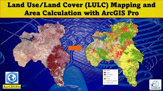
Sentinel-2 Landuse Landcover Classification Using ArcGIS pro

HTML-код
- Опубликовано: 9 сен 2024
- Sentinel-2 is an Earth observation mission from the Copernicus Programme that systematically acquires optical imagery at high spatial resolution (10 m to 60 m) over land and coastal waters. and it supports a broad range of services and applications such as agricultural monitoring, emergencies management, land cover classification etc
This video details on how to carry out Land use Land cover classification using the Sentinel 2.


whats the interpolation for?
Hi, where did you download the Sentinel-2 data? Please assist me with the source.
ruclips.net/video/BM-Ki8SAsAw/видео.html