Navigation - Tides Problem Explained

HTML-код
- Опубликовано: 2 окт 2024
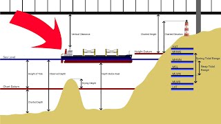
- Capt. Dave Medeiros explains how to determine the depth of water at your destination using the tide information given.
Looking to become a licensed mariner or continue your professional maritime training? Obtain your training and certification with Northeast Maritime Institute. We offer on-site and online training for US and International seafarers. Visit www.northeastmaritime.com for more information.
Explore and subscribe to our RUclips page for more maritime content!
Navigation Plotting is an essential skill for working in the maritime industry. This video is an introduction to some of those concepts. If you've spent lots of time on the water, but have not pursued a professional license, you should consider yourself a candidate for an Operator of Uninspected Passenger Vessels (OUPV) 6-Pack license. This license allows you to charter vessels with up to 6 paying passenger and is the first step to a career in the maritime industry, full-time or part-time!
Copyright © Northeast Maritime Institute


This really helped out with my University work thanks.
I go to a maritime academy right now and i just wanted to say that Captain Medeiros is an absolutely excellent instructor much better than anybody ive ever had before. Captain Medeiros explains everything so clearly and I have watched all of these videos. Thank You
NLB 1
This video is great. I'll go on board this September as a cadet and it teaches me well.
However, 5:37 is closest to 5:40 .. at 16:00 in this video. But the answer will be the same. Thanks to the people who made this,specially to the instructor. More Power!
I really thank the people behind for uploading this video and to the instructor as well you've done a good job sir thank a lot
Thank you!
When we know the range 2,7 ft, we use the 1/12 rule. First hour 1/12 (in this example), second hour 2/12, thrird 3/12, fourth 3/12, Fifth 2/12 and sixt 1/12. So at 09:14 we ad 2,7 x 1/12 (=0,22) to the 14,4 ft, makes 14,6 water depth at 09:14
Another well explained Video Capt!. On table 3, Although our duration was solved for 05:37 and there was a 05:40 option you chose the 06:00 option. I was curious, however it was good to see that choosing either the 06:00 or 05:40 didnt make much difference. Thanks!
Thank you for this, I needed a good refresher
Thank you alot
Mr. Ohm is Simon of Ohm's law.
amazing!
HI dAVE DO YOU HAVE BEGINNERS CHARTWORK VIDEOS AVAILABLE FROM DAY SKIPPER TO OCEAN YACHMASTER ???
is it possible to interpolate to find the correction factor by duration/range: x/time to nearest tide ? then just add/subtract it to the nearest tide
Yes
thank you so much for posting videos like this one it helps out a lot please post more
Im updated as deckwatchkeeping thnx
Thank you for all that you have given to help mariners understand and learn.
Why my gadget cant download navigation training on u tube? 😭😭😭
Want to learn more about tides !! Check this out ruclips.net/video/firWqNWmSsU/видео.html
OHG page 817
The closes time of tide duration to 5h37min is 5h 40 min, .....NOT 6h 0min...
Well that’ll definitely kill some time when I’m floating around on a windless day.
A somewhat difficult area of knowledge to explain and teach effectively. Thanks for making the effort here ! P.S. There is literally no such word in the English language as "asterick". The proper term is ASTERISK.
Very helpful, thank you
so polite.
thank you sir, its really helpful even without knowing exactly what tides are , I understand what needed to know and how to do calculation.
This is really helpful except the measurements are in feet hahahahaa but its ok though still got the info!!!
Hi Sir Can I ask you about what is the importance of accurately calculating and measuring the navigational information?
this video is 7 years old bro
@@danjarvis6980 Good morning Sir, Can I ask you? how can you explain the Knowledge in calculating the Errors in the WGS'84 Dtum prior to plotting the positions in the chart? I hope you will answer my question immediately, Thank you💛.
Where do Tidal reference usually available? I want to teach my students in oceanography about this but i have no idea where to find a reference table on tidal. Im from Philippines.
Sir can I ask you a question? What if the height of tide in feet is negative, Should I add or subratct it to the charted depth? Im a marine student Sir i hope you can help me.
17ft is Charted depth and -1.2ft is the height of tide in feet, should I add them Sir?
I can't imagine being able to know the amount of information you'd need to know to pass a USCG exam.
That is why you take a class with an approved school. We are one!
tnx a lot sir
A bit puzzled. June 18, 2020. All very clear to me except I saw some negative depths given. In the UK and presumably everywhere else that means a drying height exposing hard nasty stuff to the minus figure. Which then threw me for the rest of your presentation. Help!
negative 'depths' on a chart are indeed drying heights
heights given in tide tables are relative to CD (Chart Datum)
CD is normally approximately LAT (Lowest Astronomical Tide) BUT tides can be weird - so a tide height of -0.1 would be 0.1 units BELOW CD but not necessarily drying e.g. if a harbour entrance has a chart-marked depth of 2m and there is an extreme spring tide low with a height of -0.1m then the depth of water at the entrance would be 1.9m (ignoring other factors that may affect height)
Yeah, the negative just means lower than the Lower Low Mean Average from the last 19 years of Lower Low Tides. The Springs tides we get twice a month on the East Coast in US quite often “go negative”. It just means the water is lower than usual at low tide by that much for all the Charted Depths of that area. IE, at low tide with a -1ft for that day means Every charted depth number you see on that chart you will actually have 1ft less than that at Low Tide.
Negative Numbers you subtract from Charted Depths on you Map. Positive numbers you Add to the Charted Depths on the Map.
So if you are fishing at exactly where the Chart says 10ft of water, then that means that is the Average Low Tide depth at that location. So that mean the Water is only 10ft at low tide and the rest of the day deeper than that. At anytime of day you look at the Tide Tables then you Add any positive numbers given for the tide or subtract if negative to find the Actual depth for a Given Time of a Given Day.
Anchorage