Dead Reckoning - the basics

HTML-код
- Опубликовано: 22 мар 2012
- This video is designed to complement the content of this page - www.pzsc.org.uk/shorebased
Here at Penzance Sailing Club our active Training Group comprises of volunteers with a variety of experiences and qualifications.
The main aims of our Training Group is to encourage people in West Cornwall to take up sailing, enjoy the experience and be safe on the water.
Find out more at www.pzsc.org.uk/shorebased
The content of these videos is put together in good faith and is constantly evolving. It is possible that errors exist within this content.
If you spot an error or would like to add anything to these pages please email webmaster@pzsc.org.uk
Watching this content is not a substitute for completing a RYA Shorebased course or similar.  Спорт
Спорт


Tell your kids " put down those cell phones and pickup a ruler and compass." Love these videos. Thank you
you guys do a great job - thank you
Fantastic work. I am sharing this with friends. I would love to make such videos but have speech difficulties as well. Keep up the good work. Very clear, succinct and well presented. Excellent job! Thank you. Warm regards.
@Linda Grace Thank you very much Linda. Warm regards, DP
very helpful thanks
great video!!!
Bob Yuan - thanks. Our website that goes with these videos may also be of interest pzsc.org.uk/shorebased
I see land and sea on a screen. I am looking to know how you plot a couse. Like the Pannama canal to Australia, stopping at some of the islands. Can you point to a place (S) so as you go. You know where you are going. Maybe time to get there. Thanks
So can anyone tell me the amount of stress one goes thru while doing this mid flight. I havent flown yet but I can Imagine this is extremely difficult
Hi John - Sorry on just seen your comment. Sometimes you add and other times you subtract variation. More details can be found on this website - www.sailtrain.co.uk/navigation/variation.htm
I’m surprised at all the decision of conversion to true north. I understand the ultimate accuracy argument but we always just use magnetic for everything. Way simpler. Compass reads true, true is on chart and the variation changes so little it does not matter. We only had parallel rulers so after we had made our best guess at the course sailed ( to nearest 5 deg) we would walk that course from the compass rose magnetic ring to the last position we had plotted with DR or confirmed another way. If we felt like getting really fancy we would add the compass deviation but it was never more than 1-1/2 degs so not of much consequence.
Much more important was to add the off set for the tidal current to the course.
Thanks for posting about DR , still an important simple way to navigate.
Cheers Warren
Thank you for the comment. In the UK there is currently not a lot of difference between true and magnetic. However, in other parts of the world it is far more important to make the adjustment. The map on this page give you an idea of how important it could be en.m.wikipedia.org/wiki/Magnetic_declination
The term comes from deduced reckoning hence ded reckoning, not dead reckoning. Also, if I remember correctly from my flying ground courses on navigation, we were taught how to add or substract from magnetic to true heading with the following sentence: East is least, west is best. So a west correction would require an addition, not a substraction. Hey, but I might be wrong on both. Look it up.
I have seen both ded and dead reckoning used for calculations both on water (as here) and in the air. Dead reckoning is the term commonly used on the water.
My understanding is the dead reckoning in the air takes in more variables than dead reckoning on the water (I have no experience of this).
The phase I think you are recalling is:
“Variation West, Compass Best - Variation East, Compass Least”
In this case variation is west so compass best (or the larger number of compass and true), therefore to get from compass to true we subtract.
See more here
www.pzsc.org.uk/shorebased/content/mag_north.html
Where can I buy you now use Parallel Rulers.
thank you!
Would you not also compensate for tide and leeway? 6.5Nm is presumably measured via the log, which is distance through the water, but not over the ground.
Malcolm Howe - DR is the most basic of calculation of our position, allowing for direction and distance only. See our video of Estimated Position which starts with a DR and then allows for tide.
My question how do you know how far you've traveled in a set time?
Hi. You need to have some way of measuring how far you have travelled through the water for this method to work. This normally means using a device commonly know as a "log" - normally a small paddlewheel that turns as water passes by it. The number of rotations are recorded (normally electronically) and then displayed as a distance.
The same device will normally display the vessels speed at any given time.
Love that accent..
sir good sir i wish i found you a few days ago so maybe i could just asked you if you could show us how to do runnig fix i have my last exam tomorrow i hope i will pass... but if you could post runnig fix one day that would be awesome thank you already
Sorry we are not able to do this at the moment - however have a look at this site www.sailtrain.co.uk/navigation/running.htm
What if you drift off course and you find that you haven't been following the set heading?
Firstly it is never going to the exact but if we can stay close to course it is always going to give a more accurate position.
If you do go off course it is best to the helm to be honest and make the best judgement of the actual bearing followed. It is then even more important that you allow for a larger margin of error.
Not bad! it's true but only if this variation is for the year of sailing. And you didn't mention the deviation
Thank you for the comment. This video is designed to be a simple introduction to the topic hence deviation is not included.
For more details it should be used with the website detailed in the text - www.pzsc.org.uk/shorebased/content/chartwork_dr.html
On this page there are more details and a link explaining True and Magnetic north and the changes in variation over time.
Why do you subtract variation besides adding?
7W = (-7); 7E = (+7)
+Павел Киров Yes, it's true but only if this variation is for the year of sailing
could this method work in aviation's dead reckoning?
Yes, but you need to add wind correction too.
Same stuff mate but with wind
Why do you convert to ºT instead of doing the whole problem in magnetic?
Hi
We convert to "True" because charts are drawn to true north is. stringer up the chart. So if we want to plot a bearing line on a chart it must be in true.
You might then ask why do we not draw a chart on magnetic north however magnetic north moves around over time where as true north is fixed.
Hope that helps.
+Penzance Sailing Club But why not just set the bearing from the compass at the 7ºW mark on the protractor? That would eliminate the step of subtracting for variation.
+GaskellleoCinema I think you are describing Method 1 here: www.pzsc.org.uk/shorebased/content/mag_north.html
In which case (if I understand you correctly) you are still doing the subtraction just in a different way.
impressive! but why is this method obsolete now?
Toby Que. Not so much obsolete, simply we tend to have access to a GPS which, we hope, will get us a much better idea of our position. If the GPS goes wrong, runs out of power or is dropped overboard this is the back up.
Penzance Sailing Club
I see...
Why not just plot magnetic and use the variation compass on the chart?
When we are plotting a DR position we are looking at the past, normally the past hour or two.
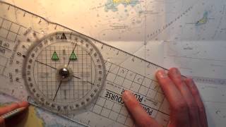
All bearings on a chart are measured from true north (straight up to the top of the chart) so it is important that you first convert your course over the ground to “true” from “magnetic” if taken from a magnetic compass.
See www.pzsc.org.uk/shorebased/content/mag_north.html for more details.
@@pzsc does the chart not also have a magnetic compas rose?
@@matthewkorwel1099 The chart will have a compass rose aligned with true north. On this there is an arrow that shows you magnetic north at a fixed moment in time (normal around the time the chart is published) however the position of magnetic north changes all the time.
In terms of measuring bearings all over the chart it is easier to measure these using the north lines that run across the chart and are aligned with true north and then make the adjustment.
Wrong! When variation is West he supposed to add to get True course. He subtracted so now he is 14 deg. off!
"West is best" you add, "East is least" you subtract.
Hi Billy, thank for the comment.
The full saying is "Variation West, Compass Best - Variation East, Compass Least".
In this case, the variation is west, therefore we use the first part - Variation West, Compass Best.
This means that the Magnetic (Compass) bearing will be larger than the True bearing.
In this example, we have started with a Magnetic bearing of 146 degrees and subtracted 7 degrees so that the True bearing was the smaller number.
This gives an answer of 139 degrees true.
See pzsc.org.uk/shorebased/true-and-magnetic-ds-ym/
Ok, I see what you are saying. I am used to starting with the True
heading when planning the passage. You're calculating from Magnetic, so
you have to compensate in opposite direction. That makes sense now. And I was wrong.
Fair winds!
Cheers.
actually if the heading was north (M) and a variation of 7 west , then the true course is west of north , 360 - 7 = 353 (T), so subtract if compass bearing has west deviation to get true reading and vice versa
True Virgins Make Dull Companions!
True Heading + variation ( West is best east is least)= Magnetic Heading + Deviation = Compass Heading
That's what we learn flying airplanes! or.. Captains don't meet virgins twice.. backwards works too!
West is best, so you should add 7degrees
Hi - thank for the comment. The full phase you are using here is "Variation West, Compass Best - Variation East, Compass Least" for this example you need to use the first part of this as the variation is 7 West "Variation West, Compass Best". This translates to "because the variation is west the compass (or magnetic) course will be the biggest number. Therefore, we know that the magnetic course will be 7 degrees greater than the true course. We, therefore, subtract 7 from the magnetic course. This is not the only way to remember this rule see our notes here - pzsc.org.uk/shorebased/north/
@@pzsc Sorry, I see now, you start with magnetic. Yes, from true to mag, substract it is!
HAHAHAH
World is flat?
No, but we can approximate the surface of the earth as being flat over small distances.
@@pzsc thanks for the reply, what distances we talking about, couple of miles squared, few hundred miles?
Across the English Channel would be fine (50-100 nm), if you are going further then look into Ocean Yachtmaster.
@@pzsc 8 inches of curvature per square mile, that's almost 784 meters difference... just under a km?? just trying to debunk something here...
Good tutorial but I think it would be nicer if you minimize your tongue clicking. :)