His videos are so many times better and more accurate as so many other of the videos on RUclips. So found a video from a person who started his video with the words “...... those videos contains so many errors ...........”. In his own video I detected his first big error after 2 minutes, the second after 3,5 minutes, and so it was going on the whole video long. In about 20 minutes I captured more than 10 errors. And he is not the only one. Sometimes I still have a little problem with his waffling, I am a Dutch speaking Belgian and sometimes it is hard for me to understand him. But after replayed several times it becomes clear to me. I agree he can go on with his waffling, his talking’s are always interesting. I enjoy it, and sometimes I learned some extra’s. A win - win situation.
I quite enjoy the inclusion of the medieval history references. In fact, combining map reading and these locations, especially considering most travel shows dealing with medieval history, never get more than a few meters away from roadways really adds to your commentary.
Do NOT stop "waffling" as you so charmingly call it. I absolutely enjoy every "waffle". Nothing so enhances a trip or journey as looking for what came long before! An "Over-The-Road" Trucker in the States. Greetings and best wishes from Tennessee, USA.
You absolutely don't have to orient your map but it doesn't hurt to do it. I always do it becaue it makes life a little easier🙂 I find it's easier to teach map skills to newbies when you orient your map as they can visualize whats happening along with the explainations they are given.
when dealing with a compass i always teach them not to, as then reading the symbols and text is easiest so they make less mistakes on taking reference points for they position.. (rotatign back and forth between identifying a reference point you can see then rotating to read what it actually is on the map.) my quick rule is when walking on a mapuse the map (ie orient it to your direction of travel) when traveling/using a bearing/compass you use the compass as your orientation. it also prevents north south mistakes where they turn teh map 180 degrees and go teh opposite of where they shoul be going because they did not rotate their compas correctly but rotated the map instead.
My old Scout Master always said you'll get the same bearing using a map & compass whether in sun or fog, meaning that you don't have to be aware of your surroundings (trust your map, but no need to orient it).
@@Megacheez I don't quite understand how someone who wants to teach people how to navigate using a map that is made up with symbols, that are specific and need to be consistent in order to be useful, refuses to use language symbols properly when communicating in the written word.
I understood what you meant from the start. I was taught map reading by the Army, and use whatever method ‘works’ best. Taking a bearing from the map is not affected by the direction the map points in. How you hold a map when you’re walking, hiking or running, in inclement weather, is important. If you want to minimise your time scrutinising your map, it’s worth developing a method whereby a quick glance at your map keeps you on track? That might mean orientating your map, holding it in position, your thumb on your destination or target enabling you to make quicker navigational decisions. It isn’t rocket science, but as you point out map reading in itself is enjoyable, gaining the skill is great fun, it’ll spur you on to other adventures as your confidence increases. Your explanations are clear and concise, much better than mine could be. I like that you count contours, a profile tool so often missed by so many people. Thanks for a great vid.
Please continue the waffle! In addition to the instructional value of the video, your backdrop, stories, and waffle provide insight into the history and culture of England we can't find elsewhere!
Hello from Ohio in the USA. Fairly new to the channel and very much enjoying it. You are a good teacher and I appreciate the time and effort you put into your content! If you were to ask me, I’d encourage you to keep waffling and sharing the history and your insights. I enjoy learning, not only land navigation, but history. I had no idea what the cross was that was your destination. And then you pointed to the remains, a pole standing by a wall in the middle of nowhere…Then your history lesson made it all clear and I thank you for that
Hi.. the 'pole' is in fact a solid piece of carved stone. As mentioned, the broken top and cross section probably ended in the repair of a boundary wall. Old gate posts were frequently made of stone too.
I don’t care what anyone says, I love the history tidbits and would miss them if they weren’t included. It appears that so many others enjoy them as well! I say we all give a very strong thumbs up in hopes that you start a second channel that is exclusively about history (and a few science tidbits too!)
I was trained old school, stumbling out in the woods, with stones and sticks in my pocket to count my steps on a bearing I checked over and over as the terrain changed only to end up exactly on the road or landmark I was aiming for at exactly my pace count. This stuff works!
Yes, it works. I've hiked in zero visibility in Alaska carefully following a bearing and distance and after about an hour, was within about 200 feet of intended destination. A good compass is useful and keeping it away from possible magnetic things on your body or backpack is probably essential. i was with a man who was using a lensatic compass and he always wanted to go left; round and round in a circle. Eventually realized his eyeglasses were attracting the needle.
I'd describe those bits as tangents, and yours are wonderfully interesting and entertaining. I typically "orien" my maps towards the best source for beer. Cheers!
Boy am I glad to see your video on this topic! Ever since I started watching navigational videos It bugged me whenever someone would start out by saying that you need to orient your map when you first start doing anything. You explained this perfectly! I absolutely love watching your videos so keep on waffling.
I love the waffling. It adds so many dimensions to the video. I'm not in Great Britain and so dont have these types of markers. It's fascinating to learn from these little side trips.
I personally think this channel needs to go viral or this video at least - anybody with 1 million followers😅?! This is the absolute best channel on this topic especially with the added history lesson and very charming waffle😂 we have all learnt so much from this master! He deserves credit and recognition. I've shared it to my contacts... let's all share it!❤🎉🎉
I love when you waffle. I have been trying to get this concept down for years and you are the only one that explained it in a way I finally understand and that is not needing to orient the map when you are using a compass!! Thank you for helping me understand this concept.
Very enjoyable video and nothing that needs cutting out. Great live filming much better than just a sanitised version of it. Comes across as having a wide knowledge and thoughtfulness.
Waffling is great! I learn as much from the excursions as the main point!😊. It is useful information, because it orients us modern humans in history. Modern people tend to forget that we are a product of our past and the reasons for what we have, say and do now often have roots in the past. Thanks for reminding us that we have a lot to be thankful for, and we don’t need to live as though life’s problems haven’t been encountered and addressed before.
If you don’t know where you are, orienting your map will help figure out where you are. Depending on the terrain, of course. I enjoyed your history lesson.
Thanks for such a clear explanation! It brought back memories of what I learned from a neighbour (retired marine survival instructor) growing up on Dartmoor over 50 years ago. He always emphasised the importance of compensating for magnetic declination, which back then was around 9 degrees - a crucial detail, especially with Dartmoor’s infamous 'mists' that could roll in without warning and blanket the moor in an impenetrable cloak. The largely featureless landscape only added to the challenge, often leading to tourists getting hopelessly lost. Fortunately the chance of getting lost today is far less likely with the advent of GPS devices and advanced mobile phones (provided the battery and signal hold up). But IMHO the ability to read a map properly is just as important, and also adds to the fun - as it can help you better engage with your surroundings, and identify easier routes and discover interesting locations. P.S. Much MORE waffle please - as it makes your videos all the more interesting...👍
I agree with the previous commenters: I love it when you waffle. I learn a lot during those tangents. I also love how you say, "Just fast-forward through that bit" AT THE END of the bit. 🤣. Love your videos. Cheers from Colorado, USA.
I was taught to orient maps to north in Scouts, as a way of helping figure out where I was. Find north with the compass, turn around until you're facing north with the map pointing north, and work from there. I think rotating on the spot was a way of making sure the expensive maps didn't get dropped into mud. I even do it with road maps now, when trying to solve the issue of where I've ended up while trying to find somewhere else, in an area that looks exactly the same as where I was 50 miles ago. Useful when google isn't cooperating. There's nothing wrong with the waffling. Education is always good!
Your "waffle" is always worthwhile. Historical context creates deeper understanding, but even if there was no obvious practical benefit, the departures are interesting and entertaining. I love how you end up leaving everything in despite resolving at the time to cut it out. 😄
Ride a cock-horse to Banbury Cross, To see a fine lady upon a white horse; Rings on her fingers and bells on her toes, And she shall have music wherever she goes
Imagine if the navigator on an aircraft carrier had to swing the ship around to the north every time he wanted to take a bearing from his chart. Love the channel, you've inspired me to dig out my old topo sheets and compass. Good luck!
It's exactly the same when it comes to the necessity of orienting a map (or chart) in order to plot a bearing. I'm a pilot, for what it's worth, and we don't find it necessary to orient our charts in order to plot bearings either.@@krasht1
Its not necessary to turn the ship. Geez if you don’t understand you should not comment. You have a compass affixed in the ship. It will tell you where magnetic north is. Since you know the ships heading based on the compass you simply orient the chart to the ship. And to find where you ARE on the chart exactly or very close needs a sextant or a GPS or an accurate reference from the last known location. However, not getting the map orientated to the direction of travel might mean running aground on some island you did not know was there because the chart was upside down. Or flying your aircraft into a mountain or falling off a cliff in the dark. In the military, in aircraft and on a water craft out of sight of land you better know what is around you and where it is. If you are walking around in an open area with unlimited visibility then its not so important. AND if you do not know where you are on the map in order to find your location from TERRAIN features or even a distant church steeple you gotta orient the map. So you better know how.
I’ve always loved reading maps and all the icons and information. Now I will learn even better how to use them with a compass. I’ve been teaching my daughter too. I look forward to going through all your videos. Love your history waffles don’t delete them!
Just found your channel. Liked the bit of history personally. Coming from USA we dont have the luxury of such well preserved ancient landmarks! I bought a lot of land nav /backpacking stuff a while ago but never printed maps as i couldn't figure out exactly what i wanted printed. Thanks for the reminder to finish what i started.
You do a great job of covering all of the practical elements of wilderness travel. And your neighborhood there is spectacular; visiting may be a new bucket list item. Thanks for sharing your knowledge.
Great presentation! Please don't take out the historical bits! They are priceless bits of knowledge. We are all richer for them, and those who don't want to watch them are free to fast-forward. That's a lovely bit of country there. Much greener than where I live in Las Vegas. The desert has it's own kind of beauty, but one has to learn how to look at it. Cheers!
Great video! As an former military engineer I enjoyed the video, even the wafflely bits, the incite to our history escaped me when I was younger and I appreciate more now! Keep being you and embrace the opportunity to share your knowledge. PS: As a formerlly Military Engineer I still orientate plans etc to the ground onsite before discussing anything about them with colleagues, it really helps people being aware of what's going on!
Thank You Sir !!!! I watch all your videos at least twice. Please know, that you give the most informative videos on map and compass navigation, on RUclips. I think that anyone following you has learned from your examples. Keep up the good work the Waffles, and stay safe.
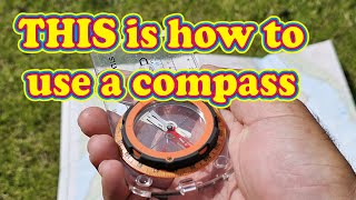
The video was delightfully, entertaining. To answer the original question in a simple form: When you align the orienting lines of a base plate compass with the grid lines on a map then you are orienting your map and compass. Likewise when you align the illuminated index mark on a Cammenga compass with the grid lines. 👍😎
Great content as always Wayne, thankyou. Where I think orientation is useful (in the modern world) is using maps on phones, especially at the start of a journey - often times one doesn't know where North (or any cardinal point) is, so orientating oneself to the local area/landscape and knowing the direction of travel will invariably prevent errors. Keep up the great work and hopefully see you on a course (or socially) again. Cheers! FYI, Wayne runs excellent navigation courses.
I enjoyed this. The bit of history about those crosses was a nice bonus. I occasionally encounter old items on my hikes, but "old" where I live is measured in mere decades against the hundreds of years worth of history you were standing next to in your video.
Great informative video, please keep them coming I’m certainly learning some good stuff from you and don’t stop the waffle it’s entertaining and sometimes funny
Useful video and one I’ve never thought about. My math and logic brain understands exactly what you are teaching us here and the message is understood…but we both know I am going to keep orienting my map. It feels odd just talking about not doing it. 😂
I decided that I was going to find your map's area using Google Maps and I found it using the Clattering River as a reference point and using the satellite view, I was able to see all the points on your map in the video. I love this!
I attended an orienteering course where this was the most difficult concept for some students to grasp. We were in a classroom setting plotting a route and yet they were fixated on the needle. They couldn't understand that they just needed to measure the angles.
I've never done any rambling or orienteering, but I learned to navigate as part of the requirements to get my private pilots licence. In the confined space of a light aircraft it would be rather inconvenient rotating maps around, especially since they're generally held down to your thigh. Furthermore having the map oriented to line up with the physical geography would be missleading, as heading in the direction indicated on the map would have you missing your target (due to the effects of wind speed and direction). When I got a boat the same principles apply. Allowance needs to be made based on heading and speed of the vessel combined with the speed and heading of the prevailing water current. I believe that this is why it's only the Army that "orients" its maps. It can be useful when you're travelling across terra firma, but navigating through a fluid medium means your heading is not necessarily the same as your direction of travel.
Orienteering, measuring the angles? Make your route choice, ID the correct direction to run in and "tick" off features as you pass them. Only number to worry about is the control code. (Dont misspunch)
Its certainly not waffle or irrelevant , love the education and explanation you give - please keep sharing and teaching - my 6 year old Grandson and I are fans and are learning so much beyond his path finding skills that I set out to teach him
arrhhhh, now i understand you, it was just semantics from my part. I always oriented my map back in the day when I knew how to use it properly, having a map not oriented just didn't make sense to me.
The Norwegian army orient the map not because of "dogma" but because it is easier to find the lay of the land that way. When you are tired, cold and hungry it makes no sense not to orient the map, it just complicates visual navigation.
In school we had an exercise where we walked along a marked path. At various stages we were asked to point out where on the map we were. Great exercise in reading a map and keeping track of where you are. As for using a compass, some people never understood what you say in this video. They would move around to orient their map instead of e.g. using a handy tree stump to get a good surface for taking a compass bearing.
The reason the army does how it does, is because of lowest common denominator. Its easier to visualize for any recruit, if you point everything to the north. So a compass will help you find north, but if you lost it, you only need another way to estimate north, but the rest of procedure is basically the same. What I'm trying to say is, having a similar standard for orienting in under all circomstances, is easier to remeber when under pressure.
Most military use lensatic compass, which can’t be easily used to determine an accurate azimuth to follow. One uses a protractor, then inputs that number on their compass and off you go. The Silva you had eliminates that extra steps. I learned to read maps without turning them 95% of the time (only turning on especially complicated areas). I also often used a compass calibrated in Mils (6400 Mils in a circle). The Artillery uses that simpler measurement instead of degrees, minutes, and seconds. (Much like the metric vs imperial).
People learn more if they’re in a good humour and you achieve that. It’s not waffle but informal information. Tiny point, the dissolution of the monasteries took place in the 16th Century, around the 1530s. Useful video, as always. Many thanks.
I love the historical aspect, and context! thank you so much for sharing.i've always lived in southern New England USA my whole life. I live on the coast and grew up going on boats with my Dad. We were most of the time close to land and could get by with dead reckoning, except in the fog. For example going from Block Island to Watch Hill Rhode Island. Before GPS we used maps , compass and bearings and a fog horn (before radar)! Lately I've gotten into camping up north and woods get pretty big and its easy to get lost /loose a trail, so thank you for sharing ! (ps- we lived in Canterbury, GB 1973-75 as my Dad had a job there at the time ) Cheers!
Well I am glad you didn't delete what you did show. I have been on this bit o rock near 6 decades and I learned several things new because you did not delete the part you showed us.
Came for the map talk, subscribed for the waffling. I think those bits of related information bring much more meaning to the larger subject being discussed, and the brief asides about the significance of these local and often overlooked landmarks are inspiring--I now want to find maps of some of my favorite country and plan hikes to specific features to learn more about them.
We used to draw magnetic declination lines directly on the map with about the same spacing as the grid lines. Rotate the bezel to align with the drawn in declination lines and you’ve got your azimuth already corrected for declination.
I wouldn’t even call it waffle. It’s all interesting stuff. I certainly wouldn’t consider asking you to delete anything. Thanks for making these videos 👍
Your channel is great because you are great and because you understand what you are doing. The biggest issue is that sometimes we learn something without having a clear understanding of why.
'I strongly suggest you don't watch that bit...that you had to watch in order to hear me 'say don't watch that bit'. Thanks for the retrospective heads up! Great video; thanks! More waffle please, it's excellent.
Fantastic video. It would be great if you made some hiking videos, taking us to some places of interest like Nappa Cross, explaining the history or points of interest, but more importantly, showing the navigation skills in progress as you go along. Your tutorial videos are great, but seeing the navigation process in use 'live' along the journey is a great way to repeat the lessons in the context of an actual hike, if you get what I mean - just an idea 😊 You have inspired me to get out with map and compass, and to enjoy the satisfaction of successfully navigating a hike without having to fall back on gps.
Second one I've watched of yours and I really enjoy them. I haven't used a map and compass in years! In fact, rarely did I use the compass. Would never regard myself as proficient simply because of the irregularity of use, but I did regard it as common sense that I didn't need to orientate the map to take a compass bearing. Just as an added note, I love all the extra snippets of information, aka, waffle.
In short: „Ignore the little spinny magnet inside when you don't need it, and use just the rotating protractor around it to measure (relative) angles”.
I enjoyed the waffle! I'll add some waffle of my own: The word for both "south" and "right" in Welsh is identical ("de"). So, if a map was oriented according to the true meaning of the word, with east at the top, the south would be to the right. I think some other European languages also share the same word for both "right" and "south" but I can't remember which ones.
When we were doing week long mountain treks we would do as you do, glancing at the map as we go orienting based off our direction of travel. If there is ever a slight hint of uncertainty or question, that's when we'd take the extra time to shoot a few bearings and orient before we made a mistake. Great video, need to get back out onto the trails soon.
Loved the video and the history lesson! I've only ever used a map protractor for taking grid bearings. I use my compass almost exclusively for shooting azimuths


Don't worry any worry about editing out "irrelevant" material, the waffle is part of the charm of your videos!
To je honest it was more interesting than the compas part.
(I dont use maps)
I agree. He has a really pleasant manner and clearly enjoys his subject.
Never change! A minutes worth of your waffle teaches us more than an hour's worth of some other RUclips channels! Thank you.
i agree with you on that and i just found his channel by random chance and instantly enjoyed every second of the video
@@stuartpratt3662Me too!
I agree! Living in the U.S., we lack interesting features like your medieval crosses. Nice history lesson, keep waffling please.
His videos are so many times better and more accurate as so many other of the videos on RUclips. So found a video from a person who started his video with the words “...... those videos contains so many errors ...........”. In his own video I detected his first big error after 2 minutes, the second after 3,5 minutes, and so it was going on the whole video long. In about 20 minutes I captured more than 10 errors. And he is not the only one.
Sometimes I still have a little problem with his waffling, I am a Dutch speaking Belgian and sometimes it is hard for me to understand him. But after replayed several times it becomes clear to me. I agree he can go on with his waffling, his talking’s are always interesting. I enjoy it, and sometimes I learned some extra’s. A win - win situation.
@@ervano798 you can slow the playback of the video down a little if you want to, might help you a bit
I quite enjoy the inclusion of the medieval history references. In fact, combining map reading and these locations, especially considering most travel shows dealing with medieval history, never get more than a few meters away from roadways really adds to your commentary.
Do NOT stop "waffling" as you so charmingly call it. I absolutely enjoy every "waffle". Nothing so enhances a trip or journey as looking for what came long before! An "Over-The-Road" Trucker in the States. Greetings and best wishes from Tennessee, USA.
Ditto Sunny Western Australia.
that last bit on the origin of the word "orient" was by FAR the most fascinating! Bravo!
Wait til you find out what Asia means.
You absolutely don't have to orient your map but it doesn't hurt to do it. I always do it becaue it makes life a little easier🙂
I find it's easier to teach map skills to newbies when you orient your map as they can visualize whats happening along with the explainations they are given.
when dealing with a compass i always teach them not to, as then reading the symbols and text is easiest so they make less mistakes on taking reference points for they position.. (rotatign back and forth between identifying a reference point you can see then rotating to read what it actually is on the map.) my quick rule is when walking on a mapuse the map (ie orient it to your direction of travel) when traveling/using a bearing/compass you use the compass as your orientation. it also prevents north south mistakes where they turn teh map 180 degrees and go teh opposite of where they shoul be going because they did not rotate their compas correctly but rotated the map instead.
My old Scout Master always said you'll get the same bearing using a map & compass whether in sun or fog, meaning that you don't have to be aware of your surroundings (trust your map, but no need to orient it).
@@Megacheez I don't quite understand how someone who wants to teach people how to navigate using a map that is made up with symbols, that are specific and need to be consistent in order to be useful, refuses to use language symbols properly when communicating in the written word.
I understood what you meant from the start. I was taught map reading by the Army, and use whatever method ‘works’ best. Taking a bearing from the map is not affected by the direction the map points in. How you hold a map when you’re walking, hiking or running, in inclement weather, is important. If you want to minimise your time scrutinising your map, it’s worth developing a method whereby a quick glance at your map keeps you on track? That might mean orientating your map, holding it in position, your thumb on your destination or target enabling you to make quicker navigational decisions. It isn’t rocket science, but as you point out map reading in itself is enjoyable, gaining the skill is great fun, it’ll spur you on to other adventures as your confidence increases. Your explanations are clear and concise, much better than mine could be. I like that you count contours, a profile tool so often missed by so many people. Thanks for a great vid.
Always thumb the map, orientated so things behind are behind and infront things are infront. Compass is secondary in good weather.
“‘Spur’ you on”. I see what you did there 😂
Fascinating waffle indeed, please keep it coming. I learned more in your 15 minute video than at any other map lesson that I have ever attended. 👍
Please continue the waffle! In addition to the instructional value of the video, your backdrop, stories, and waffle provide insight into the history and culture of England we can't find elsewhere!
Hello from Ohio in the USA. Fairly new to the channel and very much enjoying it. You are a good teacher and I appreciate the time and effort you put into your content!
If you were to ask me, I’d encourage you to keep waffling and sharing the history and your insights. I enjoy learning, not only land navigation, but history.
I had no idea what the cross was that was your destination. And then you pointed to the remains, a pole standing by a wall in the middle of nowhere…Then your history lesson made it all clear and I thank you for that
Hi.. the 'pole' is in fact a solid piece of carved stone. As mentioned, the broken top and cross section probably ended in the repair of a boundary wall. Old gate posts were frequently made of stone too.
Your waffling does add some context to the video. And I love history and geography!
Literally same things I was about to say. Im also from northeast Ohio. lol I love this guys charm. And I know nothing of map reading so here I am.
You present your videos brilliantly and please don’t stop adding the “off topic “ history information as it’s very interesting! Thank you 👍🏻😎
I don’t care what anyone says, I love the history tidbits and would miss them if they weren’t included. It appears that so many others enjoy them as well! I say we all give a very strong thumbs up in hopes that you start a second channel that is exclusively about history (and a few science tidbits too!)
That’s a great idea. Sign me up 👍
I really like the brief asides he gives. Little gems within these videos are most appreciated.
Your waffling was wonderful! Thank you for making orienteering much more fun and useful than most channels. Cheers!
The 'waffling' is part of the charm and great content, don't need to self-censor it.
Great experience and wisdom you share. thanks.
I was trained old school, stumbling out in the woods, with stones and sticks in my pocket to count my steps on a bearing I checked over and over as the terrain changed only to end up exactly on the road or landmark I was aiming for at exactly my pace count. This stuff works!
Yes, it works. I've hiked in zero visibility in Alaska carefully following a bearing and distance and after about an hour, was within about 200 feet of intended destination. A good compass is useful and keeping it away from possible magnetic things on your body or backpack is probably essential. i was with a man who was using a lensatic compass and he always wanted to go left; round and round in a circle. Eventually realized his eyeglasses were attracting the needle.
I'd describe those bits as tangents, and yours are wonderfully interesting and entertaining. I typically "orien" my maps towards the best source for beer. Cheers!
Boy am I glad to see your video on this topic! Ever since I started watching navigational videos It bugged me whenever someone would start out by saying that you need to orient your map when you first start doing anything. You explained this perfectly! I absolutely love watching your videos so keep on waffling.
I love the waffling. It adds so many dimensions to the video. I'm not in Great Britain and so dont have these types of markers. It's fascinating to learn from these little side trips.
I enjoy your historical detours as much as the lessons themselves. Thank you for making them as entertaining as they are informative.
A good teacher mixes in small lessons on other sujects into in the lesson on the main subject, excellent!
I personally think this channel needs to go viral or this video at least - anybody with 1 million followers😅?! This is the absolute best channel on this topic especially with the added history lesson and very charming waffle😂 we have all learnt so much from this master! He deserves credit and recognition. I've shared it to my contacts... let's all share it!❤🎉🎉
I love when you waffle. I have been trying to get this concept down for years and you are the only one that explained it in a way I finally understand and that is not needing to orient the map when you are using a compass!! Thank you for helping me understand this concept.
Very enjoyable video and nothing that needs cutting out. Great live filming much better than just a sanitised version of it. Comes across as having a wide knowledge and thoughtfulness.
Waffling is great! I learn as much from the excursions as the main point!😊. It is useful information, because it orients us modern humans in history. Modern people tend to forget that we are a product of our past and the reasons for what we have, say and do now often have roots in the past. Thanks for reminding us that we have a lot to be thankful for, and we don’t need to live as though life’s problems haven’t been encountered and addressed before.
Your waffling is so wonderful don't stop. Having a glimpse into the rich history of the area adds so much. Thank you.❤
If you don’t know where you are, orienting your map will help figure out where you are. Depending on the terrain, of course. I enjoyed your history lesson.
Thanks for such a clear explanation! It brought back memories of what I learned from a neighbour (retired marine survival instructor) growing up on Dartmoor over 50 years ago. He always emphasised the importance of compensating for magnetic declination, which back then was around 9 degrees - a crucial detail, especially with Dartmoor’s infamous 'mists' that could roll in without warning and blanket the moor in an impenetrable cloak. The largely featureless landscape only added to the challenge, often leading to tourists getting hopelessly lost.
Fortunately the chance of getting lost today is far less likely with the advent of GPS devices and advanced mobile phones (provided the battery and signal hold up).
But IMHO the ability to read a map properly is just as important, and also adds to the fun - as it can help you better engage with your surroundings, and identify easier routes and discover interesting locations.
P.S. Much MORE waffle please - as it makes your videos all the more interesting...👍
I agree with the previous commenters: I love it when you waffle. I learn a lot during those tangents. I also love how you say, "Just fast-forward through that bit" AT THE END of the bit. 🤣. Love your videos. Cheers from Colorado, USA.
I was taught to orient maps to north in Scouts, as a way of helping figure out where I was. Find north with the compass, turn around until you're facing north with the map pointing north, and work from there. I think rotating on the spot was a way of making sure the expensive maps didn't get dropped into mud.
I even do it with road maps now, when trying to solve the issue of where I've ended up while trying to find somewhere else, in an area that looks exactly the same as where I was 50 miles ago. Useful when google isn't cooperating.
There's nothing wrong with the waffling. Education is always good!
Your "waffle" is always worthwhile. Historical context creates deeper understanding, but even if there was no obvious practical benefit, the departures are interesting and entertaining. I love how you end up leaving everything in despite resolving at the time to cut it out. 😄
As a small child, I remember a poem referencing Banbury Cross. By far you have the best videos on land navigation.
Ride a cock-horse to Banbury Cross,
To see a fine lady upon a white horse;
Rings on her fingers and bells on her toes,
And she shall have music wherever she goes
Imagine if the navigator on an aircraft carrier had to swing the ship around to the north every time he wanted to take a bearing from his chart.
Love the channel, you've inspired me to dig out my old topo sheets and compass.
Good luck!
@jaym8027 Apples to Oranges ! Standing on land is by no means like being on an aircraft carrier, (or any kind of watercraft!).
It's exactly the same when it comes to the necessity of orienting a map (or chart) in order to plot a bearing. I'm a pilot, for what it's worth, and we don't find it necessary to orient our charts in order to plot bearings either.@@krasht1
Its not necessary to turn the ship. Geez if you don’t understand you should not comment. You have a compass affixed in the ship. It will tell you where magnetic north is. Since you know the ships heading based on the compass you simply orient the chart to the ship. And to find where you ARE on the chart exactly or very close needs a sextant or a GPS or an accurate reference from the last known location. However, not getting the map orientated to the direction of travel might mean running aground on some island you did not know was there because the chart was upside down. Or flying your aircraft into a mountain or falling off a cliff in the dark. In the military, in aircraft and on a water craft out of sight of land you better know what is around you and where it is. If you are walking around in an open area with unlimited visibility then its not so important. AND if you do not know where you are on the map in order to find your location from TERRAIN features or even a distant church steeple you gotta orient the map. So you better know how.
Your “waffle” is some of the most entertaining content, your non waffle is the most purely useful - keep up both please.
I’ve always loved reading maps and all the icons and information. Now I will learn even better how to use them with a compass. I’ve been teaching my daughter too. I look forward to going through all your videos. Love your history waffles don’t delete them!
Love the waffling! ..adds charm to the explanation and history
Just found your channel. Liked the bit of history personally. Coming from USA we dont have the luxury of such well preserved ancient landmarks! I bought a lot of land nav /backpacking stuff a while ago but never printed maps as i couldn't figure out exactly what i wanted printed. Thanks for the reminder to finish what i started.
You do a great job of covering all of the practical elements of wilderness travel. And your neighborhood there is spectacular; visiting may be a new bucket list item. Thanks for sharing your knowledge.
this man just turned a 30 second video into 10 minutes of random history and i love it
Honestly those waffling bits were real nuggets of information thank you. 🙏
Keep on waffling! It’s interesting information!
Great presentation! Please don't take out the historical bits! They are priceless bits of knowledge. We are all richer for them, and those who don't want to watch them are free to fast-forward. That's a lovely bit of country there. Much greener than where I live in Las Vegas. The desert has it's own kind of beauty, but one has to learn how to look at it. Cheers!
Great video!
As an former military engineer I enjoyed the video, even the wafflely bits, the incite to our history escaped me when I was younger and I appreciate more now!
Keep being you and embrace the opportunity to share your knowledge.
PS: As a formerlly Military Engineer I still orientate plans etc to the ground onsite before discussing anything about them with colleagues, it really helps people being aware of what's going on!
I enjoyed the history lesson as much as the nav skills 😊 brilliant!
Thank You Sir !!!! I watch all your videos at least twice. Please know, that you give the most informative videos on map and compass navigation, on RUclips. I think that anyone following you has learned from your examples. Keep up the good work the Waffles, and stay safe.
The video was delightfully, entertaining.
To answer the original question in a simple form:
When you align the orienting lines of a base plate compass with the grid lines on a map then you are orienting your map and compass. Likewise when you align the illuminated index mark on a Cammenga compass with the grid lines.
👍😎
I’m ex military, i just wanted to refresh my memory and map reading , found your side and it’s great, keep on woffling
Sir its great info
Great content as always Wayne, thankyou. Where I think orientation is useful (in the modern world) is using maps on phones, especially at the start of a journey - often times one doesn't know where North (or any cardinal point) is, so orientating oneself to the local area/landscape and knowing the direction of travel will invariably prevent errors. Keep up the great work and hopefully see you on a course (or socially) again. Cheers! FYI, Wayne runs excellent navigation courses.
I enjoyed this. The bit of history about those crosses was a nice bonus. I occasionally encounter old items on my hikes, but "old" where I live is measured in mere decades against the hundreds of years worth of history you were standing next to in your video.
Great informative video, please keep them coming I’m certainly learning some good stuff from you and don’t stop the waffle it’s entertaining and sometimes funny
Useful video and one I’ve never thought about. My math and logic brain understands exactly what you are teaching us here and the message is understood…but we both know I am going to keep orienting my map. It feels odd just talking about not doing it. 😂
I decided that I was going to find your map's area using Google Maps and I found it using the Clattering River as a reference point and using the satellite view, I was able to see all the points on your map in the video. I love this!
I attended an orienteering course where this was the most difficult concept for some students to grasp. We were in a classroom setting plotting a route and yet they were fixated on the needle. They couldn't understand that they just needed to measure the angles.
I've never done any rambling or orienteering, but I learned to navigate as part of the requirements to get my private pilots licence. In the confined space of a light aircraft it would be rather inconvenient rotating maps around, especially since they're generally held down to your thigh. Furthermore having the map oriented to line up with the physical geography would be missleading, as heading in the direction indicated on the map would have you missing your target (due to the effects of wind speed and direction). When I got a boat the same principles apply. Allowance needs to be made based on heading and speed of the vessel combined with the speed and heading of the prevailing water current. I believe that this is why it's only the Army that "orients" its maps. It can be useful when you're travelling across terra firma, but navigating through a fluid medium means your heading is not necessarily the same as your direction of travel.
Orienteering, measuring the angles? Make your route choice, ID the correct direction to run in and "tick" off features as you pass them. Only number to worry about is the control code. (Dont misspunch)
Its certainly not waffle or irrelevant , love the education and explanation you give - please keep sharing and teaching - my 6 year old Grandson and I are fans and are learning so much beyond his path finding skills that I set out to teach him
arrhhhh, now i understand you, it was just semantics from my part. I always oriented my map back in the day when I knew how to use it properly, having a map not oriented just didn't make sense to me.
Years ago I had a primitive compass without a bezel, only the needle and fixed scale. Orienting map was helpful in that case.
The Norwegian army orient the map not because of "dogma" but because it is easier to find the lay of the land that way. When you are tired, cold and hungry it makes no sense not to orient the map, it just complicates visual navigation.
"What am I doing?" made me smile. Very sympathetic! On a serious note, this video was really interesting and still entertaining.
I really enjoy your fascinating history lessons! Keep up the waffling!😊
Love your explanations, even the waffling. Love the area you are taking us through as well!!!
In school we had an exercise where we walked along a marked path. At various stages we were asked to point out where on the map we were. Great exercise in reading a map and keeping track of where you are.
As for using a compass, some people never understood what you say in this video. They would move around to orient their map instead of e.g. using a handy tree stump to get a good surface for taking a compass bearing.
The reason the army does how it does, is because of lowest common denominator. Its easier to visualize for any recruit, if you point everything to the north.
So a compass will help you find north, but if you lost it, you only need another way to estimate north, but the rest of procedure is basically the same.
What I'm trying to say is, having a similar standard for orienting in under all circomstances, is easier to remeber when under pressure.
I didn't even realise you were waffling until you mentioned it, I was quite happy going along for the journey at that point!
Never stop waffling, please. The history of where you are demonstrating navigation is as interesting as your tutorials.
Most military use lensatic compass, which can’t be easily used to determine an accurate azimuth to follow. One uses a protractor, then inputs that number on their compass and off you go. The Silva you had eliminates that extra steps. I learned to read maps without turning them 95% of the time (only turning on especially complicated areas). I also often used a compass calibrated in Mils (6400 Mils in a circle). The Artillery uses that simpler measurement instead of degrees, minutes, and seconds. (Much like the metric vs imperial).
There should be 1000xTau mils in a circle, not 6400. Because they're based on an irrational number they're harder to use for this purpose.
@@joestevenson5568 1 mil at 100 meters is about 1 meter wide. This allows you to do some military usage distance calculations in your head.
The military mainly uses baseplate compasses, only prismatic for range safety.
People learn more if they’re in a good humour and you achieve that. It’s not waffle but informal information. Tiny point, the dissolution of the monasteries took place in the 16th Century, around the 1530s. Useful video, as always. Many thanks.
"They used to teach history in school. I don't know why they stopped..."👏👏👏
Another excellent land navigational video - particularly enjoyed the waffling!
I notice someone making this statement on your videos too. Seemed rather strange to me that they would. Thanks for helping to clear things up.
I love the historical aspect, and context! thank you so much for sharing.i've always lived in southern New England USA my whole life. I live on the coast and grew up going on boats with my Dad. We were most of the time close to land and could get by with dead reckoning, except in the fog. For example going from Block Island to Watch Hill Rhode Island. Before GPS we used maps , compass and bearings and a fog horn (before radar)! Lately I've gotten into camping up north and woods get pretty big and its easy to get lost /loose a trail, so thank you for sharing ! (ps- we lived in Canterbury, GB 1973-75 as my Dad had a job there at the time ) Cheers!
Very interesting; the terms orient, the orient and oriental now have a special meaning to them. Fan of your work.
Flip jig!! I have been doing that for years.... well, you've taught an old dog a new trick. Love this channel!
Interlacing your great and to-the-point explanations with waffles is what makes them so enjoyable.
Please outtake no waffles!
🙂
Don't delete. Your commentary is informative and very interesting.
Keep the points of interest comments going - breaks up the program nicely. - great channel
Love your videos and please keep the additional information.
wonderfull history in your story telling, please keep this type of "sidetrack" content
Well I am glad you didn't delete what you did show. I have been on this bit o rock near 6 decades and I learned several things new because you did not delete the part you showed us.
Just found this channel, what a delight. I love maps and have kept my old OS from Wales as I am now living in NZ where maps are comparatively boring 😅
Came for the map talk, subscribed for the waffling. I think those bits of related information bring much more meaning to the larger subject being discussed, and the brief asides about the significance of these local and often overlooked landmarks are inspiring--I now want to find maps of some of my favorite country and plan hikes to specific features to learn more about them.
"Orient" explanation was interesting. Thank you.
Dont stop the 'waffling' Wayne; it's part of the charm of these videos - ! 😊
I don't think the info you give is useless. It's bits of history and other information like this that makes life interesting. Keep on "waffling"!
We used to draw magnetic declination lines directly on the map with about the same spacing as the grid lines. Rotate the bezel to align with the drawn in declination lines and you’ve got your azimuth already corrected for declination.
Your waffling adds a lot of "character" to your videos. I love it.
I wouldn’t even call it waffle. It’s all interesting stuff. I certainly wouldn’t consider asking you to delete anything. Thanks for making these videos 👍
Your channel is great because you are great and because you understand what you are doing.
The biggest issue is that sometimes we learn something without having a clear understanding of why.
Love the stories in between and the mini history lessons, what you call waffling 😂great videos, very helpful !!
'I strongly suggest you don't watch that bit...that you had to watch in order to hear me 'say don't watch that bit'. Thanks for the retrospective heads up! Great video; thanks! More waffle please, it's excellent.
Fantastic video. It would be great if you made some hiking videos, taking us to some places of interest like Nappa Cross, explaining the history or points of interest, but more importantly, showing the navigation skills in progress as you go along. Your tutorial videos are great, but seeing the navigation process in use 'live' along the journey is a great way to repeat the lessons in the context of an actual hike, if you get what I mean - just an idea 😊
You have inspired me to get out with map and compass, and to enjoy the satisfaction of successfully navigating a hike without having to fall back on gps.
Second one I've watched of yours and I really enjoy them.
I haven't used a map and compass in years! In fact, rarely did I use the compass. Would never regard myself as proficient simply because of the irregularity of use, but I did regard it as common sense that I didn't need to orientate the map to take a compass bearing.
Just as an added note, I love all the extra snippets of information, aka, waffle.
Waffle is a very nice and informative addition to your brilliant content 👍🏻
Thank you for your instruction - ESPECIALLY the part about the origin of the word "orient"... very interesting, for sure...
Keep waffling! You are adding interest!
In short: „Ignore the little spinny magnet inside when you don't need it, and use just the rotating protractor around it to measure (relative) angles”.
I enjoyed the waffle! I'll add some waffle of my own: The word for both "south" and "right" in Welsh is identical ("de"). So, if a map was oriented according to the true meaning of the word, with east at the top, the south would be to the right. I think some other European languages also share the same word for both "right" and "south" but I can't remember which ones.
When we were doing week long mountain treks we would do as you do, glancing at the map as we go orienting based off our direction of travel. If there is ever a slight hint of uncertainty or question, that's when we'd take the extra time to shoot a few bearings and orient before we made a mistake. Great video, need to get back out onto the trails soon.
I am Verry much enjoying the way you present with ease!! Thank YOU !!
I was a boy scout many many years ago. We were taught to align the compass to magnetic north to take bearings
Loved the video and the history lesson!
I've only ever used a map protractor for taking grid bearings. I use my compass almost exclusively for shooting azimuths
I am glad you didn't delete the bit as it was interesting interesting informative and entertaining