How to plot a route on Google Maps and export into Basecamp

HTML-код
- Опубликовано: 16 окт 2024
- Plotting a route for an upcoming adventure is a fascinating project that I usually enjoy over the winter. There are a lot of complaints from bikers about Basecamp and people wanting to throw their Garmin/Navigators into the nearest river. Even read about one owner who, in frustration of yet another wrong direction, got off his bike, threw it on the floor and stamped it to death! I have also been very close, two years ago on a trip through the Pyrenees. So I came home and did a lot of research......see if this video helps. I use Google Maps to very quickly plot the route and then into Basecamp to load it into my Navigator, or send it to my fellow bikers who can download a gpx file into their BMW App and TFT Screens!
Here are the instructions for Apple Mac but similar to PC?
1. Go to Goggle Maps and sign into your MY MAPS.
2. Go to Menu, Your Places, click and MAPS
3. At foot of Maps click CREATE MAP
4. Click the icon with 3 little circles and lines that says Draw Line. Then add driving route.
5. Click empty white box above the draw a line icon and that adds a Driving untitled layer with A and B
6. Type in A your Start place and it will find it. Type in B your end and find it.
7. The route will be displayed, make any adjustments by left button on mouse and dragging the route to where you want it.
8. Tap the 3 dots next to untitled maps and click Export to KML File. Save on desktop or wherever you normally save.
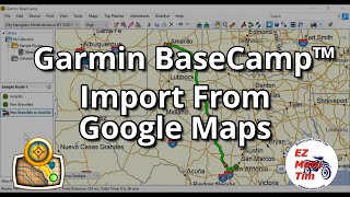
9. Open Base Camp with your Navigator plugged in, make a New List and name. Drag and drop the KML file into that New List.
10. It appears as a Track and Change the colour so you can see it better...Green best.
11. Change ACTIVITY to DIRECT
12. Top toolbar hit Basecamp Preferences, ADVANCED
13. Change Track Conversion Via points to approx 1 per every 4 miles CLOSE
14. Go back and hit the TRACK and Create Route from Track...straight helicopter lines.
15. Change activity to Motorcycling and it is good to check each via point and move if off position, especially roundabouts.
16. Transfer to device and export if you need a gpx file to send to mates


![Google My Maps route planner [step-by-step tutorial]](http://i.ytimg.com/vi/IMmNkQu-4ZA/mqdefault.jpg)


![ARGENTINA vs. BOLIVIA [6-0] | RESUMEN | ELIMINATORIAS SUDAMERICANAS | FECHA 10](http://i.ytimg.com/vi/C3wPtKNbAOA/mqdefault.jpg)

