My dad taught me this waaaay back in the Boy Scouts for our land navigation training. He served in Vietnam, and his entire job was using maps to coordinate artillery fire. He taught me so much stuff, including navigating at sea. He's still around, 79-years-old, and when I told him I'd be driving from Tri Cities, WA to Nashville, TN for my move this year, he couldn't help want to assist in plotting my route, just like we used to do all those years ago on family road trips. Navigation is such an useful skill, and my dad also tells me that's what a father is all about; being a lighthouse, a guide who won't tell you where to go, but rather help you know where not to go. We all have our own journey, and while our paths cross, a good person helps you avoid the pot holes.
Dave, thanks so very much for this. This technique is the exact way I was taught when I took the Map, Compass, and Survival Course put on by the MA Dept. of Wildlife back in around ‘86 or ‘87 when I was about 14. My dumb ass lost the hand outs and manual for the course so I could never remember how this was done. I aced this course at such a young age, because this is the easiest, by far, method of orienteering from known point, to known point there is, at least for me. Thanks again.
I did a short three mile hike in Rock Creek Park (Washington DC) today using a compass and this clip breaking down the basics really helped me. Thanks Dave!
This is my favorite way of orienteering with a map. It is so simple, quick and easy, and combine it with catching features and handrails it is pretty much foolproof.
The Sunto compass really has a ton a great features. It’s great to be able to set the declination and then not have to do all the calculations. I still think it is worthwhile though to learn how to use a Camenga simply for the fact that the Sunto is plastic and can get damaged. I keep a Camenga in my pack as backup, and that really gives me peace of mind. While it lacks the simplicity and convenience of the Sunto, it makes up for it in durability. The Camenga is practically indestructible. I have the Sunto with the Global needle; I’ve heard reports that the Sunto compasses specific to only the Northern or Southern Hemisphere, respectively, sometimes have issues with the needle getting stuck, but I haven’t examined this myself. Just something to keep in mind. If anyone can confirm this, I would appreciate it
It is possible to use a Camenga compass in the same way without a protractor. Place it between point A and B and use it as a base compass. Some orient the map before which is not necessary. Orienting the map is only necessary when you compare the map with reality. The downside of the Camenga compass is that the smallest step on the bessel ring is 3 degrees.
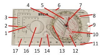
The Silva Method, which includes the Silva 123 technique of using the inner meridian lines, was developed in the 1950s by José Silva. So, it's been around for over half a century, evolving and adapting over time. Using the magnetic needle to obtain a map azimuth must be a technique taught in boy scouts etc. This can be dangerous technique as magnetic interference can result in skewed azimuths. The map must be secure in order to obtain an accurate azmith. I believe the military uses a protractor for this reason as well as the Commenga has no inner meridian lines to align with the Eastings of the map. Note that the rotating bezel line on a Commenga military compass can be used similar to the Silva 123 method. The bezel line can be closely approximated to map North. You point the rotating bezel line N then rotate the compass until the magnetic needle is under the bezel line. Under the Index Line (black line of the compass) will be your grid azimuth. Declination must then be factored. This technique can be used "on the fly" and will be close to being accurate. Perhaps Dave can show this technique outside of this series in case someone breaks or loses their protractor while using a military compass. There is also a bezel click technique to adjust for declination. Left to adjust for Westerly declination and right for Easterly. Each click is three degrees so you may be out a degree using this technique.
I would say you misinterpreted something the map is grid north but laying on the table facing south, which makes no difference in this exercise azimuth was east and needle orientation was correct


My dad taught me this waaaay back in the Boy Scouts for our land navigation training.
He served in Vietnam, and his entire job was using maps to coordinate artillery fire. He taught me so much stuff, including navigating at sea. He's still around, 79-years-old, and when I told him I'd be driving from Tri Cities, WA to Nashville, TN for my move this year, he couldn't help want to assist in plotting my route, just like we used to do all those years ago on family road trips.
Navigation is such an useful skill, and my dad also tells me that's what a father is all about; being a lighthouse, a guide who won't tell you where to go, but rather help you know where not to go. We all have our own journey, and while our paths cross, a good person helps you avoid the pot holes.
The Map Reading Company teaches this, also. Good presentation of the technique Mr. Canterbury.
Dave, thanks so very much for this. This technique is the exact way I was taught when I took the Map, Compass, and Survival Course put on by the MA Dept. of Wildlife back in around ‘86 or ‘87 when I was about 14. My dumb ass lost the hand outs and manual for the course so I could never remember how this was done. I aced this course at such a young age, because this is the easiest, by far, method of orienteering from known point, to known point there is, at least for me. Thanks again.
I did a short three mile hike in Rock Creek Park (Washington DC) today using a compass and this clip breaking down the basics really helped me. Thanks Dave!
Short and sweet. Great video with important info. Thank you Dave.
This is my favorite way of orienteering with a map. It is so simple, quick and easy, and combine it with catching features and handrails it is pretty much foolproof.
Love this series brother, thank you!
This is similar to how a Breton plotter works. Excellent demo Dave.
We use this technique in mountain rescue teams
Dave is the King
Thanks again for all the great content.
The Sunto compass really has a ton a great features. It’s great to be able to set the declination and then not have to do all the calculations. I still think it is worthwhile though to learn how to use a Camenga simply for the fact that the Sunto is plastic and can get damaged. I keep a Camenga in my pack as backup, and that really gives me peace of mind. While it lacks the simplicity and convenience of the Sunto, it makes up for it in durability. The Camenga is practically indestructible. I have the Sunto with the Global needle; I’ve heard reports that the Sunto compasses specific to only the Northern or Southern Hemisphere, respectively, sometimes have issues with the needle getting stuck, but I haven’t examined this myself. Just something to keep in mind. If anyone can confirm this, I would appreciate it
What a great piece of new info. Thanks man.
That's pretty slick! Great series, will definitely mark this for future review.
Thanks Dave
Great tip!
Gr8 vid. I'd like to know where you found that compass?
Thank you 😇👍🙏
Killing it with these videos!
This is so baddass! I'm gonna do this tomorrow and find something cool to explore in my area!
Great information. thanks for sharing.
It is possible to use a Camenga compass in the same way without a protractor. Place it between point A and B and use it as a base compass. Some orient the map before which is not necessary. Orienting the map is only necessary when you compare the map with reality. The downside of the Camenga compass is that the smallest step on the bessel ring is 3 degrees.
Your awesome brother👊🏼
Love it
The Silva Method, which includes the Silva 123 technique of using the inner meridian lines, was developed in the 1950s by José Silva. So, it's been around for over half a century, evolving and adapting over time.
Using the magnetic needle to obtain a map azimuth must be a technique taught in boy scouts etc. This can be dangerous technique as magnetic interference can result in skewed azimuths. The map must be secure in order to obtain an accurate azmith. I believe the military uses a protractor for this reason as well as the Commenga has no inner meridian lines to align with the Eastings of the map. Note that the rotating bezel line on a Commenga military compass can be used similar to the Silva 123 method. The bezel line can be closely approximated to map North. You point the rotating bezel line N then rotate the compass until the magnetic needle is under the bezel line. Under the Index Line (black line of the compass) will be your grid azimuth. Declination must then be factored. This technique can be used "on the fly" and will be close to being accurate.
Perhaps Dave can show this technique outside of this series in case someone breaks or loses their protractor while using a military compass.
There is also a bezel click technique to adjust for declination. Left to adjust for Westerly declination and right for Easterly. Each click is three degrees so you may be out a degree using this technique.
Thanks!
Nice.
priceless. ty
Why did it look like your compass was pointing your direction to the West when you housed the needle when your destination was to the East
I would say you misinterpreted something the map is grid north but laying on the table facing south, which makes no difference in this exercise azimuth was east and needle orientation was correct
They teavh this stuff in aviation school.