It’s simply not possible to do it. That gimbal already struggles a bit with the heavier weight of the iPhone 13 Pro (which has a stainless steel housing, hence the extra weight). The added size and weight of the iPhone + rtk would make it impossible, unfortunately.
Top quality content as always. I am wondering what would be the output if the RTK correction and the gimbal used together for collecting LiDAR data from the iPhone?
Polycam App update - Used this now for a few building trials and it processes large building scans well. When purchasing the full APP (monthly pas as you need) it converts the 3D scan into Autocad dxf and other industry standard file formats very well. The only issue I have experienced is determining the exact point for the corner of buildings. I will look to use larger ground targets with site dimensions to triangulate and set actual corners, so hoping larger ground targets that can be clearly identified once uploaded into the CAD software will be the way to go. Otherwise, Polcam has worked very well.
That would be interesting to see the results/the way of combined total station and lidar survey. When the point cloud from iPhone is refined and net adjusted with the total station points.
@@RamiTamimi oh that’s right. We know it would improve the results to some degree, I was just curious if it would be a drastic improvement. Judging from the non-RTK run it seems like it would have a pretty decent impact. I would let you borrow my Gremsy if you were a bit closer. But I think you illustrated the point well enough.
I see your nearest mountpoint was 193 miles away on the screenshot, is that what was used? Also, why not put the viDOC on the gimbal and then test that? Weight? It seems that having a mount point within reasonable distance and the gimbal would provide significantly better results.
Hi Rami , Ive geared up with the iphone 13 pro and done a couple of test jobs . I'm currently using Recon3D and importing the las files into Autocad Civil 3D . What is your recommendation for the most suitable iphone application for the stitching of up to 8 scans on a residential allotment detail survey ?. As a consulting surveyor , I enjoy your videos and the way you examine and utilize new technologies.
0:27 No, the accelerometer can not measure speed and is not used to measure speed. It can only sense the (rate of) change of the speed aka. the acceleration (hence the name accelerometer).
Currently using LiDAR with Polycam to capture large commercial buildings. I found that 3D Scanner App couldn't handle large building scans and kept crashing when trying to process. Polycam seems to process captured data very quickly although haven't purchased the full App yet.
Any thoughts on accuracy when the model is produced from images beyond the LIDAR range? I have been able to get impressive capture of sloped roofs when I scan in a wide circle around a house. The iPhone lidar appears to be limited to about 15 feet and it looks like the images are being processed mainly from a photogrammetry perspective. The details of the facades are less crisp in the point cloud, but the majority of the roof gets documented. I tried doing a scan with 2 laps where I start out close to get good lidar coverage up close then expand the capture circle on the second lap. More often than not I get significant misalignments using this method. unfortunately, I don't have access to software that will allow me to create manual tie points to bring multiple models together. I am using a gimbal, which definitely helps, but I don't have access to an RTK device.
I understand that the error relative to the total station can be 1 to 3 cm, but, if I am not relating the measurement to control, how accurate is it? I am working on a site where I would like to create a heat map of surface regularity. The floor has to be plus minus 5mm. The floor level is of course important, but would this lydar scanner on the iPhone be accurate enough to create a cloud point terrain model of the surface?
Rami - could you draw a floorplan of a house using an iphone 13 with an RTK antennae attached by measuring the gnss location of each corner (inside and outside) of a house. Example: the house is a ranch style with 8 or more corners. Could you determine the location of each corner and feed the data into a program that would draw a line from each location to the next thus creating a floorplan sketch accurate enough for an appraiser to determine the gross living area of the house?
Not sure how well RTK works inside buildings since most RTK base stations are compensating for open air errors and not the error introduced from the building and whatever attenuation and reflections that might introduce. Probably better than none RTK GPS, but worse than open air RTK.
After seen all videos, I’m disappointed that this lidar apps on IPhones are not compatible to EMLID GNSS recivers or eny other GPS HARDWARE to connect to iPhones as external gps to collect data using this lidar applications in RTK, forcing us to buy this viDoc RTK that don’t see any use for it as a land surveyor and spend $5000 dls just to use it ONY for this applications
Interesting comparisons. I see the vidoc as an rtk correction but are there others that can do this job? The vidoc being the best part of 5k. Would you in theory be able to use the sparkfun facet or sparkfun rover to connect to the iPhone via Bluetooth on the rtk correction as a more affordable alternative? Also would be interested if you have any advice on data capture techniques to aid in best possible accuracy collection.


I’m surveyor from Ethiopia. I appreciate you what you are doing 👍
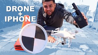
Can you use the gimbal and the rtk at the same time. Thanks for info
It’s simply not possible to do it. That gimbal already struggles a bit with the heavier weight of the iPhone 13 Pro (which has a stainless steel housing, hence the extra weight). The added size and weight of the iPhone + rtk would make it impossible, unfortunately.
I would need a bigger gimbal since the weight of the RTK device is heavy
Greetings from Argentina, with a DJI ronin it is possible, do you think you can get one to do some tests?
@@RamiTamimi if you did that it actually might be the most accurate solutions overall
This guys is an Amazing Teacher!!
You're the best teacher a big hug from Perú...
Tried the RTK with a gimbal? I’m looking at a zhyun crane m3 combined with the RTK
Top quality content as always. I am wondering what would be the output if the RTK correction and the gimbal used together for collecting LiDAR data from the iPhone?
Polycam App update - Used this now for a few building trials and it processes large building scans well. When purchasing the full APP (monthly pas as you need) it converts the 3D scan into Autocad dxf and other industry standard file formats very well. The only issue I have experienced is determining the exact point for the corner of buildings. I will look to use larger ground targets with site dimensions to triangulate and set actual corners, so hoping larger ground targets that can be clearly identified once uploaded into the CAD software will be the way to go. Otherwise, Polcam has worked very well.
As always, the Quality and Value of your Content is unreal. We love the Vidoc! Thanks Rami.
That would be interesting to see the results/the way of combined total station and lidar survey. When the point cloud from iPhone is refined and net adjusted with the total station points.
The accelerometer is used to calculate phone orientation not speed. The giroscope is used to calculate rotation speed not orientation.
Another great deep dive, thank you for sharing!
I would’ve been curious to see you add the gimbal back on after adding the RTK.
I was thinking the same
I would need a bigger gimbal since the weight of the RTK device is heavy
@@RamiTamimi oh that’s right. We know it would improve the results to some degree, I was just curious if it would be a drastic improvement. Judging from the non-RTK run it seems like it would have a pretty decent impact. I would let you borrow my Gremsy if you were a bit closer. But I think you illustrated the point well enough.
Great content mate! I viable scan a relative large section of road with iphone? Regards from Paraguay!
What about using an Ipad, does it hase the same technology of the Iphone? Can be uses with a gimbal as well?
I see your nearest mountpoint was 193 miles away on the screenshot, is that what was used? Also, why not put the viDOC on the gimbal and then test that? Weight? It seems that having a mount point within reasonable distance and the gimbal would provide significantly better results.
Is it possible to 3D scan tyre marks on soil and then measuring complex measurements on them? for forensic purpose.
Hi Rami , Ive geared up with the iphone 13 pro and done a couple of test jobs . I'm currently using Recon3D and importing the las files into Autocad Civil 3D . What is your recommendation for the most suitable iphone application for the stitching of up to 8 scans on a residential allotment detail survey ?. As a consulting surveyor , I enjoy your videos and the way you examine and utilize new technologies.
0:27 No, the accelerometer can not measure speed and is not used to measure speed. It can only sense the (rate of) change of the speed aka. the acceleration (hence the name accelerometer).
Great content for surveyors.
Any recommendations on a good dual band gps phone?
Either a midrange 2022 phone or a flagship that is about 2 yrs old (cant afford new flagship)
Excellent video man. Learned a lot.
Currently using LiDAR with Polycam to capture large commercial buildings. I found that 3D Scanner App couldn't handle large building scans and kept crashing when trying to process. Polycam seems to process captured data very quickly although haven't purchased the full App yet.
Sir, can we distribute 9 cm error by RMSE method.
Congratulations on the work.
Maybe it would be interesting to compare accuracy of iPhone Lidar vs photogrammetry. What is more accurate. When you survey your house.
Any thoughts on accuracy when the model is produced from images beyond the LIDAR range? I have been able to get impressive capture of sloped roofs when I scan in a wide circle around a house. The iPhone lidar appears to be limited to about 15 feet and it looks like the images are being processed mainly from a photogrammetry perspective. The details of the facades are less crisp in the point cloud, but the majority of the roof gets documented. I tried doing a scan with 2 laps where I start out close to get good lidar coverage up close then expand the capture circle on the second lap. More often than not I get significant misalignments using this method. unfortunately, I don't have access to software that will allow me to create manual tie points to bring multiple models together. I am using a gimbal, which definitely helps, but I don't have access to an RTK device.
If you are measuring 200.5 backsight, your total stations’s coordinate should be 4799.5?
I understand that the error relative to the total station can be 1 to 3 cm, but, if I am not relating the measurement to control, how accurate is it? I am working on a site where I would like to create a heat map of surface regularity. The floor has to be plus minus 5mm. The floor level is of course important, but would this lydar scanner on the iPhone be accurate enough to create a cloud point terrain model of the surface?
I don't think it would be applicable. I need a total station or 3d Laser scanner don't I?
Can Iphone be used with prism to get measurements -- A B Quadri -- India
Now Gimbal + RTK??
Rami - could you draw a floorplan of a house using an iphone 13 with an RTK antennae attached by measuring the gnss location of each corner (inside and outside) of a house. Example: the house is a ranch style with 8 or more corners. Could you determine the location of each corner and feed the data into a program that would draw a line from each location to the next thus creating a floorplan sketch accurate enough for an appraiser to determine the gross living area of the house?
Not sure how well RTK works inside buildings since most RTK base stations are compensating for open air errors and not the error introduced from the building and whatever attenuation and reflections that might introduce. Probably better than none RTK GPS, but worse than open air RTK.
Where do I get the Gimbal and vidox antenna to purchase
I am not convinced by ViDOC, either here or in the earlier drone video.
Neither am I... 10cm deviation at 60cm for this price... I was expecting something in the range of 3cm...
Are you from yemen
How much?
surveying not in metric sounds soo wrong ^^
Haha, welcome to America.
Where are you from?
Use the vidock with the gimbal
Great videos..but the vidoc is too expensive to me
Very valuable information. Thank you so much
After seen all videos, I’m disappointed that this lidar apps on IPhones are not compatible to EMLID GNSS recivers or eny other GPS HARDWARE to connect to iPhones as external gps to collect data using this lidar applications in RTK, forcing us to buy this viDoc RTK that don’t see any use for it as a land surveyor and spend $5000 dls just to use it ONY for this applications
جزاك الله كل خير
Interesting comparisons. I see the vidoc as an rtk correction but are there others that can do this job? The vidoc being the best part of 5k. Would you in theory be able to use the sparkfun facet or sparkfun rover to connect to the iPhone via Bluetooth on the rtk correction as a more affordable alternative?
Also would be interested if you have any advice on data capture techniques to aid in best possible accuracy collection.
Kickthemap HAx Is another option
You still haven’t tried the vidoc with the gimbal?….
I would need a bigger gimbal since the weight of the RTK device is heavy
Ótimo vídeo!!! Obrigado pela informação!!!!
What about RTK plus gimbal?
I would need a bigger gimbal since the weight of the RTK device is heavy
@@RamiTamimi You can do it! Get a grant
Everyone: Just use metric!
America: 1+10ft
I’m from Brazil!!! Sorry!!!