Haha, I love the NYC subway map (as I'm sure is obvious from my background decorations). Would definitely be up for Manila content even though it'd be a little off-brand!
There’s an argument to be made that PATH trains should not only stay on the map, but also that they should be indicated in the same style as subways. Although PATH trains are run by a different agency, they’re basically subways, which many New Yorkers, including myself until a few weeks ago, didn’t know.
As someone from Philadelphia, that would make sense, because the South Jersey train service PATCO is shown in the same style as the subway lines on the SEPTA map
I already knew that in the 1960s by use of the New York Telephone Directory that had a map of both systems. I am a New Yorker who grew up in NYC during the Mad Men era of the 1960s. 😊
@@royk.9347It is known as the Port Authority Trans Hudson subway. It is a subway system that connects Jersey City, Hoboken, Harrison and Newark N.J. to New York City via the Hudson River tunnels. It has 3 stations that are connected to 3 NYC subway stations on 6th Avenue.
I am a longtime New York City resident 65 years plus. It is very sad that all of the Subways in Queens and Brooklyn on a forced to go through Manhattan. Why do we have to go through Manhattan from Queens to get to Brooklyn. My mother may she rest in peace used to take the old Subway line direct link from Queens to Brooklyn back in the 1940s. That subway line has been shut down during WWII. And I have the subway map from 1940 to prove it. Mother would have been 98 if she was still alive. She rode the Subways when it was only $0.05
At 12:20 -- the reason all this information is on one map is because about 95% of the information is under the umbrella of one agency, viz., the MTA. The Metropolitan Transportation Authority is the agency that oversees NYC Subway, NYC buses, MTA, LIRR, the Staten Island Railway (SIR) and many (but not all) of the area bridges and tunnels. It's natural for them to combine all this information--and that's also why if you turn the paper map over to the back side, you'll see the MetroNorth and LIRR routes on a separate map.
I first became fascinated with the nyc subway maps when I was 8-9 years old in 2007. I managed to master it within a year to the point everyone would come to me to ask me for directions. I even still get asked by my friends and family although I now live in Texas 😂 My mom bought me the World Subway Maps for my birthday in 2009 and if I know I’m traveling to a specific city I always reference it. The reason why all those information is on the map is because it gives NYers an idea on what’s near it
Jitneys are traditional Indian transportation - a three-wheeled vehicle, and when the US Military occupied the Phillippines, they took Jeeps with them, so when Jeeps became converted for transit, they were called "Jeepney"
The most likely reason for the inclusion of LIRR and Metro-North information is that they, along with NY Transit, are under the umbrella of the MTA (Metropolitan Transportation Authority). NY State purchased the assets of the LIRR from the former Pennsylvania Railroad in 1965. In the convoluted history of railroad mergers that's too deep to go into here, the current entity that we know as Metro-North was born in 1983. It, too, it under the auspices of the MTA.
I grew up with the Vignelli map, and as a kid, I found it very easy to use to travel. The map that replaced it was a whole new universe to me, and I have to say, much more geographically accurate than the map that is used today. Some subway stations have modernized versions of the Vignelli map posted next to the local neighborhood maps.
I've used both the Vignelli and the current maps. Although the Vignelli design is vastly superior from a design or artistic perspective, it's a disaster for navigating the city--both for locals and for tourists. In one case, the Vignelli map had to dislocate one of the stations (near Columbus Circle) to keep the artistic integrity of the map. Imagine sacrificing accurate location and navigation for artistic design on a subway map! Try explaining that to a tourist--yeah, that subway station is really five blocks east of where it's shown on the map because the artist thought it looked better over there.
Just to clarify at 0:40, New York City (both the city proper as well as the metropolitan area) have always been and still are significantly larger than the respective sizes of Manila. What's vastly different is the land size, and so the population is much denser in Manila, even if the total number of people is not.
I remember before smartphones when everyone knew the exact technique for unfolding a subway map in a handheld way so you could references it while traveling without having to have it totally open.
@@brooklynnyc8457 It's been like 15 years since I've held a paper map so I don't remember the exact steps but I remember it being very similar to folding and holding a New York Times.
I grew up in Boston and was familiar with the MBTA subway and commuter rail maps which were basically schematics (they also had geographically accurate maps), so when I went on a school field trip to New York City I got a copy of the Vignelli New York City Subway map. It was a nice map to look at but one year when I was away at college and returned it was gone! 😭😢
I remember being obsessed with the physical MTA maps back in the early 2000s as a little kid. Because like you said there's so much extra stuff on it and I was trying to understand it, but at the time couldn't.
Lol I am glad you are saying something about this map. I lived in nyc all my life and we had a few lines on the map but we just knew where to go now it's so confusing I don't read the new subway maps. I just use my knowledge of the pass. Lol But now I am seeing new stations with different exits. I give up. Thank you
Years ago as a fist time visitor to NYC, I was by myself and picked up one of these maps. I liked it because I knew it had pretty much everything I would need to know, but I also knew it would take a bit of time for me to understand all of it. But until today there were still some things on the map that I didn't understand. Thanks for clarifying!
I have been a (paper) map nerd all my life. I always felt the NYC subway map was great as a reference but you need to just pay attention out in the wild. Things change quickly in NYC especially the aging subway. Great video.
That little, skinny line running from second avenue and East 60th Street to Roosevelt Island (5:51) is the Roosevelt Island Tramway, which is the first commuter aerial tramway in North America when it open in 1976. In its 47 years of service, the Tramway (or Tram for short) has transported over 26 million passengers. Although it is not part of the NYC Transit System, the Tram does accept the MetroCard. It will also soon accept the ONMY Card payment system. As for removing the line off the subway map. That will never happen, because the Tram is a vital link between the East Side of Manhattan and Roosevelt Island. The Tram is also a tourist draw.
The Vignelli map looks so different from any other subway map that NYC has ever had that the first time I saw it I thought it was only a novelty map rather than an official map at one point.
Sbi na pinay eh! Hi Kabayan, salamat sa mga videos mo, been binge watching them, heading to NYC in a week, will be using your NYC guide/ planner videos, kudos and love your videos!😊
The Vignelli map had a ton of issues it wasn't just people tripping over things not being to scale. For starters, it distorted things in ways that would be fine in an old style European city, but are extremely misleading on a grid city. It implied that certain stations were on the same avenue when they weren't, or that one was on the other side of a line when it wasn't. The thing about "abstracting" away geographical information is that in a grid city that information is already compressed, so you don't really need to hide it. That's what makes the background geography useful in the map, it tells you just enough to guess which way the grid faces and which streets are major, but its subtle enough to not be in the way. The other, far more significant problem with Vignelli is his insistence that each and every service variation gets its own line with its own color and it should be maximally different from the ones it runs with. That idea falls apart with the way the subway is laid out. You end up with impossible to follow rainbow spaghetti in midtown. The present map literally assigns colors based on which trunk the line uses in midtown precisely to avoid confusion in the most tangled section. The fact that the Vignelli map failed but designers are still praising it as the "better" map speaks to a certain arrogance. There's this refusal to learn the lessons of why it failed. The present map has issues and inconsistencies too. Tarmac (one of the original designers of it) has a lot to say about the slow accumulation of issues on it with every update. Hertz had some salty comments too before he died. But all things considered, the design they came up with has stayed up 40 years. Its good design, even if its not pretty.
Neat video! Love to see content about transit & design. I actually find it useful to see where the commuter trains lines are - then you can follow the tracks to find for example where the next nearest station might be - esp. because the LIRR has two branches you could end up on the wrong branch without realizing if you’re just looking for LIRR stops
That said when I first moved to New York over a decade ago I got lost all the time before I got familiar with the geography and the transit lines 😂 I understand the desire for simplicity!
& yes absolutely the commuter ferry lines should be included - they might not run often enough to be super practical for getting around but they still are a viable mode to get places and a very cheap way to see the city from the river.
The new experimental map you mentioned still exists in some stations throughout the city! I’ve seen it in crown heights, yorkville, and even the shuttle to grand central!
I read an interesting article recently about maps in general, which discussed a factor that you named briefly: politics. Smaller cities and neighborhoods lobby map makers to include their communities, or to feature them in larger & bolder type. Commercial businesses hope to be included. Business districts (think "theater district", "Little Italy" etc) hope to be highlighted. Politicians hope to feature anything or anyone who help to keep them in office. There's nothing objective about any of it Thanks again for an informative video.
Great video, I love how you make them and the little anecdote at the beginning. then, I don’t know if you know but in France there is an application called MTA live map but I think it also exists in the United States and it is very good because it shows the individual metro lines and all together with a separation between the letters and numbers lines and there is a live view of the subway cars to know when they arrived
Growing up in Brooklyn, my mom taught me and my siblings how to get around. We never really got lost because we had most of central BK down pack. After 03, I needed to use a bus map from time to time. To be specific, the LI bus map. I used to work in Garden City LI .When I started driving, GPS on my phone was whack and I think I had pretty good phone back then from Sprint. I had to use a regular map to get around. lol
I think the Jeepneys of Manilla sound similar to the Jitneys of Nassau, Bahamas that NJB and FMIAFL covered. Also, NYC and NJ have Jitneys that Classy Whale covered
fascinating, i look at the map a lot even in the age of apps, and i have never ever thought the map was Bad, or at least, chock full of unnecessary information. like thanks to looking at the map so often, i know where pretty much everything is, even if i rarely use the lines. google maps just added a custom MTA bullet for subway stations on top of tracing the lines as they run on a real, to-scale map, which i like to look at more. i heard they're coming out with a new MTA app which is exciting! there were so many instances in my youth, where i would look at the subway map to gauge the distance i had to walk somewhere. and it was a bad time! like walking from one M terminus to the other LOL. also i wasn't caught up on the channel lore! congratulations on the braces coming off 🥳
Hey Thea! I love your helpful videos. I'm curious what programs you use to make your graphics, and what's your graphic design experience? I'd imagine you've been doing graphic design professionally for a while now, as wonderful as your designs are. I'm looking to get into the trade and would love to get more info on your process. Thanks Thea!
Thanks! I mostly use Illustrator and Photoshop for graphics. And yes, I worked as a designer for a long time before YouTubing. Best advice I can give is to take advantage of all the resources out there. So many great RUclips channels for learning!
I've actually seen the new map in the wild in a couple of spots. Its on the Grand Central-Times Sq shuttle and at least one wall on the 149th Grand Concourse station. I'm sure there are other places, but those are the only two I can remember seeing.
I grew up in an european city with 3 subway, 6 tramway and a handful suburban lines on the transportation map. It’s comparatively small, but was big enough to feel comfortable with the NYC Subway map right away. I would feel insulted and treated like a stupid child if the map wouldn’t show commuter rail or ferries at all.
I've been to manila and the philippines before and the way transportation worked confused the hell out of me haha when my family knew where to go and how to get around confused me
The answer to you question about the map is that NYers want things that work and the subway map does that. Those of us who grew up here understand the geography and relate to it. The map does that.If it is pretty or works, works always wins. The vast number of NYers live in the "Outer Boroughs" and streets, etc. are not quite as simple as Manhattan so these maps are helpful. Also the population of the city is about 8.5 mil and the metro region is about 23 million. Also because so much of the out of city areas are train related and it is handy to know where one can pick up a commuter train and this map shows that. If I want to visit my relatives out "on the Island" at a specific place this map will show me how to get to the LIRR station. It is a very handy map for those reasons. Maybe that is why NYers want it. Nice research though.
"Once I'm on the LIRR I tend to just use the map for the LIRR" Sounds like a self-contradiction with your statement about three subway operators with separate maps being unwieldy. I'm not sure if you noticed this, but if you start your journey on say a letter line, you can reach most important destinations without transferring to a number line. This is because cross-platform transfers between lines of the same division are easy (think letter to letter, or number to number), and both divisions tend to service the same destinations, just a block apart in manhattan (think about the sixth ave line vs the seventh ave line). Therefore, most passengers would probably stick to one division for most journeys, unless they were going from one outer borough neighborhood to another outer borough neighborhood.
It makes a lot of sense to me to have all that information on the map (full disclosure: I'm not from NYC or even the US, but use public transit a lot everywhere), because I look at it not as a 'subway map' but a 'rapid transit' map. I want to get from somewhere to somewhere and I want my options, be it subway, commuter rail, etc. But I see your point. Also: couldn't agree more with the decision-makers back in the day when they decided they wanted a geographical map. I hate schematic maps, they're misleading and bad to look at (even if I see the advantage they present in terms of layout).
I thought it was there so in the event of a subway disruption people could consult the map and see if commuter rail can assist you in getting you somewhere.
I knew you were filipino! ❤ When I was in Cebu City, I had to learn how to take the jeepneys there. It was very confusing, and the only way to learn was word of mouth through friends. Now in New York, the information is all app-based and real-time.
That’s why I like Transport for London, you can get either a basic tube map that shows DLR & Overground too (which are self contained metro type services) and then you can get the other map with everything and anything on it
The crazy thing is, the tram WAS labeled in previous versions. Clearly, whoever was hired to edit the map clearly didn’t pay attention to what they were doing and the details and needs work on map making. There are multiple errors on the current versions of the map than that, too.
The jeepneys in Manila you described remind me of the Matatus in E. Africa (e.g. Nairobi, Kampala, etc.) Also Pittsburgh and some parts of far-Eastern Queens/LI/Brooklyn has jitneys/dollar vans that transport ppl on a route only fixed within ppls minds rather than a formal map lol
I grew up with the NYC subway map. I’m bias. So when I see other subway maps, like the Boston Metro… it kinda ticked me off how they use the same color for a different route entirely. And the lack of detail on other map ahhh. What worst took a Cartography class so it pains me even more.
We have things similar to Jeepneys in Caracas but we call them "por puestos" they're like small buses and they also do not have concrete stops but rather a route.
and the directions are also similar lol we don't have door numbers and our "post codes" are next to useless. My bf was always very confused since he is British and post codes in the UK are quite precise.
Hey! Unrelated question: would you recommend an app or actual prepaid sim card to have a US number and use apps like Revel, Seated, etc that won't take many or most country codes? Thanks!
I've been in a position to assemble timetables and maps for public transportation. As long as politicians and others are involved the more items that have to be shown as someone either official or customer will complain.
A lot of non-subway information is on the subway map because in the heyday of paper maps, subway maps were used for far more than just the subway! Often you might carry one with you everywhere and no other map, and of course they were free at stations; even today, people use the subway+buses to get to MNR/LIRR stations, so their presence makes sense, they're part of the same transit system (despite separate fare structures and rules). Re your @9:25, "Sometimes I have a hard time just using my small cell phone, let alone 3 subway maps that you fold and unfold" - I THINK YOU'D BE SURPRISED! You might actually find it EASIER to unfold a single large subway map and use it for navigation and wayfinding than scrolling on a cell phone. It is, of course, a skill, and one that a lot of people have never learned in era of smartphones. But it's kind of like reading a broadsheet newspaper on the subway. I really like the NYC subway map, and disagree with you that "designers" hate the idea of using subtle cues like font serifs to distinguish neighborhoods from landmarks. One of the effective things the map does is to subdue the non-critical information in lighter colors and backgrounds so if you don't need it, it doesn't get in the way.
Whether for driving or riding the subway, actual maps (paper or on line) are useful to show a fuller context than just reading GPS directions off your phone. I like to know where I'm starting, what I'm passing through, and where I'm ending in one image. Lose your phone service, and you will be completely lost. Your historical maps were great!
That current NYC Subway map is like the Webster's dictionary, you can have abriidged or unabridged. Boston has a map similar to NYCs, except the map is spatially distorted, to allow for typing in all the light rail stops, especially. The MBTA map also has key bus lines and commuter rail stations and lines and the Silver Line BRT system. They also had a map with just the Rapid Transit and Light Rai lines, which was small to be a trifold card, smaller than a trifold wallet. As for Manila, you must e a Filipino or really earned the language to understand where the Jeepneys are going or to use the trikes, back before smsmartphones and Google Translate.
I have heard, *so*many*times*, how the MBTA subway map has distorted people's ideas of Boston geography in horrible ways, resulting in them learning only years later how close and far away things really are. That happened to me, too, although not in the crazy way of some stories, like, people taking the T for an hour to go between places that are a 15 minute walk. There's a real cost to omission of geography!
QUESTION: Thea, I love all your videos. I was wondering, though, if you have ever done one on how streets in Manhattan are numbered. I know there's some formula that can be used to figure out what the cross-street for a particular address is, but why does there need to be a formula? Why is the Wintergarden Theatre's address 1634 Broadway when it's nowhere near 16th Av or even 160th Av? It's between 50th and 51st! Thanks to you I now have an understanding of addresses in Queens, but could you please help me with addresses on Manhattan streets. Thank you 🙂
My earliest videos are actually on the Manhattan grid. Part 1: ruclips.net/video/Wv2L6oe9pAA/видео.html Part 2: ruclips.net/video/4YiqZdk0c8Q/видео.html
Atlantic City Jitneys are private-owned vehicles that run on Pacific Avenue (the major street parralel and closest to the beach). NJ Transit buses run on Atlantic Avenue, a block farther from the beach.
I feel the NYC Subway map is just not very useful. With a proper line diagram transfers and routes are much easier to find. To find start and end point you need detail maps anyways.
I like the NYC transit map much more than cities that just show straight lines for trains. People praise the design of the London tube map, for instance, but it's useless for actually showing where the stations are in relation to other things. Showing the water, parks, and major streets helps with that. I also don't mind having the commuter lines on the map. If you're going to or from the outer boroughs, it can often be more efficient to take a commuter train than the subway, and it's good to know where the various lines are in relation to each other. The Statue of Liberty ferry probably is a bit excessive. A large part of the audience for this map is tourists, though, and showing that ferry is really not much different than showing other landmarks.
The worst part about the NYC Subway map is that all the service patterns are drawn with a single line. A line that splits into three directions on one side and 2 on the other side and also has rush hour and express service? Super hard to visualize if you don't put every service as a seperate line on the map. Maps like the KickMap are therefore much much easier to understand for someone who is looking for information on how to get somewhere and is not 100% familiar with the system (the intended user of a map in the first place). That's an issue beyond just style (having landmarks on the map). Therefore this map is one of the worst transit maps for any major city in the world because it fails at its most core purpose.
As Jay Foreman said "Most other subway maps followed in Beck's footsteps except for the New York subway which insists on being as baffling and ugly as possible."
I laughed at your reference to the person who believes Helvetica contains the cure to cancer. I know people like that! Personally I think Comic Sans hold he cure to cancer but most people diss it because it is so frivolous. You know that thing about first impressions. Have a good day!
Almost 5 minute of intro in a 15min video? It's too long IMO. Regarding the map, I think commuter rails or conventional railways and other public transit info should be on it since it's a map that is supposed to help people connect. Like what's said in the video, they are in muted colors so the focus is still the subway system. Official Tokyo Metro Subway map also shows JR lines and other private rail lines, for instance.
Thank you for your presentation. Manila is fascinating. There are pros and cons to any mapping scheme, and while I appreciate your point of view, I want to expose you to someone else who also does great design. The New York City map is "busy" but it is great design - the minimalist design typified by Jony Ive's work at Apple doesn't work well for everything. Knowing the coverage of the commuter rails is important not just to "some people," but to a lot of people, and not just to tourists - to business people too. I recommend you read Edward Tufte's books: THE VISUAL DISPLAY OF QUANTITATIVE INFORMATION and ENVISIONING INFORMATION would be useful to showing you why busy maps can be very valuable. I will also post here Joseph Brennan's integrated transit map, which includes New Jersey. The New York City subway map is not merely the result of a few people's purely parochial interests, or because someone watched a movie. It is a product of consensus about the most useful way to present transit information. That consensus can change of course. I offer you my encouragement.
The subway map is not easy to use. It requires some studying to figure out what is going on and how it works. Once you understand it, you don't need it anymore. Either you'll memorize your commute or common places or your will use the apps to get you to new destinations. Station navigation, that's a different story.
Subway MAP. You see what i did there? It's a map, with the subway the lines. Not some designer garbage. Why are the commuter trains on there? So people who ride them or may ride them know where they are in relation to the subway. So people can figure which subway they can take and then walk to the commuter station. They are also clearly labeled different and more done so in such a way if you're not looking for them you won't even notice them. Not everyone takes a subway that has a direct connection to the commuter trains. And some don't have the option at all. Harlem line for example. Let's "design" some stupid "map" that isn't even actually a map that actually sucks as a map but looks "pretty" and simple and something a graphic designer would celebrate!
I prefer the geographical map. And maps that include the metro AND the trains, so I can plan a route with the two in mind. That being said, the geographical map just needs to fix the inconsistencies that you mentioned. For example, if the touristic ferris are included, why not included its stops. Or why not include the commuter ferris. And the different train operators should be indicated with a different color. Etc, etc
I much prefer the cleaner style for subway maps, similar to London's and São Paulo's maps for their train systems, even if it means that distances are skewed.


![Seungmin "그렇게, 천천히, 우리(As we are)" | [Stray Kids : SKZ-PLAYER]](http://i.ytimg.com/vi/kAzmhLHePqU/mqdefault.jpg)

Really cool video, I enjoy it
Haha, I love the NYC subway map (as I'm sure is obvious from my background decorations). Would definitely be up for Manila content even though it'd be a little off-brand!
103 likes and no replys? lemme fix that.
Native NYer and I love the NYC Subway map!
I like the current NYC Subway map better than the 1974 Subway map.
There’s an argument to be made that PATH trains should not only stay on the map, but also that they should be indicated in the same style as subways. Although PATH trains are run by a different agency, they’re basically subways, which many New Yorkers, including myself until a few weeks ago, didn’t know.
As someone from Philadelphia, that would make sense, because the South Jersey train service PATCO is shown in the same style as the subway lines on the SEPTA map
The big issue with that is that it might convince people there’s a free transfer 😔
Wat's a path train
I already knew that in the 1960s by use of the New York Telephone Directory that had a map of both systems. I am a New Yorker who grew up in NYC during the Mad Men era of the 1960s. 😊
@@royk.9347It is known as the Port Authority Trans Hudson subway. It is a subway system that connects Jersey City, Hoboken, Harrison and Newark N.J. to New York City via the Hudson River tunnels. It has 3 stations that are connected to 3 NYC subway stations on 6th Avenue.
I am a longtime New York City resident 65 years plus. It is very sad that all of the Subways in Queens and Brooklyn on a forced to go through Manhattan. Why do we have to go through Manhattan from Queens to get to Brooklyn. My mother may she rest in peace used to take the old Subway line direct link from Queens to Brooklyn back in the 1940s. That subway line has been shut down during WWII. And I have the subway map from 1940 to prove it. Mother would have been 98 if she was still alive. She rode the Subways when it was only $0.05
Personally I love the detail. Connections to other forms of transit are important.
At 12:20 -- the reason all this information is on one map is because about 95% of the information is under the umbrella of one agency, viz., the MTA. The Metropolitan Transportation Authority is the agency that oversees NYC Subway, NYC buses, MTA, LIRR, the Staten Island Railway (SIR) and many (but not all) of the area bridges and tunnels. It's natural for them to combine all this information--and that's also why if you turn the paper map over to the back side, you'll see the MetroNorth and LIRR routes on a separate map.
I first became fascinated with the nyc subway maps when I was 8-9 years old in 2007. I managed to master it within a year to the point everyone would come to me to ask me for directions. I even still get asked by my friends and family although I now live in Texas 😂 My mom bought me the World Subway Maps for my birthday in 2009 and if I know I’m traveling to a specific city I always reference it.
The reason why all those information is on the map is because it gives NYers an idea on what’s near it
You make me feel old 😒
Half Filipino living here in NYC -- great to see your channel grow!
AS A TOURIST I LOVE THIS map, is the only one i got, so everytime i went to nyc i feel like home .. and i never got lost thnks to this.
Jitneys are traditional Indian transportation - a three-wheeled vehicle, and when the US Military occupied the Phillippines, they took Jeeps with them, so when Jeeps became converted for transit, they were called "Jeepney"
Cool fact! I didn't know that.
The most likely reason for the inclusion of LIRR and Metro-North information is that they, along with NY Transit, are under the umbrella of the MTA (Metropolitan Transportation Authority). NY State purchased the assets of the LIRR from the former Pennsylvania Railroad in 1965. In the convoluted history of railroad mergers that's too deep to go into here, the current entity that we know as Metro-North was born in 1983. It, too, it under the auspices of the MTA.
I grew up with the Vignelli map, and as a kid, I found it very easy to use to travel. The map that replaced it was a whole new universe to me, and I have to say, much more geographically accurate than the map that is used today.
Some subway stations have modernized versions of the Vignelli map posted next to the local neighborhood maps.
I've used both the Vignelli and the current maps. Although the Vignelli design is vastly superior from a design or artistic perspective, it's a disaster for navigating the city--both for locals and for tourists. In one case, the Vignelli map had to dislocate one of the stations (near Columbus Circle) to keep the artistic integrity of the map. Imagine sacrificing accurate location and navigation for artistic design on a subway map! Try explaining that to a tourist--yeah, that subway station is really five blocks east of where it's shown on the map because the artist thought it looked better over there.
As a person who doesn't live in New York, it took me much longer to understand the J and Z than everything else
Just to clarify at 0:40, New York City (both the city proper as well as the metropolitan area) have always been and still are significantly larger than the respective sizes of Manila. What's vastly different is the land size, and so the population is much denser in Manila, even if the total number of people is not.
I remember before smartphones when everyone knew the exact technique for unfolding a subway map in a handheld way so you could references it while traveling without having to have it totally open.
Why doesn't it surprise me that there are techniques for folding maps. 😂
How?
@@brooklynnyc8457 It's been like 15 years since I've held a paper map so I don't remember the exact steps but I remember it being very similar to folding and holding a New York Times.
I grew up in Boston and was familiar with the MBTA subway and commuter rail maps which were basically schematics (they also had geographically accurate maps), so when I went on a school field trip to New York City I got a copy of the Vignelli New York City Subway map. It was a nice map to look at but one year when I was away at college and returned it was gone! 😭😢
As someone who has Chinese ancestry I love seeing a fellow Asian on RUclips
I remember being obsessed with the physical MTA maps back in the early 2000s as a little kid. Because like you said there's so much extra stuff on it and I was trying to understand it, but at the time couldn't.
As someone who's used to using the London Tube map, the 1970s version looks a *lot* easier to use to me
Lol I am glad you are saying something about this map. I lived in nyc all my life and we had a few lines on the map but we just knew where to go now it's so confusing I don't read the new subway maps. I just use my knowledge of the pass. Lol But now I am seeing new stations with different exits. I give up. Thank you
Fun fact: At 5:51, that line was labeled with '"TRAMWAY" in the 2016 NYC subway map, but I guess they removed it in the later maps.
Can I pay for a ride on the Roosevelt Island Tramway with a NYC Metrocard?
> 5:45
Very informative video about the new york city subway! Thanks for sharing beautiful lady😘😘😘xox
Years ago as a fist time visitor to NYC, I was by myself and picked up one of these maps. I liked it because I knew it had pretty much everything I would need to know, but I also knew it would take a bit of time for me to understand all of it. But until today there were still some things on the map that I didn't understand. Thanks for clarifying!
Well done! Immense infrastructure and the way we relate to it are fascinating to me. I appreciate the comparison to the Philippines.
I have been a (paper) map nerd all my life. I always felt the NYC subway map was great as a reference but you need to just pay attention out in the wild. Things change quickly in NYC especially the aging subway. Great video.
That little, skinny line running from second avenue and East 60th Street to Roosevelt Island (5:51) is the Roosevelt Island Tramway, which is the first commuter aerial tramway in North America when it open in 1976. In its 47 years of service, the Tramway (or Tram for short) has transported over 26 million passengers.
Although it is not part of the NYC Transit System, the Tram does accept the MetroCard. It will also soon accept the ONMY Card payment system.
As for removing the line off the subway map. That will never happen, because the Tram is a vital link between the East Side of Manhattan and Roosevelt Island. The Tram is also a tourist draw.
FYI… the Roosevelt Tramway is marked on the map
Thanks for sharing about your courses!!! You are the best and I feel more calm after watching your content!
The Vignelli map looks so different from any other subway map that NYC has ever had that the first time I saw it I thought it was only a novelty map rather than an official map at one point.
It’s amazing how some people who have lived in NYC for years still can’t read a subway map.
Sbi na pinay eh! Hi Kabayan, salamat sa mga videos mo, been binge watching them, heading to NYC in a week, will be using your NYC guide/ planner videos, kudos and love your videos!😊
The Vignelli map had a ton of issues it wasn't just people tripping over things not being to scale.
For starters, it distorted things in ways that would be fine in an old style European city, but are extremely misleading on a grid city. It implied that certain stations were on the same avenue when they weren't, or that one was on the other side of a line when it wasn't. The thing about "abstracting" away geographical information is that in a grid city that information is already compressed, so you don't really need to hide it. That's what makes the background geography useful in the map, it tells you just enough to guess which way the grid faces and which streets are major, but its subtle enough to not be in the way.
The other, far more significant problem with Vignelli is his insistence that each and every service variation gets its own line with its own color and it should be maximally different from the ones it runs with. That idea falls apart with the way the subway is laid out. You end up with impossible to follow rainbow spaghetti in midtown. The present map literally assigns colors based on which trunk the line uses in midtown precisely to avoid confusion in the most tangled section.
The fact that the Vignelli map failed but designers are still praising it as the "better" map speaks to a certain arrogance. There's this refusal to learn the lessons of why it failed.
The present map has issues and inconsistencies too. Tarmac (one of the original designers of it) has a lot to say about the slow accumulation of issues on it with every update. Hertz had some salty comments too before he died. But all things considered, the design they came up with has stayed up 40 years. Its good design, even if its not pretty.
As always, great and useful info!
Neat video! Love to see content about transit & design. I actually find it useful to see where the commuter trains lines are - then you can follow the tracks to find for example where the next nearest station might be - esp. because the LIRR has two branches you could end up on the wrong branch without realizing if you’re just looking for LIRR stops
That said when I first moved to New York over a decade ago I got lost all the time before I got familiar with the geography and the transit lines 😂 I understand the desire for simplicity!
& yes absolutely the commuter ferry lines should be included - they might not run often enough to be super practical for getting around but they still are a viable mode to get places and a very cheap way to see the city from the river.
Back in 1972, we also had autocratic design.
Of course in doze daze, the subways were falling apart.
(But the ride was only 35 cents.) 🤠
The Vignelli-style maps are not publicized anywhere but I have seen them in certain windows on the Second Avenue line.
I would like to say I somehow was able to memorize the NYC subway map at 3 years old.
The new experimental map you mentioned still exists in some stations throughout the city! I’ve seen it in crown heights, yorkville, and even the shuttle to grand central!
I read an interesting article recently about maps in general, which discussed a factor that you named briefly: politics. Smaller cities and neighborhoods lobby map makers to include their communities, or to feature them in larger & bolder type. Commercial businesses hope to be included. Business districts (think "theater district", "Little Italy" etc) hope to be highlighted. Politicians hope to feature anything or anyone who help to keep them in office. There's nothing objective about any of it Thanks again for an informative video.
Thanks for sharing. I can't even imagine what went into producing the New York subway map.
Wow, you point out so many details that I never paid attention to!
Great video, I love how you make them and the little anecdote at the beginning. then, I don’t know if you know but in France there is an application called MTA live map but I think it also exists in the United States and it is very good because it shows the individual metro lines and all together with a separation between the letters and numbers lines and there is a live view of the subway cars to know when they arrived
Growing up in Brooklyn, my mom taught me and my siblings how to get around. We never really got lost because we had most of central BK down pack. After 03, I needed to use a bus map from time to time. To be specific, the LI bus map. I used to work in Garden City LI .When I started driving, GPS on my phone was whack and I think I had pretty good phone back then from Sprint. I had to use a regular map to get around. lol
FYI, the phrase is "down pat," not "down pack."
Anything beets the experience of getting directions referencing landmarks that were torn down ten years ago.
I think the Jeepneys of Manilla sound similar to the Jitneys of Nassau, Bahamas that NJB and FMIAFL covered. Also, NYC and NJ have Jitneys that Classy Whale covered
I think tourism is the main reason. Tourists pore over maps for hours planning their stays.
fascinating, i look at the map a lot even in the age of apps, and i have never ever thought the map was Bad, or at least, chock full of unnecessary information. like thanks to looking at the map so often, i know where pretty much everything is, even if i rarely use the lines. google maps just added a custom MTA bullet for subway stations on top of tracing the lines as they run on a real, to-scale map, which i like to look at more. i heard they're coming out with a new MTA app which is exciting!
there were so many instances in my youth, where i would look at the subway map to gauge the distance i had to walk somewhere. and it was a bad time! like walking from one M terminus to the other LOL. also i wasn't caught up on the channel lore! congratulations on the braces coming off 🥳
Hey Thea! I love your helpful videos.
I'm curious what programs you use to make your graphics, and what's your graphic design experience? I'd imagine you've been doing graphic design professionally for a while now, as wonderful as your designs are.
I'm looking to get into the trade and would love to get more info on your process. Thanks Thea!
Thanks! I mostly use Illustrator and Photoshop for graphics. And yes, I worked as a designer for a long time before YouTubing. Best advice I can give is to take advantage of all the resources out there. So many great RUclips channels for learning!
I've actually seen the new map in the wild in a couple of spots. Its on the Grand Central-Times Sq shuttle and at least one wall on the 149th Grand Concourse station. I'm sure there are other places, but those are the only two I can remember seeing.
It’s also on the Franklin Avenue shuttle trains!
I grew up in an european city with 3 subway, 6 tramway and a handful suburban lines on the transportation map. It’s comparatively small, but was big enough to feel comfortable with the NYC Subway map right away.
I would feel insulted and treated like a stupid child if the map wouldn’t show commuter rail or ferries at all.
I've been to manila and the philippines before and the way transportation worked confused the hell out of me haha
when my family knew where to go and how to get around confused me
The answer to you question about the map is that NYers want things that work and the subway map does that. Those of us who grew up here understand the geography and relate to it. The map does that.If it is pretty or works, works always wins. The vast number of NYers live in the "Outer Boroughs" and streets, etc. are not quite as simple as Manhattan so these maps are helpful.
Also the population of the city is about 8.5 mil and the metro region is about 23 million.
Also because so much of the out of city areas are train related and it is handy to know where one can pick up a commuter train and this map shows that. If I want to visit my relatives out "on the Island" at a specific place this map will show me how to get to the LIRR station. It is a very handy map for those reasons. Maybe that is why NYers want it.
Nice research though.
"Once I'm on the LIRR I tend to just use the map for the LIRR" Sounds like a self-contradiction with your statement about three subway operators with separate maps being unwieldy. I'm not sure if you noticed this, but if you start your journey on say a letter line, you can reach most important destinations without transferring to a number line. This is because cross-platform transfers between lines of the same division are easy (think letter to letter, or number to number), and both divisions tend to service the same destinations, just a block apart in manhattan (think about the sixth ave line vs the seventh ave line). Therefore, most passengers would probably stick to one division for most journeys, unless they were going from one outer borough neighborhood to another outer borough neighborhood.
Amazing video, as always!!
It makes a lot of sense to me to have all that information on the map (full disclosure: I'm not from NYC or even the US, but use public transit a lot everywhere), because I look at it not as a 'subway map' but a 'rapid transit' map. I want to get from somewhere to somewhere and I want my options, be it subway, commuter rail, etc. But I see your point.
Also: couldn't agree more with the decision-makers back in the day when they decided they wanted a geographical map. I hate schematic maps, they're misleading and bad to look at (even if I see the advantage they present in terms of layout).
I thought it was there so in the event of a subway disruption people could consult the map and see if commuter rail can assist you in getting you somewhere.
I knew you were filipino! ❤
When I was in Cebu City, I had to learn how to take the jeepneys there. It was very confusing, and the only way to learn was word of mouth through friends. Now in New York, the information is all app-based and real-time.
Word of mouth was how I learned too. Welcome to the club.
That’s why I like Transport for London, you can get either a basic tube map that shows DLR & Overground too (which are self contained metro type services) and then you can get the other map with everything and anything on it
The crazy thing is, the tram WAS labeled in previous versions. Clearly, whoever was hired to edit the map clearly didn’t pay attention to what they were doing and the details and needs work on map making. There are multiple errors on the current versions of the map than that, too.
The jeepneys in Manila you described remind me of the Matatus in E. Africa (e.g. Nairobi, Kampala, etc.)
Also Pittsburgh and some parts of far-Eastern Queens/LI/Brooklyn has jitneys/dollar vans that transport ppl on a route only fixed within ppls minds rather than a formal map lol
HAVE MULTIPLE MAPS!!!
Those Manila style directions are still in use in Lebanon today especially since Maps is not super reliable outside of Beirut
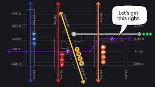
10:00 - On this map, the Subway services currently known as 1, 2, 3, 4, 5, 6, 7 (former IRT) are shown as black lines. .. ?
9:40 - In this map, is there a Hudson Tubes (PATH) train from 33 Street to Newark?
I grew up with the NYC subway map. I’m bias. So when I see other subway maps, like the Boston Metro… it kinda ticked me off how they use the same color for a different route entirely.
And the lack of detail on other map ahhh. What worst took a Cartography class so it pains me even more.
We have things similar to Jeepneys in Caracas but we call them "por puestos" they're like small buses and they also do not have concrete stops but rather a route.
and the directions are also similar lol we don't have door numbers and our "post codes" are next to useless. My bf was always very confused since he is British and post codes in the UK are quite precise.
Hey! Unrelated question: would you recommend an app or actual prepaid sim card to have a US number and use apps like Revel, Seated, etc that won't take many or most country codes? Thanks!
I only see here I need to go, & what routes. I wonder if you’ll do all bus maps. Though, I could still get around by landmarks.
Hi. Great video. Where I can get this map?
I've been in a position to assemble timetables and maps for public transportation. As long as politicians and others are involved the more items that have to be shown as someone either official or customer will complain.
A lot of non-subway information is on the subway map because in the heyday of paper maps, subway maps were used for far more than just the subway! Often you might carry one with you everywhere and no other map, and of course they were free at stations; even today, people use the subway+buses to get to MNR/LIRR stations, so their presence makes sense, they're part of the same transit system (despite separate fare structures and rules). Re your @9:25, "Sometimes I have a hard time just using my small cell phone, let alone 3 subway maps that you fold and unfold" - I THINK YOU'D BE SURPRISED! You might actually find it EASIER to unfold a single large subway map and use it for navigation and wayfinding than scrolling on a cell phone. It is, of course, a skill, and one that a lot of people have never learned in era of smartphones. But it's kind of like reading a broadsheet newspaper on the subway. I really like the NYC subway map, and disagree with you that "designers" hate the idea of using subtle cues like font serifs to distinguish neighborhoods from landmarks. One of the effective things the map does is to subdue the non-critical information in lighter colors and backgrounds so if you don't need it, it doesn't get in the way.
Whether for driving or riding the subway, actual maps (paper or on line) are useful to show a fuller context than just reading GPS directions off your phone. I like to know where I'm starting, what I'm passing through, and where I'm ending in one image. Lose your phone service, and you will be completely lost. Your historical maps were great!
That current NYC Subway map is like the Webster's dictionary, you can have abriidged or unabridged. Boston has a map similar to NYCs, except the map is spatially distorted, to allow for typing in all the light rail stops, especially. The MBTA map also has key bus lines and commuter rail stations and lines and the Silver Line BRT system. They also had a map with just the Rapid Transit and Light Rai lines, which was small to be a trifold card, smaller than a trifold wallet.
As for Manila, you must e a Filipino or really earned the language to understand where the Jeepneys are going or to use the trikes, back before smsmartphones and Google Translate.
I have heard, *so*many*times*, how the MBTA subway map has distorted people's ideas of Boston geography in horrible ways, resulting in them learning only years later how close and far away things really are. That happened to me, too, although not in the crazy way of some stories, like, people taking the T for an hour to go between places that are a 15 minute walk. There's a real cost to omission of geography!
QUESTION: Thea, I love all your videos. I was wondering, though, if you have ever done one on how streets in Manhattan are numbered. I know there's some formula that can be used to figure out what the cross-street for a particular address is, but why does there need to be a formula? Why is the Wintergarden Theatre's address 1634 Broadway when it's nowhere near 16th Av or even 160th Av? It's between 50th and 51st! Thanks to you I now have an understanding of addresses in Queens, but could you please help me with addresses on Manhattan streets. Thank you 🙂
My earliest videos are actually on the Manhattan grid.
Part 1: ruclips.net/video/Wv2L6oe9pAA/видео.html
Part 2: ruclips.net/video/4YiqZdk0c8Q/видео.html
There's not enough information on the MTA subway map. It voluntary ignores LIRR and PATH and NYC ferries.
The jeepneys you describe reminds me of the jitneys in Atlantic City. Have you heard of them?
No, I haven't. I just know of the Jitney for Montauk.
Atlantic City Jitneys are private-owned vehicles that run on Pacific Avenue (the major street parralel and closest to the beach). NJ Transit buses run on Atlantic Avenue, a block farther from the beach.
PS Loved your commentary in this one.
I feel the NYC Subway map is just not very useful. With a proper line diagram transfers and routes are much easier to find. To find start and end point you need detail maps anyways.
nice to see zurich's s bahn map in the vid
Grüezi!
I like the NYC transit map much more than cities that just show straight lines for trains. People praise the design of the London tube map, for instance, but it's useless for actually showing where the stations are in relation to other things. Showing the water, parks, and major streets helps with that. I also don't mind having the commuter lines on the map. If you're going to or from the outer boroughs, it can often be more efficient to take a commuter train than the subway, and it's good to know where the various lines are in relation to each other. The Statue of Liberty ferry probably is a bit excessive. A large part of the audience for this map is tourists, though, and showing that ferry is really not much different than showing other landmarks.
The worst part about the NYC Subway map is that all the service patterns are drawn with a single line. A line that splits into three directions on one side and 2 on the other side and also has rush hour and express service? Super hard to visualize if you don't put every service as a seperate line on the map. Maps like the KickMap are therefore much much easier to understand for someone who is looking for information on how to get somewhere and is not 100% familiar with the system (the intended user of a map in the first place). That's an issue beyond just style (having landmarks on the map). Therefore this map is one of the worst transit maps for any major city in the world because it fails at its most core purpose.
What there's a police shield symbol at Yankee stadium station. 5:36
As Jay Foreman said "Most other subway maps followed in Beck's footsteps except for the New York subway which insists on being as baffling and ugly as possible."
I laughed at your reference to the person who believes Helvetica contains the cure to cancer. I know people like that! Personally I think Comic Sans hold he cure to cancer but most people diss it because it is so frivolous. You know that thing about first impressions. Have a good day!
Where can I find the discord community?
just checked on mine! theres a label just saying "tramway" on the line
its from feb. 2020 by the way
Also there are new beta maps testing all over the system like on the 42ND St Shuttle and at Fulton Center
Almost 5 minute of intro in a 15min video? It's too long IMO. Regarding the map, I think commuter rails or conventional railways and other public transit info should be on it since it's a map that is supposed to help people connect. Like what's said in the video, they are in muted colors so the focus is still the subway system. Official Tokyo Metro Subway map also shows JR lines and other private rail lines, for instance.
Thank you for your presentation. Manila is fascinating. There are pros and cons to any mapping scheme, and while I appreciate your point of view, I want to expose you to someone else who also does great design. The New York City map is "busy" but it is great design - the minimalist design typified by Jony Ive's work at Apple doesn't work well for everything. Knowing the coverage of the commuter rails is important not just to "some people," but to a lot of people, and not just to tourists - to business people too. I recommend you read Edward Tufte's books: THE VISUAL DISPLAY OF QUANTITATIVE INFORMATION and ENVISIONING INFORMATION would be useful to showing you why busy maps can be very valuable. I will also post here Joseph Brennan's integrated transit map, which includes New Jersey. The New York City subway map is not merely the result of a few people's purely parochial interests, or because someone watched a movie. It is a product of consensus about the most useful way to present transit information. That consensus can change of course. I offer you my encouragement.
The subway map is not easy to use. It requires some studying to figure out what is going on and how it works. Once you understand it, you don't need it anymore. Either you'll memorize your commute or common places or your will use the apps to get you to new destinations.
Station navigation, that's a different story.
In November 2022; Me And My Asian Wife (Maya-Minnie-Chu) Went To New York City For Our Honeymoon.
Subway MAP.
You see what i did there? It's a map, with the subway the lines. Not some designer garbage.
Why are the commuter trains on there? So people who ride them or may ride them know where they are in relation to the subway. So people can figure which subway they can take and then walk to the commuter station.
They are also clearly labeled different and more done so in such a way if you're not looking for them you won't even notice them.
Not everyone takes a subway that has a direct connection to the commuter trains. And some don't have the option at all. Harlem line for example.
Let's "design" some stupid "map" that isn't even actually a map that actually sucks as a map but looks "pretty" and simple and something a graphic designer would celebrate!
So what are you talking about a completely different country, when the title says about new york?????
Good video, but you could really start at 3:49
Why would you want LESS information on your map? As long as it doesn't hide the main point of the map (it doesn't), the more info the better.
Sometimes, less is more. Especially when it's about information that isn't absolutely necessary for the map to have.
I prefer the geographical map. And maps that include the metro AND the trains, so I can plan a route with the two in mind.
That being said, the geographical map just needs to fix the inconsistencies that you mentioned.
For example, if the touristic ferris are included, why not included its stops. Or why not include the commuter ferris.
And the different train operators should be indicated with a different color.
Etc, etc
I hate the nyc Subway design of now. The 1980s -1990s map was god tier
And it seems the map has changed again… TODAY. I’m seeing a few reports on insta about it
👏🏼👏🏼👏🏼👏🏼👏🏼👍🙂🥰🥰i am going to Manila next week. 🙂
Hope you enjoy it! Make sure to go to the beach.
878 big thumbs up! 😎👍
Idk, it looks good to me
I much prefer the cleaner style for subway maps, similar to London's and São Paulo's maps for their train systems, even if it means that distances are skewed.