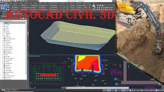
Civil 3D Surface Creation

HTML-код
- Опубликовано: 8 сен 2024
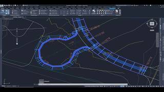
- In this video, we'll explore the fascinating process of Surface Creation using Autodesk Civil 3D, the industry-leading software for civil engineering and design.
Creating accurate and detailed surfaces is crucial for any civil engineering project, and with Autodesk @Civil 3D, you have the power to do it efficiently and effectively.
In this comprehensive tutorial, we'll walk you through the step-by-step process of creating surfaces from survey data, point clouds, and other essential sources. Learn how to manipulate and analyze the data to generate precise 3D models of the terrain, enabling you to make informed design decisions and deliver top-notch projects.
Whether you're a civil engineering professional, a student, or someone looking to enhance their skillset, this tutorial is tailored to suit your needs and help you become proficient in surface creation using Autodesk Civil 3D 2024.
Subscribe to our channel for more Autodesk Civil 3D tutorials and stay updated with the latest tips and tricks to improve your civil engineering workflows. Don't forget to hit the notification bell to never miss an upload!


Amazing breakthrough btw
Great insight!
Thank you very much!!!!! You are the best!!!
Nice video... Greetings from NZ.
Thanks for watching!
Great Video, Thank you
Well Explained. Thanks for the in depth knowledge..
Very clearly explained, iam kind of behind on how you added the points, did you add them separately or just one file like points,edge, top...? Iam just using one file so dint manage to align the edge
your presenttation helps me a lot, if you allo me, can you give your data you used for your presentation, i want to study and learn further about the surface creation based on your data and video. thanks,
Can you shear your points data?
Can Civil 3d 2023 work with tutorials?
yes!
How do we know, what points should be used for breaklines????? Please
Typically, you would connects points for areas like: top of curb, flow line, lip of gutter, edge of pavement, back of sidewalk, center line of road, etc.
Hi, are the point groups manually added by the user or are they obtained during field survey
The point data comes from a survey in the form of a text file. You can import points from the text file into Civil 3D. See our video on C3D Points: ruclips.net/video/RStSVRvMaFI/видео.htmlsi=E7lQdcV8LIEYsOUo
Typically existing ground points are collected by a survey team and given to the CAD team in the form of a .txt file or .csv file. See our video on importing points.
Assalamo Alaikum .
I want to have online Training In Civil 3D.
If possible please let me know?
absolutely! We offer 9 different Civil 3D training classes from beginner to advanced levels. You can view the dates and class details here: cadmasters.com/civil-infrastructure-design-training/
can you provide the pdf of point data