As a note for QGIS-LTR 3.16 for macOS, when saving the layer file you go to the toolbar at the top of your screen and click ‘Layer’ then click ‘Save As’
Thanks for video One have one query;If we have large dem eg Krishna watershed how can we check the utm projection of our whole location? Would it falls on same projection.
3:08... Does your argument right? X is longitude and Y is Latitude.... Cz commonly, its reverse... X is latitude (north and south), Y is longitude (west and east). Could you tell me about your argument?
I AM HAVING THE SAME TROUBLE AS OTHERS. MY CONVERTED FILE HAS NOT APPENDED X,Y COLUMN ONLY THE ORIGINAL DATA. I SELECTED LAT LONG AS YOU SPECIFIED. PLEASE LET ME KNOW IF YOU CAN HELP.
quiet informative, however l have got geodetic trying to convert it to ordnance survey for Britain, the UTM 46N is not available, can anyone help to convert it
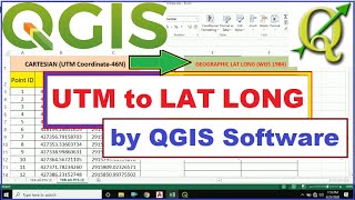
followed the above step-by-step procedure but the result (northing, easting) did not appear after opening the output . I have a geographic data (lat, long) from google earth and I need to convert ( northing, easting)location is at south africa longitude is 30.68407
I followed the above step-by-step procedure but the result (northing, easting) did not appear after opening the output . I have a geographic data (lat, long) from google earth and I need to convert it to prs92 zone 3( northing, easting)
Hi Sir, In my lat long data when I give it in online lat long to utm converter the UTM ZONE is showing as 43R. MAy I know which UTM zone should I take in QGIS while converting?? please reply
I would make a copy of your CSV sheet, then in the new sheet use the above process to make XY in UTM format from your original Lat/long (keep the corresponding Z in another column), then, later paste the Z into the corresponding new XY UTM CSV file, that will work.
dear thanks for your video. i tried a lot but my converted csv file is not showing any value its not giving me back the WSG 46N values. Please help me to convert it into BTM also. 23.19153611 N 90.42219444 E.


Make sure you select Geometry: As_XY.. This is not emphasized in the video.
Pls find another video in our CHANNEL where We have shown with XYZ plane
Thanks, it's very important detail.
You are the best !!! :)
hi. How do i do the opposite? I have XY date. I need to convert to Long and lat
Thanks for this comment!
Thank you very much!!! At first I was so frustrated because i thought i'd have to transform each coordinate manually but you saved me!
You are most welcome!
As a note for QGIS-LTR 3.16 for macOS, when saving the layer file you go to the toolbar at the top of your screen and click ‘Layer’ then click ‘Save As’
Great video and explanation, this is still relevant in 2021 - Cheers
Glad it was helpful!
Thanks for video One have one query;If we have large dem eg Krishna watershed how can we check the utm projection of our whole location? Would it falls on same projection.
I think zone will be same. Zone changes in every 6° of longitude.
Amazing! This was so helpful - Thank you.
3:08... Does your argument right? X is longitude and Y is Latitude.... Cz commonly, its reverse... X is latitude (north and south), Y is longitude (west and east). Could you tell me about your argument?
Yes my argument is right.bcz Y means The value along Vertical axix and X means the value along Horz axis. And vertical values are called LATITUDE.
I AM HAVING THE SAME TROUBLE AS OTHERS. MY CONVERTED FILE HAS NOT APPENDED X,Y COLUMN ONLY THE ORIGINAL DATA. I SELECTED LAT LONG AS YOU SPECIFIED. PLEASE LET ME KNOW IF YOU CAN HELP.
same here. If you have found any solution please help...
While exporting please select X Y option in the exporting dialouge box.
quiet informative, however l have got geodetic trying to convert it to ordnance survey for Britain, the UTM 46N is not available, can anyone help to convert it
Excellent explanation, Thank you Sir
+Chamara Prasanna
Thank YOU for your support 😊
Hey, the software notify me that the field added is always existed , what can i do???
followed the above step-by-step procedure but the result (northing, easting) did not appear after opening the output . I have a geographic data (lat, long) from google earth and I need to convert ( northing, easting)location is at south africa longitude is 30.68407
Do it properly...and make sure have choosen X Y while exporting... otherwise give me the lat long data i will try
Hello please can help me . how to convert UTM to LGM am from Mauritius thanks
I followed the above step-by-step procedure but the result (northing, easting) did not appear after opening the output . I have a geographic data (lat, long) from google earth and I need to convert it to prs92 zone 3( northing, easting)
Select PRS92/Philippines zone 3 ESPG:3123 While selecting the CRS.
Make sure you entered right lat long coordinates
Sir what is calculation formula manual from utm to 2 d lat and dep
Hi Sir,
In my lat long data when I give it in online lat long to utm converter the UTM ZONE is showing as 43R.
MAy I know which UTM zone should I take in QGIS while converting?? please reply
What is the longitude value?
Apply simple formula to find the utm zone.
Utm zone= long/6 + 31
How to find utm zone. I uploaded a video on this channel. U can find it.
Well done job.
Very nice sir
Thank you
Please help me. I also enter my coordinates in WGS 84 Lat Long but don't find the updated UTM in WGS 84 Cartesian coordinate. The file is empty.
Make sure that u r using appreciate UTM Zone.
Calculate UTM Zone first from LATITUDE LONGITUDE values
Thank you but what is we have utm and need to invert to wgs84
Video uploaded
@@LearnExplore you mean sam we can do
But I tray it not invert only sam output utm
nice video
Sir. Stage measurement complet. then how to use auto cad calculation and stage 3d pictures
Pls upload video
Pls
Hi Thank you can you convert ED 1950 Iraq National Grid to UTM
It may be possible by QGIS
thanks
how can i convert (LCC)Lambert conformal conic coordinate to UTM/WGS84?
thank u
Most welcome
Hello Why does my XY has same Value as Lat Long and why does it fail to convert>
thank you very much, you helped me to solve an issue
DEAR SIR IN WHICH TUTORIAL YOU CONVERT MANUALLY DMS TO LAT &LONG PLEASE SEND LINK
Degree Minute Second to Decimal
Link : ruclips.net/video/-BOj-hJynBc/видео.html
good job
fantastic
nic
How we convert UTM Coordinates to Local ?
will make a video on this topic.
Kindly let us know
How to add elevation?
ruclips.net/video/hnaKsVkJQLc/видео.html
watch this video I have made just for your query.
I would make a copy of your CSV sheet, then in the new sheet use the above process to make XY in UTM format from your original Lat/long (keep the corresponding Z in another column), then, later paste the Z into the corresponding new XY UTM CSV file, that will work.
Great idea!👍
@@LearnExplore Thanks for the tutorial.
its not working .it cant run
What's the problem. Plz share
it replies that I have no permission
I can barely understand you at all. The audio is extremely muffled - mouth way to close to mic, and it is quite distorted.
Actually that time i was new to youtube and was nervous.
I'm extremely sorry for this. Please use subtitle.
dear thanks for your video. i tried a lot but my converted csv file is not showing any value its not giving me back the WSG 46N values. Please help me to convert it into BTM also. 23.19153611 N 90.42219444 E.
Ur data lies on UTM 46N
Pls follow the steps in the video carefully.
Make sure that when u r exporting data then change the CES to UTM 46N.
Terjemahkan ke bahasa indonesia
Doesn't work!
Should Working well... Please do the process again
@@LearnExplore Sorry, it works as long as you change geometry to AS_XY!
unit of easting northing? is it possible to convert in meters if not?
Hi Thank you can you convert ED 1950 Iraq National Grid to UTM
Terjemahkan ke bahasa indonesia