I live near this mountain and this video was so good that I genuinely went on an impulse trailrun out and back along this 2-shaped ridge today. Had a lot to think about the whole time. I even saw a bear, about at the top of the arch of the 2.
Man, I'm always impressed by the sketches. Like a bob ross painting the way it comes together in just a few strokes. I assume you have a strong mental idea of how to draw certain common shapes/folds, and that it just came together over years of study and familiarity, but it impresses me every time how well it works.
I live in Craig County and have wondered about that section of mountain. Until you pointed them out in another video I never realized how huge the landslides on sinking creek mountain are. Very obvious at 1:30
Wow! So very cool. That sandstone is very hard, too. When Mountain Valley Pipeline bored a tunnel about 60 feet deep under Peters Mountain in Giles County in 2023-24, they had a really tough time. The Silurian sandstone repeatedly broke their drill bits, and when they encountered shale it tended to gum up the whole drill rig. Took them much longer than they expected and am sure it was much more expensive than they anticipated. The mountain has its ways.
Awesome. I hope you cover Burke's Garden and the Roaring Plains/Dolly Sods plateau one day. I've been wondering when someone would do an Appalachian focused geology channel. This is an awesome because I have always wondered about standout structures of Appalachian geology. These videos help a lot.
I love how in all these videos, the geology driving the structure is like 100x bigger than the structure itself. Something satisfying about that. This gargantuan fold in the crust of the earth makes this little tiny ridge on the surface. And that tiny ridge is a mountain.
Right on! I have a good time with it. I walked up and down the 2 so many times I had to do something with it. Actually has a big bear population up off the top of the 2. Always pushing up the little creeks and ravines til someone has to decide who is going up the steep hill and into the next holler. I was always having to divert around them in fall 2017 and 2018.
@@TheGeoModels : Did you ever do anything west of there, near Kelly Knob? If so, you would have likely traipsed over the farm where I grew up, or nearly so.
Man I love your videos. Road cyclist here, and I literally search the Appalachian’s on google maps almost everyday to find the best mountain roads to climb. Taller the better.
@@markgallagher5908 Likewise. Amazing that the Adirondacks are being pushed up by a hotspot. I wonder if there will be an explosive eruption, as happens above the Yellowstone hotspot.
I have been looking at Burke's garden, not to far from the 2, and trying to figure out how the heck that formed. I think this video helped it click in my head. I believe these coordinates (40°11'16.9"N 78°18'24.9"W) show a Burke's garden in the making. The stone surrounding Burke's garden is likely this hard sandstone and the rock exposed in the valley was the softer stone that was eroded out via the one river that broke through the harder rock. As the rivers carve up the valley and send it out along the river, it hollows out a valley like Burke's garden.
@TheGeomodels: Philip, love your explanatory skills, and it's all the better that I live in the Southeast near a lot of the features you cover. It seems most geology channels want to focus on the Rockies and thus overlook the fascinating (and much older) geology we have here. One question for you, though... there's a valley cutting a tremendous, incredibly broad, perfectly circular (300mi diameter!!) arc across Mississippi and Alabama, centered roughly on the Talladega National Forest. You think you could tell us in a vid what THAT thing is about?
Oh goodness yes. I rode past it many times as a kid, since I grew up in Virginia (just a bit west of the 2) and my grandparents were in North Carolina. Also what makes the steep descent down the mountains northwest of there, on I-77 or Rt. 52 might be interesting to include, since that's a pretty remarkable grade -- with a fair bit of historic significance for the area, since it makes quite a wide wall that they couldn't get a railroad up or down.
another banger. i shared your channel with a geologist friend of mine and it turned out he mapped the sequatchie valley fault line from your earlier vid when he was in grad school, small world
Some of the best Paint drawings on RUclips, by far. Although the first few times he talked about something "in Paint" I almost thought he was talking about the town of Paint Bank, ten miles north of here. :)
Another fine video! I've but once traversed the Sinking Creek Valley on 621, cut through Millers Cove on 620, and out to 311 at Catawba Grocery. Spectacular area from the ground, way mo' bettah from the sky via LIDAR! It would be grand to see a GeoModels treatment of El Solitario, a breached laccolith in far West Texas in and adjacent to Big Bend Ranch State Park. If I'm not mistaken, it's the furthest S-SW surface exposure of the Appalachian-Ouachita-Marathon fold belt so it'd be but an extension of your terrific work in the Appalachians. El Solitario looks like and was mistaken for an impact structure back in the day, but it's actually a very strangely circular decapitated laccolith with some extruded volcanic breccia in its center. And it's HUGE--many km in diameter.
It's a cool spot. Very distinct from Valley and Ridge topo much further south or north. Got the right combo of sandstones in the right place and a specific fold/thrust style
Could you please do a video on the geology of the Monongahela National Forest area or New River Gorge region? I love your Appalachia videos! There is so much interesting geology going on. I would love to see an in depth look at the more iconic WV destinations.
Might have something from down around Snowy Mountain Road and Monterey VA one of these days. Cool old oil and gas story down there. Elkins Valley and Shavers Fork up on the Plateau is another good one. If I had more time I'd make more!
Never seen your videos before. I live a couple hundred miles away from this mountain. I travel all over the region for work every day. I've actually been to the valley just south of that but didn't know or notice the 2 on the map before. When I saw your thumbnail I instantly recognized the mountains as being in Virginia because of the characteristics, then I noticed the name Catawba and instantly knew where this is. I went to Google maps and zoomed right to it before even watching this video! Anyway, I thought that was a cool little experience 😂. Gonna watch the video now
Hey! I work for the Appalachian Trail specifically in Catawba Valley. I'd love to talk to you more about the geology of the area and get a lot of the geo map you mentioned. Thanks for the great info, I'll share it with visitors!
Would this be considered a monocline? I just found the channel and I appreciate being able to see what's happening on the east coast. Keep up the great work!
Keep the Appalachia coming, seems like it’s hard to find much on RUclips about app geology, your recent video on the ancient Teays especially was great, if someone really wants to appreciate how wide the valley was/is travel SR 32 outside of Jackson Ohio going east
Hey I love this channel, I did my bachelor's degree in EVS and it reminds me of a lot of what I loved about it. But I gotta know, WHERE is your accent from. I've never heard another southerner pronounce their "O"s like you and it's fascinating
Great video man. It would be near impossible for me to get enough time off work to do a through hike of the AT. Hopefully by the time I retire I’ll be in good enough shape to try. I could always do sections though, but either way this is a feature I will definitely be looking out for when I make the trip.
yes the AT , awesome place, through hiked 85,89,97 didn't even realize the 2 shape in 85 till i saw on a good map. pretty cool . hiked at in sections in 80's with a geologist , been into it since , hiking you miss some cool stuff , always worth going back
Hey, I've really enjoyed watching your videos! I'm from the Central Pennsylvania region of the Appalachian mountains and I've always wondered about the Susquehanna river, how it cuts through the mountain ridges north of Harrisburg. I've heard that the Susquehanna river is one of the oldest rivers in the world and it actually predates the mountains themselves. When I look at how the river cuts through, it just doesn't make sense to me... Would it be at all possible to do a video on this particular region some day?
Yeah, I'm planning one on the Valley and Ridge patterns in PA for sure. To some extent it will talk about why the Susq goes where it does. It actually doesn't pre-date the mountains, though it does appear to by cutting right through. It's a pretty good story. I'll try to prep it up within the next few weeks!
Just found this channel and love it. Could you do a video on the giant crescent shape we see stretching from about Corinth Mississippi and through Prattville, Alabama? Is that an ancient shoreline?
Looks like a five to me if you add in the the mountains exposed above what is typically in writing to the start of the two. Looks like a five with a line under it.
I have such a problem with relief and shadows. My default perception is that the sun is in the top-right corner, so I see everything as a depression. That 2 looks like its been struck into the land with a massive typewriter. Happens with lunar and planetary images as well. By default I see domes instead of craters. I can force a switch-back by repositioning the direction of the light source in my head and I'll be good for a while, but then it can switch back. Never been sure if this is a unique problem I have that says something deeper about the way I perceive things, or if it happens to lots of other people.. Oh - love these videos!!!!!
Glad you like them! The inversion is tough for me with sinkholes and craters, for sure. I had to review some lidar from Mars and had the hardest time avoiding inversion. I think the overall different topographic grain caused it. I go for the perspective/horizon views whenever I can to try to get around it.
My father in law moved to the Knoxville area for a time and the big mountain they all see in the distance is Mt Leconte, it has three peaks, he called it "triple nipple mountain."
Love your content! Could you do a video about the Sierra Madre Oriental "Bend" Around Monterrey, Mexico and Saltillo? I've always been curious about how they formed and their famous cliffs and dramatic rock walls. Thanks!!
Oh neat, I flew over that area a few years ago but doesn't look like I got any pictures of the 2 (plenty of the ripples though, it's a real cool feature), but now I have a reason to fly back over there
Really enjoy your videos. There is another group of mountains that seem to be unusual against the normal background in the Appalachians. This is NW of Knoxville and includes Pilot Mountain and Frozen Head State Park. Would love to hear your interpretation.
They will probly show up soon enough...trying to do a Pine Mountain and Cumberland Gap sort of thing. It will make all the way down to Jacksboro and the Brushys
I absolutley love these videos. Your super talented, and the level of detail and information is top notch. Born and raised on Savage mt, right up the road from the gateway to the alleghanys. So naturally id have to ask. Waffle rock. Whats up with it? Jennings randolf lake, is that the only place that formation has been found or is there other instances around the world?
I see a 5 as well as the ”2”, the bottom half of which belongs to the “2”, with the “hat” of the “5” above it. Sort of a superimposed “25” or “52”. Actually with that top bar on it, it perhaps most looks like the Tibetan letter ཏ (ta). Or the Coptic Ⲝ (ksi) or Cyrillic Ђ (dje). Whoever called it the “Dragon’s Tooth” would surely have called it the “Dragon’s Two” had they named it during the era of Google Earth. 13:25 my education and degree is actually in architecture, even though earth science is my primary avocation and interest is earth science and my day-to-day vocation is building and designing web-based software, and my training in architecture definitely has a lot of parallels to structural geology. The kind of spatial reasoning you need to work to develop in order to conceive of and depict complex spaces and structures in 2D and 3D (and sometimes 4D) has many parallels to the kind needed to do structural geology work. Not to mention being able to draw and do 3D modeling helps immensely in both architecture and in structural geology.
So, to me the real mystery is: How is it possible that I, despite having grown up only about 15 miles due west of that mountain and been looking at maps of the area for nearly 50 years, have never noticed that it looked like a "2"? (Edit: Oh, I should have watched the rest of the video first; you answer that pretty clearly. Also I think our vacuformed blister map may have been one section to the west of the one that had this mountain on it.) You're right. I'm never going to unsee it. Though it's a shame you usually can't quite see it from the planes flying into Roanoke airport.
Hmm, I'd be more apt to look up a bit and see the numeral 5 riding over that 2. The 5's head line flowing towards Abbott, rather than the 2's foot going towards Catawba.
My uncle lives right beside this, like on Craig valley rd very close to the dragons tooth trail head parking. I am going here next time I am down there
Yes, lidar can show that. It depends on how old it is, but you can absolutely see subtle landslides that might get worse with prolonged rain or construction. I use it almost every day for work for that exact purpose.
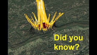
The back edge of the 2 would have connected to the layer coming up off of Catawba Mountain to the southeast. Not a huge amount of the once-connected layer has been lost to erosion there. The front of the 2, however, was broken off many, many miles to the southeast, from a layer that is now buried under miles of thrust sheets. No one knows exactly where the break-off point (the "ramp") for the front of the 2 would be, but it's a good ways away. If you want to poke around at the geography in the area, the sandstone layer forming Catawba Mountain around McAfee Knob goes down under the ground and pops back out around Hanging Rock, near Salem. Another interesting one is Brush Mountain, just west of Blacksburg. The sandstone layer that forms Brush Mountain goes down under the ground right around Toms Creek and then pops back up at Price Mountain in Christiansburg. The coal mined around Merrimac is the same general coal formation that got mined on Brush Mountain. It's down under a couple of thousand feet of dolomite between the two mountains. They tried to drill coal bed methane out of it, but it appears it was not economically viable.
@@TheGeoModels well you casually dismiss the mathematically perfect elliptical geometry of the Carolina Bays, so please provide the citation for the peer-reviewed paper showing how wind and water can create this geometry, thanks. since we can actually analyze the geometry, you have to start with the geometry and work backwards from there. we KNOW these were created from impacts due to the elliptical geometry (see Plato and Messier Craters). Zamora's theory starts with the geometry which implies an impact, then the mystery is figuring out how these impacts were able to occur. just because the theory isn't complete or perfect now doesn't mean you should ignore the mathematically perfect geometry that is the basis for the theory. that's not very scientific of you, especially when you espouse a non-peer reviewed theory for their creation.
How does the folded structure get turned up on the one end to actually make the 2? That would seem to involve forces perpendicular to the main thrust and fold. Nothing of it seems to show cross-sectionally.
the lifted end is resting on a thrust ramp that the lower end is not. it would take several drawings…I guess the shortest answer is that the lifted end slid up onto shallower layers than the end that is still buried and out of sight.
The underlined 5 I see now that you mention it. The 5 that appeared more prominent to me though was a couple ridges to the West sitting between Captain and Huffman.
im going to be honest i thought you where going to point out the mountain shape in a 5 ... and was like oh you decided to look at the #2 instead alright then ...
I have been looking at that too. I posted this as a comment then saw your comment so I thought I would leave this here too. This is what my gut is telling me is happening there. I have been looking at Burke's garden, not to far from the 2, and trying to figure out how the heck that formed. I think this video helped it click in my head. I believe these coordinates (40°11'16.9"N 78°18'24.9"W) show a Burke's garden in the making. The stone surrounding Burke's garden is likely this hard sandstone and the rock exposed in the valley was the softer stone that was eroded out via the one river that broke through the harder rock. As the rivers carve up the valley and send it out along the river, it hollows out a valley like Burke's garden.
Strange how it's known as the tooth of the dragon and it's a two or twooth of the dragon. Very coincidence dental, but I don't believe in coincidence but coinci dental, is probably a dragon's dentist! Lol
You must attended Mudfossil University here on RUclips. Roger Spurr has explained exactly what the “natural landscape” truly is. I have been taking his 15 minute challenge for the last 2 1/2 years and anyone who curiously investigates his true claims, can’t miss it…


I live near this mountain and this video was so good that I genuinely went on an impulse trailrun out and back along this 2-shaped ridge today. Had a lot to think about the whole time. I even saw a bear, about at the top of the arch of the 2.
To me, it seems there is a #5 in there, as well,
Used to give the bears right-of-way all the time down in the little valley to the north of the 2. It got really bad one warm fall.
@@charlesyoung7436 Oh yes, I see the 5 now!
Man, I'm always impressed by the sketches. Like a bob ross painting the way it comes together in just a few strokes.
I assume you have a strong mental idea of how to draw certain common shapes/folds, and that it just came together over years of study and familiarity, but it impresses me every time how well it works.
also lots of practice helps when sketching anything!
(ppl who can sketch & draw impress me too)
I live in Craig County and have wondered about that section of mountain.
Until you pointed them out in another video I never realized how huge the landslides on sinking creek mountain are. Very obvious at 1:30
Biggest east of the Mississippi, by a longshot. Definitely "world class" features for sure
Wow! So very cool. That sandstone is very hard, too. When Mountain Valley Pipeline bored a tunnel about 60 feet deep under Peters Mountain in Giles County in 2023-24, they had a really tough time. The Silurian sandstone repeatedly broke their drill bits, and when they encountered shale it tended to gum up the whole drill rig. Took them much longer than they expected and am sure it was much more expensive than they anticipated. The mountain has its ways.
Awesome. I hope you cover Burke's Garden and the Roaring Plains/Dolly Sods plateau one day. I've been wondering when someone would do an Appalachian focused geology channel. This is an awesome because I have always wondered about standout structures of Appalachian geology. These videos help a lot.
I love how in all these videos, the geology driving the structure is like 100x bigger than the structure itself. Something satisfying about that.
This gargantuan fold in the crust of the earth makes this little tiny ridge on the surface. And that tiny ridge is a mountain.
This channel is so cool. Thanks for sharing all your knowledge and sick paint skillz
Right on! I have a good time with it. I walked up and down the 2 so many times I had to do something with it. Actually has a big bear population up off the top of the 2. Always pushing up the little creeks and ravines til someone has to decide who is going up the steep hill and into the next holler. I was always having to divert around them in fall 2017 and 2018.
@@TheGeoModels : Did you ever do anything west of there, near Kelly Knob? If so, you would have likely traipsed over the farm where I grew up, or nearly so.
Oh, another Philip Prince video. Grabbing a beer and a snack then laying into this.
Hahaha!!! It’s really a great channel!!! I enjoy it as much as you. Have a great night.
Thank you good people! Might try to get a 2nd one this week
@@TheGeoModels Don't kill yourself making it happen. I am patient and still have a bunch of your older vids to work through :)
Funny when you read a comment and realize that you're doing that very thing
Man I love your videos. Road cyclist here, and I literally search the Appalachian’s on google maps almost everyday to find the best mountain roads to climb. Taller the better.
Am enjoying this channel and Myron Cook’s.
Awesome!
Nick Zentner also has a great channel.
@@markgallagher5908 Thanks. I watched and enjoyed his video about how The Rockies formed, but you prompted me to subscribe to his channel.
@@joshadams8761 Geology is one of those fascinating subjects that I can't get enough of.
@@markgallagher5908 Likewise. Amazing that the Adirondacks are being pushed up by a hotspot. I wonder if there will be an explosive eruption, as happens above the Yellowstone hotspot.
I never cease to be amazed at geologic time scales and the changes that can occur over them.
I have been looking at Burke's garden, not to far from the 2, and trying to figure out how the heck that formed. I think this video helped it click in my head. I believe these coordinates (40°11'16.9"N 78°18'24.9"W) show a Burke's garden in the making. The stone surrounding Burke's garden is likely this hard sandstone and the rock exposed in the valley was the softer stone that was eroded out via the one river that broke through the harder rock. As the rivers carve up the valley and send it out along the river, it hollows out a valley like Burke's garden.
This is really a cool feature!
I live in neighboring Smyth County and I have never made it over to Burke's Garden.
Ah, "God's Thumbprint." The winding road to the east is a fun drive. Have never done the fire trail to the north, though,
Lovin the videos, man. Seeing interesting and unique features of our area is refreshing. Thank you.
Glad you like them!
I just came across your channel. I live in the Smokies and am delighted with your woirk. Thank you so much.
@TheGeomodels: Philip, love your explanatory skills, and it's all the better that I live in the Southeast near a lot of the features you cover. It seems most geology channels want to focus on the Rockies and thus overlook the fascinating (and much older) geology we have here. One question for you, though... there's a valley cutting a tremendous, incredibly broad, perfectly circular (300mi diameter!!) arc across Mississippi and Alabama, centered roughly on the Talladega National Forest. You think you could tell us in a vid what THAT thing is about?
You should do a video on pilot mountain in NC. Been living near it all my life and it’s probably the most unique looking mountain I seen
Oh goodness yes. I rode past it many times as a kid, since I grew up in Virginia (just a bit west of the 2) and my grandparents were in North Carolina. Also what makes the steep descent down the mountains northwest of there, on I-77 or Rt. 52 might be interesting to include, since that's a pretty remarkable grade -- with a fair bit of historic significance for the area, since it makes quite a wide wall that they couldn't get a railroad up or down.
Came here to comment this exact thing. Looked on RUclips and there are no good videos about it yet
another banger. i shared your channel with a geologist friend of mine and it turned out he mapped the sequatchie valley fault line from your earlier vid when he was in grad school, small world
I've hiked Dragon's Tooth a few times, but never realized the '2' feature until now, cool and thanks!
You are like the Appalachian Nick Zentner! Great illustrations and great narrative explanations.
Funny I first saw a 5. Top sweep of the two is the bottom sweep of the five. Look at the very first frames of the map before he superimposes the 2
Great job as always, thank you brother.
respect!
Another great video. I love your drawings. Still looking forward to the Tennessee gorge video.
find myself in Chattanooga right now...ought to do one. Hope to find time!
Some of the best Paint drawings on RUclips, by far.
Although the first few times he talked about something "in Paint" I almost thought he was talking about the town of Paint Bank, ten miles north of here. :)
@@TheGeoModels It's a sign! Can't deny that
Another fine video! I've but once traversed the Sinking Creek Valley on 621, cut through Millers Cove on 620, and out to 311 at Catawba Grocery. Spectacular area from the ground, way mo' bettah from the sky via LIDAR!
It would be grand to see a GeoModels treatment of El Solitario, a breached laccolith in far West Texas in and adjacent to Big Bend Ranch State Park. If I'm not mistaken, it's the furthest S-SW surface exposure of the Appalachian-Ouachita-Marathon fold belt so it'd be but an extension of your terrific work in the Appalachians. El Solitario looks like and was mistaken for an impact structure back in the day, but it's actually a very strangely circular decapitated laccolith with some extruded volcanic breccia in its center. And it's HUGE--many km in diameter.
Roanoke! I drove down there from New England and wow those valleys and ridges.
It's a cool spot. Very distinct from Valley and Ridge topo much further south or north. Got the right combo of sandstones in the right place and a specific fold/thrust style
Could you please do a video on the geology of the Monongahela National Forest area or New River Gorge region? I love your Appalachia videos! There is so much interesting geology going on. I would love to see an in depth look at the more iconic WV destinations.
Might have something from down around Snowy Mountain Road and Monterey VA one of these days. Cool old oil and gas story down there. Elkins Valley and Shavers Fork up on the Plateau is another good one. If I had more time I'd make more!
Fascinating
Never seen your videos before. I live a couple hundred miles away from this mountain. I travel all over the region for work every day. I've actually been to the valley just south of that but didn't know or notice the 2 on the map before. When I saw your thumbnail I instantly recognized the mountains as being in Virginia because of the characteristics, then I noticed the name Catawba and instantly knew where this is. I went to Google maps and zoomed right to it before even watching this video! Anyway, I thought that was a cool little experience 😂. Gonna watch the video now
Hey! I work for the Appalachian Trail specifically in Catawba Valley. I'd love to talk to you more about the geology of the area and get a lot of the geo map you mentioned. Thanks for the great info, I'll share it with visitors!
there’s an email address if you scroll down at this link. holler at me!
princegeology.com/about-philip-prince/
Just was there a couple weeks ago. Love dragons tooth. Keep up the fantastic work!
Would this be considered a monocline? I just found the channel and I appreciate being able to see what's happening on the east coast. Keep up the great work!
Keep the Appalachia coming, seems like it’s hard to find much on RUclips about app geology, your recent video on the ancient Teays especially was great, if someone really wants to appreciate how wide the valley was/is travel SR 32 outside of Jackson Ohio going east
Hey I love this channel, I did my bachelor's degree in EVS and it reminds me of a lot of what I loved about it.
But I gotta know, WHERE is your accent from. I've never heard another southerner pronounce their "O"s like you and it's fascinating
"Folding it, rising it, and chopping the top off" describes a surprising amount of Appalachian geology 🤣
truth
The Appalachian trail indicates a 2 since the number 1 is in Canada.
Great video man. It would be near impossible for me to get enough time off work to do a through hike of the AT. Hopefully by the time I retire I’ll be in good enough shape to try. I could always do sections though, but either way this is a feature I will definitely be looking out for when I make the trip.
TheGeoModels, great content you deserve more subscribers
Bless you friend...send some people this way! I will try to entertain them.
The RUclips algorithm randomly recommended this to me this afternoon, so that's a good sign for more people discovering it!
Structural Geology sounds like fun!
It ain't bad
yes the AT , awesome place, through hiked 85,89,97 didn't even realize the 2 shape in 85 till i saw on a good map. pretty cool . hiked at in sections in 80's with a geologist , been into it since , hiking you miss some cool stuff , always worth going back
Hey, I've really enjoyed watching your videos! I'm from the Central Pennsylvania region of the Appalachian mountains and I've always wondered about the Susquehanna river, how it cuts through the mountain ridges north of Harrisburg. I've heard that the Susquehanna river is one of the oldest rivers in the world and it actually predates the mountains themselves. When I look at how the river cuts through, it just doesn't make sense to me... Would it be at all possible to do a video on this particular region some day?
Yeah, I'm planning one on the Valley and Ridge patterns in PA for sure. To some extent it will talk about why the Susq goes where it does. It actually doesn't pre-date the mountains, though it does appear to by cutting right through. It's a pretty good story. I'll try to prep it up within the next few weeks!
Just found this channel and love it. Could you do a video on the giant crescent shape we see stretching from about Corinth Mississippi and through Prattville, Alabama? Is that an ancient shoreline?
Legendary MS Paint skills 👑 Can't wait to get my mind blown again in the next one.
much love
Nice work. Imagine what this landscape would look like if this was an arid environment.
Definitely not like a 2! I must admit having only one or two skinny topography-forming intervals makes the most elegant landscape.
Looks like a five to me if you add in the the mountains exposed above what is typically in writing to the start of the two. Looks like a five with a line under it.
I have such a problem with relief and shadows. My default perception is that the sun is in the top-right corner, so I see everything as a depression.
That 2 looks like its been struck into the land with a massive typewriter.
Happens with lunar and planetary images as well. By default I see domes instead of craters.
I can force a switch-back by repositioning the direction of the light source in my head and I'll be good for a while, but then it can switch back.
Never been sure if this is a unique problem I have that says something deeper about the way I perceive things, or if it happens to lots of other people..
Oh - love these videos!!!!!
Glad you like them! The inversion is tough for me with sinkholes and craters, for sure. I had to review some lidar from Mars and had the hardest time avoiding inversion. I think the overall different topographic grain caused it. I go for the perspective/horizon views whenever I can to try to get around it.
My father in law moved to the Knoxville area for a time and the big mountain they all see in the distance is Mt Leconte, it has three peaks, he called it "triple nipple mountain."
TheGeoModels, This was really good. Wanna collab and create something even better?
Very impressive work
Thanks! A favorite spot...
Mr. Prince, your videos are awesome!! Could you please explain the creation of the Gooseberry Falls area along the north shore of Lake Superior?
Marathon Fold-Thrust Belt looks like a 90's fast food cup pattern
it's a crazy one. parts of the Ouachitas are like that as well.
My new favorite geologist ❤😊
Love your content! Could you do a video about the Sierra Madre Oriental "Bend" Around Monterrey, Mexico and Saltillo? I've always been curious about how they formed and their famous cliffs and dramatic rock walls. Thanks!!
you may be psychic…try to do Monterrey salient tomorrow. it’s next either way
Oh neat, I flew over that area a few years ago but doesn't look like I got any pictures of the 2 (plenty of the ripples though, it's a real cool feature), but now I have a reason to fly back over there
YOU ARE an artist
Really enjoy your videos. There is another group of mountains that seem to be unusual against the normal background in the Appalachians. This is NW of Knoxville and includes Pilot Mountain and Frozen Head State Park. Would love to hear your interpretation.
They will probly show up soon enough...trying to do a Pine Mountain and Cumberland Gap sort of thing. It will make all the way down to Jacksboro and the Brushys
Looks like a 5 to me
I absolutley love these videos. Your super talented, and the level of detail and information is top notch.
Born and raised on Savage mt, right up the road from the gateway to the alleghanys. So naturally id have to ask. Waffle rock. Whats up with it? Jennings randolf lake, is that the only place that formation has been found or is there other instances around the world?
I see a 5 as well as the ”2”, the bottom half of which belongs to the “2”, with the “hat” of the “5” above it. Sort of a superimposed “25” or “52”. Actually with that top bar on it, it perhaps most looks like the Tibetan letter ཏ (ta). Or the Coptic Ⲝ (ksi) or Cyrillic Ђ (dje).
Whoever called it the “Dragon’s Tooth” would surely have called it the “Dragon’s Two” had they named it during the era of Google Earth.
13:25 my education and degree is actually in architecture, even though earth science is my primary avocation and interest is earth science and my day-to-day vocation is building and designing web-based software, and my training in architecture definitely has a lot of parallels to structural geology. The kind of spatial reasoning you need to work to develop in order to conceive of and depict complex spaces and structures in 2D and 3D (and sometimes 4D) has many parallels to the kind needed to do structural geology work. Not to mention being able to draw and do 3D modeling helps immensely in both architecture and in structural geology.
Glad I am not the only one to see a 5
I’ll give this video a “10”. 👍
So, to me the real mystery is: How is it possible that I, despite having grown up only about 15 miles due west of that mountain and been looking at maps of the area for nearly 50 years, have never noticed that it looked like a "2"? (Edit: Oh, I should have watched the rest of the video first; you answer that pretty clearly. Also I think our vacuformed blister map may have been one section to the west of the one that had this mountain on it.)
You're right. I'm never going to unsee it. Though it's a shame you usually can't quite see it from the planes flying into Roanoke airport.
I knew there would be at least one thrust fault out there
Hmm, I'd be more apt to look up a bit and see the numeral 5 riding over that 2. The 5's head line flowing towards Abbott, rather than the 2's foot going towards Catawba.
I've always wondered about that spine-shaped ridge/rill immediately south of the '2'.
Catawba Mountain? the one with AT crossing at 311?
Could you do a video about the Sauratown Mountains in NC?
My uncle lives right beside this, like on Craig valley rd very close to the dragons tooth trail head parking. I am going here next time I am down there
That sounds like a plan!
Have you checked out the Coeburn Fault in Southwest Virginia.
Searching these maps do you notice cracking at the ridgetops or tops of the slopes that have had landslides recently? thank you
Yes, lidar can show that. It depends on how old it is, but you can absolutely see subtle landslides that might get worse with prolonged rain or construction. I use it almost every day for work for that exact purpose.
hey, could you please make a video about the formation of sable island off the coast of nova scotia? i've always wondered how it got created
Can you explain linville gorge? Why is hawksbill pointy while short off flat?
Similar reasons to this, in the sense that it's really hard rock mixed in with softer rock and contorted and folded up
There appears to be old calderas in several places in these mountains down to Georgia.
where you thinking of?
@@TheGeoModels south of Pigeon Forge, TN there appears to be three south of there.
23:49 kinda looks like there’s a 3 here if you rotate it around. 1 is easy, but i wonder if there’s any others
What is a good source for these lidar hillshades?
Does each end of the 2, if unfolded, connect with the ridges beyond to form a continuous layer of sandstone?
The back edge of the 2 would have connected to the layer coming up off of Catawba Mountain to the southeast. Not a huge amount of the once-connected layer has been lost to erosion there. The front of the 2, however, was broken off many, many miles to the southeast, from a layer that is now buried under miles of thrust sheets. No one knows exactly where the break-off point (the "ramp") for the front of the 2 would be, but it's a good ways away.
If you want to poke around at the geography in the area, the sandstone layer forming Catawba Mountain around McAfee Knob goes down under the ground and pops back out around Hanging Rock, near Salem. Another interesting one is Brush Mountain, just west of Blacksburg. The sandstone layer that forms Brush Mountain goes down under the ground right around Toms Creek and then pops back up at Price Mountain in Christiansburg. The coal mined around Merrimac is the same general coal formation that got mined on Brush Mountain. It's down under a couple of thousand feet of dolomite between the two mountains. They tried to drill coal bed methane out of it, but it appears it was not economically viable.
Antonio Zamora mentioned you in a recent video, you should give it a watch!
uh oh. sounds dangerous. if he didn’t also utter the words “Mohr-Coulomb” I may not be able to…
@@TheGeoModels well you casually dismiss the mathematically perfect elliptical geometry of the Carolina Bays, so please provide the citation for the peer-reviewed paper showing how wind and water can create this geometry, thanks.
since we can actually analyze the geometry, you have to start with the geometry and work backwards from there. we KNOW these were created from impacts due to the elliptical geometry (see Plato and Messier Craters). Zamora's theory starts with the geometry which implies an impact, then the mystery is figuring out how these impacts were able to occur. just because the theory isn't complete or perfect now doesn't mean you should ignore the mathematically perfect geometry that is the basis for the theory. that's not very scientific of you, especially when you espouse a non-peer reviewed theory for their creation.
Allendale!
@@TheGeoModels huh?
@@AustinKoleCarlisle it's a county in South Carolina.
Have you done anything about the Tail of the Dragon?
I remember the first time I flew into Roanoke airport and my little 7 year old self thought we were going to crash into one of those ridges.
I think the Roanoke approach is regarded as one of the more "confined" ones around. I only flew out a few times; we always drove to Charlotte!
Southern geographer was not on my bucket list for stuff I'd see this year
I like the upside down 5 to the west.
How does the folded structure get turned up on the one end to actually make the 2? That would seem to involve forces perpendicular to the main thrust and fold. Nothing of it seems to show cross-sectionally.
the lifted end is resting on a thrust ramp that the lower end is not. it would take several drawings…I guess the shortest answer is that the lifted end slid up onto shallower layers than the end that is still buried and out of sight.
Most mountains look like some piles of number 2
Where do you get your lidar imaging from?
Because it always knew it wanted to be rad as hell
it’s a pretty hype place and it knows it.
I see a 5
This was created during the Titans' ordering of the world when the giants raised the mountains.
Dude you need a Patreon!
Am I the only one who sees the number 5?
Just to the west a little ways? I think I noticed a 5
I did as well.
@@DarrinOchsnerno it’s connected to the 2. Look above it
The underlined 5 I see now that you mention it.
The 5 that appeared more prominent to me though was a couple ridges to the West sitting between Captain and Huffman.
im going to be honest i thought you where going to point out the mountain shape in a 5 ... and was like oh you decided to look at the #2 instead alright then ...
Obviously a message left by Ancient Aliens!
Why not? Mountains can be shaped like anything!
MV Boli at 200 pt font is vastly too small for my taste. I am looking at achieving a number 2 that spans about 3.3km
MV Boli at 9,354,331 point font seems to be where it's at
We have now given MV Boli more use than it has ever had since its creation!
On the section of Iran you showed there is a "3" just behind your face
Burkes Garden anyone?
Worthy topic!
I have been looking at that too. I posted this as a comment then saw your comment so I thought I would leave this here too. This is what my gut is telling me is happening there.
I have been looking at Burke's garden, not to far from the 2, and trying to figure out how the heck that formed. I think this video helped it click in my head. I believe these coordinates (40°11'16.9"N 78°18'24.9"W) show a Burke's garden in the making. The stone surrounding Burke's garden is likely this hard sandstone and the rock exposed in the valley was the softer stone that was eroded out via the one river that broke through the harder rock. As the rivers carve up the valley and send it out along the river, it hollows out a valley like Burke's garden.
Strange how it's known as the tooth of the dragon and it's a two or twooth of the dragon. Very coincidence dental, but I don't believe in coincidence but coinci dental, is probably a dragon's dentist! Lol
well played. need more of this
To me it looks like a 5 and a 2 mixed together.
Do they make number two pencils from the trees on that mountain? 😂 couldn’t help myself. I expected a different number two from the caption 💩
Because a bigger mountain took the "1" .... !!!
You must attended Mudfossil University here on RUclips. Roger Spurr has explained exactly what the “natural landscape” truly is. I have been taking his 15 minute challenge for the last 2 1/2 years and anyone who curiously investigates his true claims, can’t miss it…
I am chancellor of Microsoft paint university!
2
Why is our 2 shaped suspiciously like that mountain? 🤔
probly a better question
How about a 52 or 25?
Gotta be ancient aliens
as I often say, probly the video that would get the most views!