2D to 3D topography using import points file from AutoCad - Revit tutorial

HTML-код
- Опубликовано: 11 сен 2024
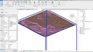
- In this tutorial you will learn how to make 3D topography in Revit from 2D DWG topography using AutoCAD EATTEXT function and Revit import points file.
This helped and you want to thank me? Buy Me a Coffee :)
www.buymeacoff...


![Chlöe - Shake (Feat. Jeremih) [Official Visualizer]](http://i.ytimg.com/vi/aDs_1ufpfv8/mqdefault.jpg)


the hero we need
Still the best video on the topic!
The video was so helpful
Thank you
Wow, Great very useful but i find this explanation too fast to grab quickly, however pausing many times and re-watching it has been solved the issue. Anyways Thank you so much for creating a unique way to extract Topography data from AutoCAD and using this data to make topography in Revit.
Glad it helped! You can always turn on captions and slow down the video by pressing Shift + < or speed up video by pressing Shit + > hope that helps :)
@@BIM-Life Thank you 😊 once again for the reply
Love you Bro, you are the best!
Great tutorial, thank you!
Thank you very much!
Fooking autodesk!
GREAT!!! Thank you very much!!
Cant get past the "select objects in current drawing" part.
I manually selected my topo numbers with a crossing window but the "next" but doesn't allow me to move on to the next step. Any thoughts
Sorry, hard to tell without seeing your screen. Try to do as in video, step by step, maybe you missed something ¯\_(ツ)_/¯
Thank you very much. you save my time
hello, I can't find property ''value'' in my data extraction. could you please tell how can i fix it? thank you in advance
Hi, sorry, I have no idea..
same here
i used the position z for it has our DWG file has its value plotted in z plane.
Excellent ! Thank you so much !!
Glad it helped!
great! thank you a lot
Hello please can you help me with the 2D-3D-topo.dxe file because I'm stuck there because I don't have that file and I can't seem to move forward
Hi, you have to create the dxe file, it's just a setting file that saves settings from EATTEXT command. Essentially you don't need that file to create .CSV file.
its too fast
You can slow down the video by pressing Shift +
Thanks
Do you know how I can do the same but with archicad , cause i tried to follow the steps , but didn’t end up the same way
Sorry, no idea
It’s okey , thanks a lot for the video
Amazing shit, bruh!!
hi i got a problem when i import the points it connects to level 0.00 and makes my 3d look wierd
There could be many issues. You can join Reddit group: www.reddit.com/r/RevitLife/ maybe we can help you there in more detail.
When I check the elevations on revit it shows the easting instead of the elevation. Even though I put my csv in the xyz format.
Not sure what the problem is. There could be many issues. You can join Reddit group: www.reddit.com/r/RevitLife/ maybe we can help you there in more detail.
topography from Latvia
10/10
it was sooo hard to follow and so fast, but still good technique
You can slow down the video by pressing Shift + "
@@BIM-Life thanks for the reply. also, i can import topography but it is always a flat surface. other stuff is exactly the same. how can i solve this?
ah okay the unit was cm intstead of metres. thanks
excellent tips but you are too slow...please be a bit faster next time...
great! Thank you a lot!