Lee Shore Distances

HTML-код
- Опубликовано: 20 авг 2016
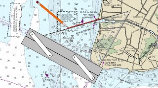
- This describes a paper and pencil navigation procedure for determining in advance the closest point of approach (CPA) to a point of land to leeward of your boat based on the changes that occur in the magnetic bearings to the point of land.


These instructions are at a professional level that exceed most of the videos here on YT. Well done...thanks much.
One of America's finest sailing instructors.
You are one of the finest instructors. Awesome man !
Brings back some old days of surveying math. ha. Those days are long gone with all the coordinate geometry/CoGo, CAD software on the market as you said with the new electronics. How soon we forget! Thanks for the video.
Thank you for introducing Table 18 and its use.
Great information and video!!
sehr lehrreich und gut erklärt . Danke Tom
Very, very good! Thank You!
Thank you very much. That information will be most useful.
In these modern times, we can simply use high school maths to solve the triangle, using the law of sines: a/sin A = b/sin B = c/sin C (and A+B+C=180º). In this case, the CPA distance = d*sin30º*sin50º/sin20º, where d is the distance between the two points where the bearings were taken (1.5nm). 20º is the angle which these points make with the leward point of land. This requires a pocket calculator with sin, but doesn't require digging out the big table 18.
actually, 20º is 50º-30º, so the formula is d*sin(a1)*sin(a2)/sin(a2-a1) where a1 and a2 are the angles from the boat route as explained in the video
@@jdmuys You can also solve the distance off calculations fairly intuitively using two simultaneous equations based on tangents since L1 tan a = L2 tan b, where L1 and L2 are the distances to the CPA and therefore L1 = L2 + (distance traveled between readings). In this case L1 tan 30 = L2 tan 50 and L1 = 1.5Nm + L2
thanks for the video and i will download this table to print it and attach to boat interior. i would prefer to tack
Tom Tursi to me, is a true American hero. Love of God , love of country goes hand in hand.
Liberty, freedom and justice for all. " SAILING IS FREEDOM "
That was very good it will remind me of when I was at nautical school
Great tutorial
I admit to being a pretty inexperienced sailor, but I'm a dreadful mathematician. In this very informative video I understood the procedure to calculate the CPA, but in real life by the time I'd actually worked this out (Referencing text books, tables, notes & brushing up on trigonometry etc) we would have either hit the land or passed it. I think I'd take the cautious route and put in a tack or two to give me more room. In my book, there is no mileage in going quick.
Excellent lecture! I wish I lived in Maryland so that I could attend your courses.
Our navigation courses are taught online live with an instructor... See www.mdschool.com/Navigation.htm
MDS
May I comment ?Your lecture is no doubt well intended and interesting from an academic viewpoint. But you must concede that the accuracy of bearings depends upon the use of a properly constructed gimballed Pelorus. Modern yachts are fitted with a magnetic compass inside a Perspex dome. A gimballed Pelorus cannot be attached to a dome. I have a gimballed Pelorus on board my sloop but there again I had it constructed to my design so that it can be clamped to the handrail before the compass. Again, I am fortunate that my handrail is not curved, as is the norm nowadays. It has a horizontal straight section instead of a curved top, Therefore my gimballed Pelorus clamps easily and can be guaranteed to be aligned on the fore and aft line. Only then can bearings be taken accurately and without guesswork. Yachts are not Navy Vessels that are fitted with Peloruses as a matter of course. The only recourse available to coastal yachtsmen for physical observation and taking horizontal bearings is a handheld bearing compass. These are really only of practical use to determine if an approaching ship presents a collision scenario. Any other use is unsatisfactory. The other alternative is to progressively use a sextant to measure the distance off the height of the given headland if the height is accurately knownand by describing a series of arcs and a course made good tangential to these arcs. But there again, in a heaving sea accuracy is fraught with problems. The prudent action to take is twofold. (1) have an accurate position on approach. (2) tack away by saw tooth increments and verify you are clear of danger by paying attention to soundings. All you explain is very well and good but suitable for the officer of the watch on a warship to execute but too complicated for ordinary yachtsmen and women, I respectfully submit to you.
Binoculars with internal compass - OK - but you cannot use it to calculate azimuths. .
@@albertlabos8400 Azimuth (relative bearing) = magnetic bearing minus magnetic course
No. Azimuth in celestial navigation means the true bearing of a star or planet, period.. Compass bearing means magnetic bearing including deviation (or true bearing plus or minus compass error).. Magnetic bearing equals bearing including variation. Therefore magnetic bearing cleared of variation equals true bearing. If the variation is westerly subtract. If it is easterly add to obtain true bearing. True bearing is a bearing free of variation, deviation and hence free of compass or magnetic error.