Clip shapefile in QGIS | clipping in GQIS

HTML-код
- Опубликовано: 4 янв 2024
- Clip Tool
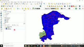
To use the Clip tool, you will need 2 shapefiles. At least in some versions of QGIS, they will need to be in the same projection. For this example, I have nationwide census tracts and a North Carolina state boundary, and I want a layer of just the census tracts in North Carolina. This tool creates a new shapefile whereas the Spatial Query only displays the new information. (With the Spatial Query tool you have not changed the dataset or created a new shapefile, it is only a visual change.)
Click the Vector menu at the top of the QGIS program, mouse-over Geoprocessing Tools, and click Clip...
There are 3 areas to this tool you will need to be concerned with:
Input vector layer: the larger shapefile
Clip layer: the boundary you want to clip the input layer to. This will typically be a state, country, etc.
Output shapefile: the folder where you want to save the new shapefile to and the name of the new shapefile
For this example, the input vector layer is the nationwide census tracts, the clip layer is the NC state boundary.
How to Extract Smaller Areas From A larger Shapefile in QGIS