Nice in-depth video on creating a mapping mission which I've personally never done yet and a possible work around for not being able to easily find the flight route and be able to import it into SarTopo. Great work.
Love the video, I find it great. Only critique I have about your flight is that you release the control sticks after every turn which will wear down the internal springs causing premature failure of the control stick module (had it happen to me after 35 hours on M30T)
Yep, I like to think it’s very rare that I flick the sticks, but it definitely happens. A few instances here but also a lot of what you hear is the zoom/gimbal angle wheels. Wasn’t really paying attention here but that internal mic really picks up every little mistake 😂. Thanks for the input!
Setting up mapping missions in Google Earth and then loading them into the controller seems to be a very promising way of covering areas plus leaves a way to determine what has been searched.
True. There are a few options to generate a mission. What I didn't state verbally(but did in a caption) was that I was looking for an on-site offline method to easily and quickly setup a mission with just the RC Pro and current features. I'm picturing a scenario where there is no cell coverage in the middle of nowhere and the team leader hands me the coordinates for my particular search area. I appreciate your comment and will definitely look into Google Earth and its potential.
@@STRThermal I am in my beginning stages of setting up missions for this as well. I am in the process of getting Loc8 software. Personally I believe that in many situations it will be a game changer. I figured out a few weeks ago how o do the missions on Google Earth and then load them to the controller. I figured that if we don't have cell service we could possibly get to the area and figure out what needed searching. especially on a large scale search and take the laptop to a place where we could get cell service and download the missions that looked promising from Google earth and upload them to the controller. Plus is you find something and ground resources would have trouble getting to it you can set up a mission and send the drone back to that location. I guess it is a learning process for us all since we are all in different pars of the country and deal with different terrains ect. I use Pilot app for the missions.
The issue with waypoints is the setup, generating the "grid" quickly. I'm looking into it as another possible alternative. So glad you're watching and welcome to the M3T family.
Really good video. I'm a new drone pilot with a Mavic 3 pro with RC pro controller but no thermal. Will all the apps you mention work with my unit? I want to do search ,specifically mountains. I have a lot to learn.
I just tried it with waypoints. seems like it would work and may be relatively easy as a mapping mission without the constant photos. I couldn't do to much where I am currently (city). stopping and resuming didn't seem to be easy but didn't fly but a minute due to space. gonna try linear and see if that works
Yeah it’ll work for sure…but if you’re doing SAR or a deer survey of 1000 acres, that’s a lot of points to have to manually enter. That’s the only issue I see with the waypoint mission. Still learning here too so let me know what else you learn.
Probably asked and answered, is there a recommended height for missions like open field fugitive searches? I see in this video you are operating at 300' AGL. Thoughts?
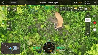
Depends on the cover…but in general I can search from 300-400ft. A human, deer, etc show up well….higher altitude equals larger field of view and faster ground covered. Only time I’ll search lower is if it’s thick and I know I’ll need to move around to see under a bush or tree. In open ground(open hardwoods, fields, etc), basically stuff that is easy to look through, higher works just fine. Now if you’re looking for a body/carcass that may have lost heat(24 hrs+) you may also fly lower to pick up those finer heat signature differences. You’ll see in a lot of my videos I’m looking at deer initially from 350-400ft and they are easy to spot.
@@STRThermal Thank you very much for the advice and all the work you have put into your videos. The 3T is a pretty impressive aircraft, already had some overwatch type success.
Im starting a program for my department. Thanks for the helpful video! Lots to think about as far as workflows. I do have one question maybe someone could help, am I able to plan a mission outside of the app - for example on my desktop, and then send that to the controller?
Great question. I’m focused on improving the quick on-site and free methods…where you only have the basic search grid coordinates and your drone/controller. But DJI Flight Hub 2 can be used to not only plan your missions but also for mission-sharing with a team of pilots and mission streaming for onlookers. I think there are other similar resources, so search for flight hub2 and compatible methods. I will get into this aspect soon. Very glad you found my video helpful!
I'm almost positive you can set the camera to take a photo at a set time interval or distance interval when uploading the mission to the drone. At that point you can set the distance to the longest interval possible and take any desired photos manually in-between. I will check this the next time I fly. Also you can also set an isotherm alarm to alert you of Delta T's or max temp reading. Make sure to check what your own body heat is reading from the height you plan to fly and compensate because temperature readings are NOT accurate at all since you cannot set the ambient temperature, spot size, or distance properly on this thermal camera. Atmospheric Attenuation from humidity, dust and other particles will also interfere with your thermal temps and readings the higher you fly.
Time or distance interval shots are still limited by overlap settings and the min is 10%. There was a method we found after making this video to pause photo collection, a work around, but DJI had disabled that feature. I don’t use isotherms(terrible idea once you understand how the software works) or alarms. You never know what someone is wearing(insulation), hiding under(partial visibility), etc on top of the apparent vs actual temp and environmental factors you mentioned. So trained eyes are best for finding the anomalies in my opinion.
Thanks for the great video, I have a m30t and m3t for fire fighting. It would be good to be able to export your flight data as a kml file, keep up the good work.
Thank you! You can export your dropped pinpoints as a kml. It’s also my understanding(I have not done this) that you can use certain data services to extract your flight log(path) data.
Good question. It’s not that way in all my videos(I don’t pay much attention tbh). But I suspect I tapped the screen to access it. I’ll check when I get home.
Mapping is usually for surveying. It helps create an ortho map to see later, which you can easily filter out any temperature reading you may be looking for.
That’s correct, and we know this. But for search and rescue style operations, we need a different style of autonomous flight mode(using pilot 2) that neither waypoints nor mapping does well.
Interesting but you made that harder for yourself. You are now manually flying, dropping pinpoints as you go. The integrity of the search is lost as you drift off the pattern. We use the waypoint method, creating the route using the distances of each leg to construct the grid. You can program the speed, height etc. No photos, using the two finger swipe down to clear all the data so you can just concentrate on the job, locating what you are searching for.
@MrTeabag45 As a pilot, dropping a random waypoint while flying a 500 acre grid search is not “harder” nor does it affect the integrity of the search. I only do it in case I inadvertently back out to the main menu and lose the flight path(a known issue that I have reported to DJI and they have yet to fix). The dropped pin points are a way to show what I have covered and what I haven’t, nothing more. Waypoints mode is great for small flight plans or something you will do frequently(a security flight plans for instance) but not for large acreage searches.
@@STRThermal Also as a professional pilot of 40 years, 20000hrs and multiple SARs I’ll stick with the waypoint method. You described the disadvantages of the mapping function well but fail to realise the importance of automated flights especially when operating for extended periods in large search areas.


Nice in-depth video on creating a mapping mission which I've personally never done yet and a possible work around for not being able to easily find the flight route and be able to import it into SarTopo. Great work.
Thanks Bill. Hope it was helpful or, at least, thought provoking.
That’s Awesome! Have a great weekend! 🤗❤️✨
Love the video, I find it great. Only critique I have about your flight is that you release the control sticks after every turn which will wear down the internal springs causing premature failure of the control stick module (had it happen to me after 35 hours on M30T)
Yep, I like to think it’s very rare that I flick the sticks, but it definitely happens. A few instances here but also a lot of what you hear is the zoom/gimbal angle wheels. Wasn’t really paying attention here but that internal mic really picks up every little mistake 😂. Thanks for the input!
Setting up mapping missions in Google Earth and then loading them into the controller seems to be a very promising way of covering areas plus leaves a way to determine what has been searched.
True. There are a few options to generate a mission. What I didn't state verbally(but did in a caption) was that I was looking for an on-site offline method to easily and quickly setup a mission with just the RC Pro and current features. I'm picturing a scenario where there is no cell coverage in the middle of nowhere and the team leader hands me the coordinates for my particular search area. I appreciate your comment and will definitely look into Google Earth and its potential.
@@STRThermal I am in my beginning stages of setting up missions for this as well. I am in the process of getting Loc8 software. Personally I believe that in many situations it will be a game changer. I figured out a few weeks ago how o do the missions on Google Earth and then load them to the controller. I figured that if we don't have cell service we could possibly get to the area and figure out what needed searching. especially on a large scale search and take the laptop to a place where we could get cell service and download the missions that looked promising from Google earth and upload them to the controller. Plus is you find something and ground resources would have trouble getting to it you can set up a mission and send the drone back to that location. I guess it is a learning process for us all since we are all in different pars of the country and deal with different terrains ect.
I use Pilot app for the missions.
@@jekjr1957 Never heard of Loc8. I’m interested to hear what you think of it.
@@STRThermal ruclips.net/video/TL9N-PWMlm0/видео.html Older video on it but it gives an idea.
Loc8 seems cool!
what about using waypoints mode for search? I just got a 3t and have been watching your vids for deer recovery
The issue with waypoints is the setup, generating the "grid" quickly. I'm looking into it as another possible alternative. So glad you're watching and welcome to the M3T family.
Really good video. I'm a new drone pilot with a Mavic 3 pro with RC pro controller but no thermal. Will all the apps you mention work with my unit? I want to do search ,specifically mountains. I have a lot to learn.
I don't personally have a regular RC Pro and I know there are some differences but you can still install 3rd party apps.
I just tried it with waypoints. seems like it would work and may be relatively easy as a mapping mission without the constant photos. I couldn't do to much where I am currently (city). stopping and resuming didn't seem to be easy but didn't fly but a minute due to space. gonna try linear and see if that works
Yeah it’ll work for sure…but if you’re doing SAR or a deer survey of 1000 acres, that’s a lot of points to have to manually enter. That’s the only issue I see with the waypoint mission. Still learning here too so let me know what else you learn.
Probably asked and answered, is there a recommended height for missions like open field fugitive searches? I see in this video you are operating at 300' AGL. Thoughts?
Depends on the cover…but in general I can search from 300-400ft. A human, deer, etc show up well….higher altitude equals larger field of view and faster ground covered. Only time I’ll search lower is if it’s thick and I know I’ll need to move around to see under a bush or tree. In open ground(open hardwoods, fields, etc), basically stuff that is easy to look through, higher works just fine. Now if you’re looking for a body/carcass that may have lost heat(24 hrs+) you may also fly lower to pick up those finer heat signature differences. You’ll see in a lot of my videos I’m looking at deer initially from 350-400ft and they are easy to spot.
@@STRThermal Thank you very much for the advice and all the work you have put into your videos. The 3T is a pretty impressive aircraft, already had some overwatch type success.
@@ColoBeauPhotog Thank you! I’m glad you’ve found the content helpful.
Im starting a program for my department. Thanks for the helpful video! Lots to think about as far as workflows. I do have one question maybe someone could help, am I able to plan a mission outside of the app - for example on my desktop, and then send that to the controller?
Great question. I’m focused on improving the quick on-site and free methods…where you only have the basic search grid coordinates and your drone/controller. But DJI Flight Hub 2 can be used to not only plan your missions but also for mission-sharing with a team of pilots and mission streaming for onlookers. I think there are other similar resources, so search for flight hub2 and compatible methods. I will get into this aspect soon. Very glad you found my video helpful!
I'm almost positive you can set the camera to take a photo at a set time interval or distance interval when uploading the mission to the drone. At that point you can set the distance to the longest interval possible and take any desired photos manually in-between. I will check this the next time I fly. Also you can also set an isotherm alarm to alert you of Delta T's or max temp reading. Make sure to check what your own body heat is reading from the height you plan to fly and compensate because temperature readings are NOT accurate at all since you cannot set the ambient temperature, spot size, or distance properly on this thermal camera. Atmospheric Attenuation from humidity, dust and other particles will also interfere with your thermal temps and readings the higher you fly.
Time or distance interval shots are still limited by overlap settings and the min is 10%. There was a method we found after making this video to pause photo collection, a work around, but DJI had disabled that feature. I don’t use isotherms(terrible idea once you understand how the software works) or alarms. You never know what someone is wearing(insulation), hiding under(partial visibility), etc on top of the apparent vs actual temp and environmental factors you mentioned. So trained eyes are best for finding the anomalies in my opinion.
Thanks for the great video, I have a m30t and m3t for fire fighting. It would be good to be able to export your flight data as a kml file, keep up the good work.
Thank you! You can export your dropped pinpoints as a kml. It’s also my understanding(I have not done this) that you can use certain data services to extract your flight log(path) data.
You can, into Google earth.
How do you get the temp cursor to stay in the middle?
Good question. It’s not that way in all my videos(I don’t pay much attention tbh). But I suspect I tapped the screen to access it. I’ll check when I get home.
Thanks!!!! Great videos!!!!!
@@hyp7 I appreciate it, man!
@@hyp7 So looks like I must have just tapped the reticle to get the temp measure at the center. No auto centering method that I can figure out.
Thank you I'll definitely give it a try, now to order the jt light !!!!
Mapping is usually for surveying. It helps create an ortho map to see later, which you can easily filter out any temperature reading you may be looking for.
That’s correct, and we know this. But for search and rescue style operations, we need a different style of autonomous flight mode(using pilot 2) that neither waypoints nor mapping does well.
i need to peoteft from government draws
Interesting but you made that harder for yourself. You are now manually flying, dropping pinpoints as you go. The integrity of the search is lost as you drift off the pattern. We use the waypoint method, creating the route using the distances of each leg to construct the grid. You can program the speed, height etc. No photos, using the two finger swipe down to clear all the data so you can just concentrate on the job, locating what you are searching for.
@MrTeabag45 As a pilot, dropping a random waypoint while flying a 500 acre grid search is not “harder” nor does it affect the integrity of the search. I only do it in case I inadvertently back out to the main menu and lose the flight path(a known issue that I have reported to DJI and they have yet to fix). The dropped pin points are a way to show what I have covered and what I haven’t, nothing more. Waypoints mode is great for small flight plans or something you will do frequently(a security flight plans for instance) but not for large acreage searches.
@@STRThermal Also as a professional pilot of 40 years, 20000hrs and multiple SARs I’ll stick with the waypoint method. You described the disadvantages of the mapping function well but fail to realise the importance of automated flights especially when operating for extended periods in large search areas.