Drones in Forest Management

HTML-код
- Опубликовано: 7 сен 2024
- Have you ever heard about using drones for forest management?
Researchers at UBC's Faculty of Forestry describe how drones are a great tool for helping us to understand more about our forests and improve forest practices.
Find us on twitter @IRSS_UBC
Find Tristan on twitter @GoodbodyT
Royalty Free Music Credit:
www.bensound.c...
Video Production:
Megan Poblacion
-----------------------
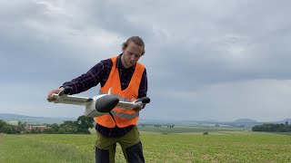
The integrated remote sensing studio at UBC’s faculty of forestry has been actively involved in researching how remotely piloted aerial systems, or drones, to be used in a forestry context. Drones have a unique ability to acquire high quality image and video products that are tailored to the requirements of users. The use of this technology in forestry is becoming widespread due to their high quality data products, low cost, and ability to be deployed quickly. Drones come in a variety of shapes and sizes, with particular models and airframe types being used for different purposes.
After learning how to operate a drone safely, a forester can provide a variety of important inventory information. With a single imagery acquisition, drones can capture spatial information about the distribution of forests, like where trees are on the landscape, spectral information, about how forests look, like are trees healthy or not, and details about forest structure like how tall trees are or how much ground cover they may have.
A single acquisition is useful, but the exceptional value of drones becomes apparent when multiple data captures are conducted through time. This allows for changes in the landscape, like growth and disturbances, to be detected and translated into forest inventories. Drones therefore provide a cost-effective and accurate means of monitoring stem development, characterizing changes, and updating forest inventory information to be as real-time as possible. Having better knowledge of our forests is important for mitigating risks associated with climate change, enhancing our ability to effectively manage non-timber resources, like wildlife habitat, water, and carbon, and also sustainably develop the timber resource sector at the same time.
Compatible sensors are abundant, with low-cost cameras like those on a smartphone being actively used, and alternative sensors like LiDAR being more prevalent. With all this being said, there are a few limitations to drones. Current batteries limit flights between 15 minutes to an hour, and the legislation is evolving quickly, drones must currently be operated within visual line of site.
There is, however, no doubt that these tools have exceptional value for improving forest inventory frameworks. Their active development means that their potential applications will continue to expand, helping to improve forest management into the future.
If you liked this video, or want to learn more, feel free to reach out to researchers behind this project on twitter at @IRSS_UBC


Awesome video Tristan! Clear and concise plain language summary of the topic :)