Thank you so much, Mr Tursi. You explained it so very well. I find the way you teach clear and precise which is evidently the result of a vast rich experience you must have had at sea and in your teaching career. It is a privilege to learn from you indeed.
That was amazing coherent. I’ve never touched this subject before and was able to understand all the way through as I took notes along with it. Great material, very grateful. Thanks!
Excellent video, to-the-point and a real service to serious sailors who want to learn celestial or, like me, whose celestial navigation skills have rusted in these days of helm mounted GPS chart plotters! I've always feared, while hundreds of miles offshore, loss of electronics , say, from a lightning strike, etc. Thanks for posting this!
This is a really nice overview! If you have a computer with Excel (or equivalent) available, you can use it to perform the requisite calculations; find the website called “Navigation Spreadsheets” and download the free spreadsheets. Once you have those, you can then use them any time, even without an Internet connection.
This is good. But I would argue that you shouldn't rely on any electronics while offshore. I find it nearly as fast just to use the almanac and sight reduction tables.
Now I'm getting it! I've tried reading books (not yours) and used other sources, but none made it so clear. I'm a visual learner and your graphics (and audio) helped clear up so much for me. I may enroll or at least buy the text. Thanks again
It’s not necessary to have a Single Sideband Radio to receive the WWV(H) time signals. Any shortwave radio which can be tuned to 5, 10 or 15 MHz can be used. There are many inexpensive portable shortwave radios that will serve well for time signal reception. C. Crane and Grundig radios come to mind.
Good day Sir, Before anything, I would like to thank you for uploading on the Internet all the videos about navigation. I have learned from them, they are very good. There's a question I would like to ask if possible...I read a lot of materials about Celestial Navigation and there's one thing that I could not understand. They're saying like this: "We're taking bearings to the Star","We're taking bearings to the Pole Star" or whatever the celestial body is. My question is how we could take bearings to one star using the alidade upon the Gyro repeater?? That star is supposed to be on the sky. Its not the same thing like taking bearing to a buoy or a beacon lying down on the horizon. Please explain this to me. Its very very important to me. Unfortunately, nobody have shown that to us. Just by the books but not practically which is way much important than reading. Thank you very much for your kind support. You are the best.
I can only guess that your references are talking about taking a sextant shot, but I'd need to see their entire quote to know for sure. Send us an email with more details, and we'll attempt to clarify... MDS
Thanks for posting this. Very similar to the approach that I learnt. Quick question: why are so many offshore navigators happy to use a noon sight to update their DR position, when an accurate longitude is so difficult to determine using this method ? (e.g., interpolating multiple sights overhead).
I personally think it's harder to use the noon sight since multiple shots are required while on deck in a possibly precarious position. Also, the noon sight is not at all accurate for longitude since the moment of LAN is whizzing by you at a very high rate of speed and missing that moment by even a minute can lead to a 30 or 40 mile longitude error. I prefer to keep a good DR, take timed shots and plot running fixes... T
Great presentation thank you! On the cruise from Norfolk to St. Thomas, you would prefer to plot on 5 DMA charts: 922-926 instead of plotting on Universal Plotting Sheets, then transferring your positions to a small scale chart such as NGA Chart 108? I'm curious because I am just learning this skill/art and I noticed your comment about this issue at about 2:20. Thanks!
The 108 chart can give you the big picture, but it's scale is too small to do any meaningful daily navigation such as running fixes, plus you would be doing extra work transferring to/from the universal plotting sheets. Better to stick with the DMA charts and have one stop shopping for all of your navigation practice... T
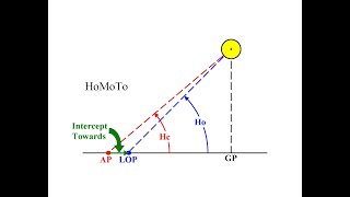
The AP is never assumed to be your actual position. It is a carefully selected artificial position nearby, chosen to make sight reduction simpler (i.e., so you don't have to interpolate for minutes of LHA, and so you can solve the spherical triangle without interpolating degrees of latitude).
Superb in all ways. BUT: Why not just always have, and keep, your boat's chronometer set to Greenwich Time and thus avoid getting a hernia while in the middle of the ocean from thinking about all of the choreography of the time zones and their borders? What am missing?
I got a question for you. So since ancient Greek, our ancestors have used celestial navigation. In celestial navigation, we had to assume the stars are fixed on fictitious celestial sphere. But polaris has been in same position for thousands of years. 1000 years ago, people use this imaginary celestial sphere, and the ancient mariners navigate around the ocean. How is this possible? Only in modern astronomy, celestial sphere is imaginary Ancient mariners actually believed the stars are fixed on the dome Don't you think that our ancestors are actually right ?
1000s of years ago (as the Egyptians of the middle kingdom observed) Thuban was the north star. The celestial north alignment moves on the great cycle of the earth's wobble or precession. In 4000 years brilliant Altair (if I recall correctly) will be the likely candidate for the north star.


A very fine presentation delivered in a very relaxed style from a gentlemen who obviously knows marine navigation inside out.
Bravo
Thank you Captain for laying down in a patient and understandable way the basics for this fascinating topic of finding your way at sea.
Thank you so much, Mr Tursi. You explained it so very well. I find the way you teach clear and precise which is evidently the result of a vast rich experience you must have had at sea and in your teaching career. It is a privilege to learn from you indeed.
That was amazing coherent. I’ve never touched this subject before and was able to understand all the way through as I took notes along with it. Great material, very grateful. Thanks!
Excellent video, to-the-point and a real service to serious sailors who want to learn celestial or, like me, whose celestial navigation skills have rusted in these days of helm mounted GPS chart plotters! I've always feared, while hundreds of miles offshore, loss of electronics , say, from a lightning strike, etc. Thanks for posting this!
Thank you, Capt Tom. Now I just need to watch this 10 times! You well connected the dots (pun intended) for practice and for understanding.
This is a really nice overview! If you have a computer with Excel (or equivalent) available, you can use it to perform the requisite calculations; find the website called “Navigation Spreadsheets” and download the free spreadsheets. Once you have those, you can then use them any time, even without an Internet connection.
This is good. But I would argue that you shouldn't rely on any electronics while offshore. I find it nearly as fast just to use the almanac and sight reduction tables.
Excellent video. You are are a great teacher. Wish to learn more from you. Thanks and good sailing.
This can hardly be explained better. Thank you very much !!!
Now I'm getting it! I've tried reading books (not yours) and used other sources, but none made it so clear. I'm a visual learner and your graphics (and audio) helped clear up so much for me. I may enroll or at least buy the text. Thanks again
It’s not necessary to have a Single Sideband Radio to receive the WWV(H) time signals. Any shortwave radio which can be tuned to 5, 10 or 15 MHz can be used. There are many inexpensive portable shortwave radios that will serve well for time signal reception. C. Crane and Grundig radios come to mind.
Outstanding presentation! Thank you Captain Tom!
This was a great hour plus video from a great teacher -- thanks!
Thanks, this was very informative and helpfull
Thank you absolutely brilliant explication
Good day Sir,
Before anything, I would like to thank you for uploading on the Internet all the videos about navigation. I have learned from them, they are very good.
There's a question I would like to ask if possible...I read a lot of materials about Celestial Navigation and there's one thing that I could not understand. They're saying like this: "We're taking bearings to the Star","We're taking bearings to the Pole Star" or whatever the celestial body is.
My question is how we could take bearings to one star using the alidade upon the Gyro repeater?? That star is supposed to be on the sky. Its not the same thing like taking bearing to a buoy or a beacon lying down on the horizon.
Please explain this to me. Its very very important to me.
Unfortunately, nobody have shown that to us. Just by the books but not practically which is way much important than reading.
Thank you very much for your kind support. You are the best.
I can only guess that your references are talking about taking a sextant shot, but I'd need to see their entire quote to know for sure. Send us an email with more details, and we'll attempt to clarify... MDS
Thank you for this video!
Thanks for posting this. Very similar to the approach that I learnt. Quick question: why are so many offshore navigators happy to use a noon sight to update their DR position, when an accurate longitude is so difficult to determine using this method ? (e.g., interpolating multiple sights overhead).
I personally think it's harder to use the noon sight since multiple shots are required while on deck in a possibly precarious position. Also, the noon sight is not at all accurate for longitude since the moment of LAN is whizzing by you at a very high rate of speed and missing that moment by even a minute can lead to a 30 or 40 mile longitude error. I prefer to keep a good DR, take timed shots and plot running fixes... T
Great presentation thank you! On the cruise from Norfolk to St. Thomas, you would prefer to plot on 5 DMA charts: 922-926 instead of plotting on Universal Plotting Sheets, then transferring your positions to a small scale chart such as NGA Chart 108? I'm curious because I am just learning this skill/art and I noticed your comment about this issue at about 2:20. Thanks!
The 108 chart can give you the big picture, but it's scale is too small to do any meaningful daily navigation such as running fixes, plus you would be doing extra work transferring to/from the universal plotting sheets. Better to stick with the DMA charts and have one stop shopping for all of your navigation practice... T
How do you "KNOW" where the location of your AP is when you are in the middle of the ocean?
Your Dead Reckoning plot (DR) that you keep up to date tells you approximately where you are, and you base your AP (assumed position) on the DR
The AP is never assumed to be your actual position. It is a carefully selected artificial position nearby, chosen to make sight reduction simpler (i.e., so you don't have to interpolate for minutes of LHA, and so you can solve the spherical triangle without interpolating degrees of latitude).
Superb in all ways. BUT: Why not just always have, and keep, your boat's chronometer set to Greenwich Time and thus avoid getting a hernia while in the middle of the ocean from thinking about all of the choreography of the time zones and their borders? What am missing?
We do that, but students need to know how to make the conversions for depth of knowledge and personal gratification... T
thnx:)
nice video
I got a question for you. So since ancient Greek, our ancestors have used celestial navigation.
In celestial navigation, we had to assume the stars are fixed on fictitious celestial sphere.
But polaris has been in same position for thousands of years.
1000 years ago, people use this imaginary celestial sphere, and the ancient mariners navigate around the ocean. How is this possible? Only in modern astronomy, celestial sphere is imaginary
Ancient mariners actually believed the stars are fixed on the dome
Don't you think that our ancestors are actually right ?
1000s of years ago (as the Egyptians of the middle kingdom observed) Thuban was the north star. The celestial north alignment moves on the great cycle of the earth's wobble or precession. In 4000 years brilliant Altair (if I recall correctly) will be the likely candidate for the north star.