Slope, Aspect, Contour , Hillshade Map in ArcGIS
US
Войти
Flood Risk Simulation Map of an area using ArcGIS
9:07
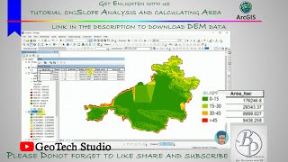
Slope Analysis from DEM in ArcGIS || Slope-Wise Area Calculation || @GeoTech Studio
21:42
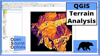
QGIS Terrain Analysis: hillshade, slope, aspect (Version 3.x)
13:05
Hollywood - Peso Pluma, Estevan Plazola (Video Oficial)
04:49
Avengers wake up, Marvel Rivals is fire
18:15
I GOT BULLIED INTO CUTTING MY HAIR :(
22:55
Slope, Aspect, Contour , Hillshade Map in ArcGIS
GIS & RS Solution
Подписаться
70 тыс.
Скачать
Готовим ссылку...
Просмотров 153 тыс.
0
0
Добавить в
Мой плейлист
Посмотреть позже
Поделиться
Поделиться
HTML-код
Размер видео:
1280 X 720
853 X 480
640 X 360
Показать панель управления
Автовоспроизведение
Автоповтор
Опубликовано: 18 янв 2025
Комментарии • 59
Следующие
Автовоспроизведение
9:07
Flood Risk Simulation Map of an area using ArcGIS
GIS & RS Solution
Просмотров 73 тыс.
21:42
Slope Analysis from DEM in ArcGIS || Slope-Wise Area Calculation || @GeoTech Studio
GeoTech Studio
Просмотров 38 тыс.
13:05
QGIS Terrain Analysis: hillshade, slope, aspect (Version 3.x)
Geospatial School
Просмотров 76 тыс.
04:49
Hollywood - Peso Pluma, Estevan Plazola (Video Oficial)
Peso Pluma
Просмотров 4,1 млн
18:15
Avengers wake up, Marvel Rivals is fire
zanny
Просмотров 1,1 млн
22:55
I GOT BULLIED INTO CUTTING MY HAIR :(
KillSMartyr
Просмотров 211 тыс.
02:48
Imagine Dragons - Take Me To The Beach (feat. Ado) (Official Lyric Video)
ImagineDragonsVEVO
Просмотров 2 млн
28:15
Slope, Hillshade, Aspect, curvature & elevation map From DEM in ArcGIS
GIS with Raja Usama
Просмотров 16 тыс.
9:12
How to extract contour lines And DEM from Google Earth
Made 4 Geek
Просмотров 910 тыс.
13:21
OSINT At Home #9 - Top 4 Free Satellite Imagery Sources
Bendobrown
Просмотров 1,6 млн
19:55
Nepal's Mad Honey That Causes Hallucinations (They climb to go insane)
Ruhi Çenet
Просмотров 38 млн
12:05
Videoguide - Import Terrain, BlenderGIS, Google Maps, Landscape, Buildings, Geographic Information
jbdtube
Просмотров 69 тыс.
16:58
3D Visualizations in ArcGIS Pro
GeoDelta Labs
Просмотров 12 тыс.
8:44
Slope, Aspect, and Curvature
Thomas Pingel
Просмотров 34 тыс.
27:14
Transformers (how LLMs work) explained visually | DL5
3Blue1Brown
Просмотров 4,4 млн
12:54
Lineament and Lineament Density Map Preparation in Arc GIS
Gis and Remote Sensing Basics
Просмотров 49 тыс.
00:48
Oh my god! Who is the monster! #Joker#Harley Quinn#Angel
超人夫妇
Просмотров 2,4 млн
08:21
Расстреливают свои же. Что происходит в российской армии?
Михаил Ходорковский
Просмотров 228 тыс.
52:29
ДИАНА КАК МАМА!!! ХОРОШАЯ ИЛИ ПЛОХАЯ МАМА ДЛЯ ДАНЫ?
Lady Diana VLOG
Просмотров 284 тыс.
1:12:34
Когда нас ждут хорошие времена? Реформы в России, кризис в США, бунт ИИ. Астролог Константин Дараган
Сама Меньшова
Просмотров 641 тыс.
1:22:35
🔴 Пресс-конференция после UFC 311: Махачев vs Мойкано
UFC Eurasia
Просмотров 424 тыс.
00:19
А как мать узнала, куда нести щенка?
Новостной Гусь
Просмотров 1 млн
00:19
💳💳💳 #galkina_anechka #ice #icequeen #winter
Galkina_Anechka
Просмотров 3,5 млн
00:24
I'm back on this stage again, I'm still as handsome as ever【Zhang Xuanrui】
Hao Hao Zhang
Просмотров 6 млн