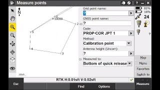
Integrated Surveying with Trimble Access
US
Войти
Linework & Measure Codes in Trimble Access
25:16
GPS Site Calibration
17:02
Why should you use CRM? | Subilal K
1:33
I 3D Printed a $1,500 Chair
23:09
Jason Segel Breaks Down His Most Iconic Characters
28:00
Avengers wake up, Marvel Rivals is fire
18:15
Integrated Surveying with Trimble Access
Frontier Precision
Подписаться
7 тыс.
Скачать
Готовим ссылку...
Просмотров 21 тыс.
0
0
Добавить в
Мой плейлист
Посмотреть позже
Поделиться
Поделиться
HTML-код
Размер видео:
1280 X 720
853 X 480
640 X 360
Показать панель управления
Автовоспроизведение
Автоповтор
Опубликовано: 6 янв 2025
Комментарии •
Следующие
Автовоспроизведение
25:16
Linework & Measure Codes in Trimble Access
Frontier Precision
Просмотров 37 тыс.
17:02
GPS Site Calibration
Surveying With Robert
Просмотров 48 тыс.
1:33
Why should you use CRM? | Subilal K
Subilal K
Просмотров 7
23:09
I 3D Printed a $1,500 Chair
Morley Kert
Просмотров 327 тыс.
28:00
Jason Segel Breaks Down His Most Iconic Characters
GQ
Просмотров 230 тыс.
18:15
Avengers wake up, Marvel Rivals is fire
zanny
Просмотров 1,1 млн
19:48
I Bought Gifts In ONE COLOR For My Sister!
Hudson Matter
Просмотров 643 тыс.
19:59
Offset and Elevation Layout with Robotic Total Station
Ironworker Survey and Layout
Просмотров 37 тыс.
31:57
Jobsite Calibration to Local Coordinates Using Trimble Access
Allen Instruments
Просмотров 27 тыс.
17:32
Integrated Surveying using a S5 Robot and R10 GPS
Surveying With Robert
Просмотров 26 тыс.
16:23
RTK Face off - Trimble vs Emlid vs Spectra
The 3rd Dimension
Просмотров 6 тыс.
28:20
Combining Total Station, GPS & Levelling Survey Data
The 3rd Dimension
Просмотров 2,6 тыс.
18:05
AI powered Total Station
Rami Tamimi
Просмотров 7 тыс.
9:36
Trimble Integrated Surveying - Precise Road Stakeout with Station Elevation
Frontier Precision
Просмотров 6 тыс.
15:05
How to Find the Property Lines of Any Home (Version 4)
Mark Scheller
Просмотров 225 тыс.
11:53
GPS Search for surveying with a Trimble Robotic Total Station
Frontier Precision
Просмотров 30 тыс.
02:53
INTER-MILAN 2-3 | HIGHLIGHTS | Abraham Scores Last-Minute Winner! | EA SPORTS FC Supercup 2025
Serie A
Просмотров 2,7 млн
00:56
Особенность игрока № 001
Star Family
Просмотров 73 тыс.
00:57
НЕВОЗМОЖНЫЙ ФОКУС С КАЛЬКУЛЯТОРОМ
Masomka
Просмотров 117 тыс.
00:16
OLLIE BEFORE NERF WAS BROKEN... 💀💀💀
Lapsa
Просмотров 1,5 млн
00:14
Присвоил чаевые
Новостной Гусь
Просмотров 849 тыс.
10:56
О НЕТ! У ТЕБЯ ЕСТЬ 5 МИНУТ ЧТОБЫ СПРЯТАТЬСЯ ОТ МИМИКА ЗА ОКНОМ В МАЙНКРАФТ!
ВЛАДУС
Просмотров 570 тыс.
00:52
В конце прЭкол4ik
Mikhail Boldurev
Просмотров 1,6 млн
00:37
SPRUNKI Test IQ Challenge: Help Pinki CHOOSE THE RIGHT PORTAL
Wee Animation
Просмотров 9 млн