Это видео недоступно.
Сожалеем об этом.
Introducing Coordinate Systems and Map Projections

HTML-код
- Опубликовано: 15 авг 2024
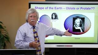
- Why should you care about coordinate systems and map projections? The coordinate system is a fundamental part of GIS data. Without the coordinate system, you cannot overlay or analyze two datasets properly. A map projection is an integral part of a projected coordinate system which strongly affects your analyses and the look of your data. Learn about different coordinate systems; figure out an unknown coordinate system, and check out various map projections.
--------------------------------------------------------------------------------------------------------------------------
Follow us on Social Media!
Twitter: / esri
Facebook: / esrigis
LinkedIn: / esri
Instagram: / esrigram
The Science of Where: www.esri.com


![Finesse2Tymes & Og Boo Dirty - Real Recognize Real [Official Music Video]](http://i.ytimg.com/vi/3xb4bl5PWF8/mqdefault.jpg)


This dude said ''just for funzies'' at 37:29 .. @Esri Events give this man a raise
Excellent!, just one thing, on minute 3:42 is 80 degrees east and 50 degrees north for the Point P rather than 80 degrees north.
love this, thannk you for posting
Hi I am using ArcGIS core in angular and I am plotting some graphics on map and when I am reading x and y coordinates I am getting that in 8 digits, is there any other way where I can get that same x ,y coordinates with less that 8 digits .in my code it is showing wkid 3857 .
Because I am using that coordinates for futher processing with some other applications.
Any help will be appreciated.
Thanks in advance
Thanks in a million. Great stuff.
2:15 Can anyone explain this? I didn't get it (I didn't understand the two options of km with different values)
Excellent!
Good day , pleas can i have this power point presentation , i am using it to study ,thanks
I know I'm very late with the response... but yes in case someone else needs it: proceedings.esri.com/library/userconf/devsummit19/papers/DevSummitPS_66.pdf
Hello everyone! So I'm taking an intro to GIS class at my college and I'm trying to find any good forums or groups that I would be able to ask questions and problem solve stuff? I'm trying to find a good community forum that I could ask this question that my textbook had at the end of the chapter on coordinate systems!
"In a Geographic Coordinate System all properties are distorted unlike a Projected Coordinate System, why might this be the case?" 🤔!
I'm having a bit of a hard time thinking through this and I feel like it's something obvious that I'm just overlooking 😂! So if anyone is able to help me on this and/or able to suggest some good GIS forums I might find useful this semester I'd be truly grateful 🙏🏻!!
Exellent
Strange reading signal means future values,,, came back ghost reading guess place bet on wheel deck and consideration of odds. For/against house wins again, closed windows. See'em bet, popular true guess, combination \permutaions. John.
The title isn't accurate. You definitely need some GIS knowledge to understand the contents here...
T ⁰