Sir do you have a video tutorial sir on leveling surveying and how to compute for elevation from a given benchmark? And do you have a tutorial on how to compute manual surveyed traverse and getting its correction and adjusted coordinates using excel? Because i remember we did a traverse using TS but manually, our G.E wrote the direct and reverse & dist. shots in a paper then he did some sort of getting the mean of those then plotted in civil3d align the traverse in our given benchmarks (primary control) then he did some sort of computing of corrections and adjustments to get the coordinates of the 2ndry control we made in the ground do u have a video like that and if not i hope u do a video something like that. thanks alot and godbless.
Hello sir how are you? I want formola (if) in excel that saying If the bearing is coming in part one add nothing If coming in part two {180-bearing} or coming in part 3 {bearing -180} or coming in part 4 {360-bearing} if you have any idea about that please thaks
Yes. Similarly i made a program. ruclips.net/video/AQdk-kwCrSs/видео.html Download this file and unprotect it by password: LandE You will see the formula


Extremely sorry for the background music, will recitify in next video. Please give a LIKE 👍 to show your support 🙏
Sir do you have a video tutorial sir on leveling surveying and how to compute for elevation from a given benchmark?
And do you have a tutorial on how to compute manual surveyed traverse and getting its correction and adjusted coordinates using excel?
Because i remember we did a traverse using TS but manually, our G.E wrote the direct and reverse & dist. shots in a paper then he did some sort of getting the mean of those then plotted in civil3d align the traverse in our given benchmarks (primary control) then he did some sort of computing of corrections and adjustments to get the coordinates of the 2ndry control we made in the ground
do u have a video like that
and if not i hope u do a video something like that. thanks alot and godbless.
Very useful video for every surveyor..💯👌
very helpful thank you Sir
You are welcome
Thank you! This is very useful.
First view👍👍
Please LIKE this video too if helpful
@@LearnExplore yes sir
Beautiful explain
Great 👍
Thanks
Hello sir how are you? I want formola (if) in excel that saying If the bearing is coming in part one add nothing
If coming in part two {180-bearing} or coming in part 3 {bearing -180} or coming in part 4 {360-bearing} if you have any idea about that please thaks
Yes. Similarly i made a program.
ruclips.net/video/AQdk-kwCrSs/видео.html
Download this file and unprotect it by password: LandE
You will see the formula
Best
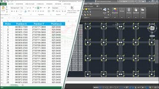
Sir Easting and Northing Coordinat Revert Tell me how to fix it Sir
good
👍
Why you couldn't use data extraction command?
We don't have vertices
Thank you for the data extraction info.
How to create a logfile path sir
Use logfilepath command
I think Data Extraction command is same more useful.
I need this excel sheet brother can you send me please
❤😂❤ thank
Serial wise hoche na dada😢
Hobe hobe. Step by step try karo
Isse easy Cad Tools K dwaara Excel Sheet Nikalta hai...
I agreed.
But with this method one can get the base knowledge of this conversion.
I enter quite too long with my 15000 points
No problem. You can export it
IT'S LONG PROSESS
Yes. It's like a jugaar. But somehow helpful
Pa g just make alignment and export file report…. Gal muk gayi… yea kya laila majnoon ki lamahdod kahani suna rahay ho…