That is absolutely beautiful. Amazing to see what remains of that railroad, more than I would have expected! You guys do a great job editing your videos, and I love every second of them. Keep it up!
I drove this line in 1974 in my new Volkswagen. The boardinghouse was standing, but leaning, and there were no historical monuments. I hiked over the top of the tunnel and thought I'd die from the exertion. Both entrances were accessible, but it wasn't possible to venture far inside. I drove the grade up the east side as far as Hancock and walked to the tunnel portal later in the 1970s. I'm 76 now and couldn't walk like you and your family did. Thanks for the memories.
Wow. Fun again. I model the Arizona Narrow Gauge Railway in ON30. This video trip is just a super inspiration of details. Thanks for sharing a trip thay many would like to do in person. The over lap of the historic photos with now really takes us back in time. I can almost feel the wind and smell the air. Well done. You're the best.
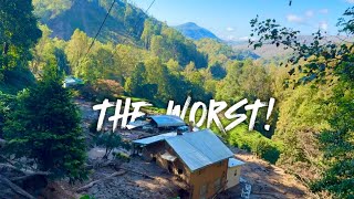
That is one of my goals: to help others experience the C&S narrow gauge "on the ground." I live on the other side of the country so I can't get there very often. Last time I was there with my family I took as much footage as I could get so these could be made.
Wow! Thank you for videoing and shaing your journey through thid amazing part of Colorado narrow gauge history....and that the kid's got to be part of it.
Very well done! Didn't see the west portal but did see the east side of the tunnel when I volunteered with the Colorado Trail Foundation in 2016 in that area. Enjoyed the great scenery. Hard to imagine all the back breaking work that went into building that RR line, only to be abandoned some 30 years later.
Excellent video. I drove up this grade back in 2020 in my F250. Only made it as far as the top of the Sherrod loop, because the trail was closed passed there to vehicles. Hiked the mile along the Palisade to get to the West Portal. Really incredible place to see in person.
You might want to take your camera up to Baldwin, which is NW of Gunnison where there was (at least in the 90's when I was last there) some preliminary rock work done in anticipation of the DSP&P following that route "over the next hill". They never finished it but stopped at the coal mines up there. Baldwin had bituminous coal whereas the "Big Mine" at Crested Butte was anthracite coal and much cleaner burning for steam engine purposes. The cave-in at Alpine Tunnel in 1910 put the kibash on further activity of the DSP&P in the Gunnison area of course.
I would love that. It is on my list of things to do sometime. Unfortunately, I'm pretty far from Colorado. I've seen some incredible photos of the rock wall near Baldwin. It would be stunning to see it in person-it looks massive.
Another great video of West Alpine Tunnel approach. I see several rock slides on the roadway, and I assume that the road is blocked to vehicle travel nowadays? Was blocked on a couple of occasions in the past when I ventured up there too.
Yes, it's blocked just above Sherrod Curve. There are plans in the works to fix the avalanche damage at the Palisades, but it's still a year or so away. There are plans to make the west portal accessible via dirt bikes in the near future and to vehicles that can go over Williams Pass.
Nice video. Cool that you pin pointed spots along the line for folks to make sense of where things are. Please stop with the music and ad more comitary of history at each spot. Music is terrible. You still rock..
I wish they would leave the access closed where it is. Much more peaceful of an experience without the cars up at the top. Get out and walk people. 👍👍👍
True. This is the weird challenge of historical preservation: If you keep a site less available, then you keep it more protected, but then with less visibility there is less interest and therefore less commitment to support it financially with donations etc. If you make it more 'visitable' then you have the challenge that it loses its peacefulness and is more 'walked-over', but more people are likely to be invested in its preservation. I don't know the complete right answer, but I'm inclined toward making the Alpine Tunnel complex more accessible.


![Natanael Cano - Amor Eterno [Official Video]](http://i.ytimg.com/vi/EO4prCs6WpM/mqdefault.jpg)

That is absolutely beautiful. Amazing to see what remains of that railroad, more than I would have expected! You guys do a great job editing your videos, and I love every second of them. Keep it up!
So glad you enjoy them!
I drove this line in 1974 in my new Volkswagen. The boardinghouse was standing, but leaning, and there were no historical monuments. I hiked over the top of the tunnel and thought I'd die from the exertion. Both entrances were accessible, but it wasn't possible to venture far inside. I drove the grade up the east side as far as Hancock and walked to the tunnel portal later in the 1970s. I'm 76 now and couldn't walk like you and your family did. Thanks for the memories.
Wow. Fun again. I model the Arizona Narrow Gauge Railway in ON30. This video trip is just a super inspiration of details. Thanks for sharing a trip thay many would like to do in person. The over lap of the historic photos with now really takes us back in time. I can almost feel the wind and smell the air. Well done. You're the best.
That is one of my goals: to help others experience the C&S narrow gauge "on the ground." I live on the other side of the country so I can't get there very often. Last time I was there with my family I took as much footage as I could get so these could be made.
Wow! Thank you for videoing and shaing your journey through thid amazing part of Colorado narrow gauge history....and that the kid's got to be part of it.
It was a dream come true to take all my girls to both side of the Alpine Tunnel that summer.
Very well done! Didn't see the west portal but did see the east side of the tunnel when I volunteered with the Colorado Trail Foundation in 2016 in that area. Enjoyed the great scenery. Hard to imagine all the back breaking work that went into building that RR line, only to be abandoned some 30 years later.
I totally agree. It feels like a Titanic situation. Grand effort followed by quick and utter failure. It adds to the mystique in a strange way.
Excellent video. I drove up this grade back in 2020 in my F250. Only made it as far as the top of the Sherrod loop, because the trail was closed passed there to vehicles. Hiked the mile along the Palisade to get to the West Portal. Really incredible place to see in person.
The good news is that a several-year long repair job is almost done and access to the West Portal by vehicles will soon be reopened.
Wow!! Another fantastic video!
You might want to take your camera up to Baldwin, which is NW of Gunnison where there was (at least in the 90's when I was last there) some preliminary rock work done in anticipation of the DSP&P following that route "over the next hill". They never finished it but stopped at the coal mines up there. Baldwin had bituminous coal whereas the "Big Mine" at Crested Butte was anthracite coal and much cleaner burning for steam engine purposes. The cave-in at Alpine Tunnel in 1910 put the kibash on further activity of the DSP&P in the Gunnison area of course.
I would love that. It is on my list of things to do sometime. Unfortunately, I'm pretty far from Colorado. I've seen some incredible photos of the rock wall near Baldwin. It would be stunning to see it in person-it looks massive.
the big mine wasnt Anthracite. It was Bituminous! Only Anthracite (Smith-Hill Mine) and Floresta were anthracite producers.
Another great video of West Alpine Tunnel approach. I see several rock slides on the roadway, and I assume that the road is blocked to vehicle travel nowadays? Was blocked on a couple of occasions in the past when I ventured up there too.
Yes, it's blocked just above Sherrod Curve. There are plans in the works to fix the avalanche damage at the Palisades, but it's still a year or so away. There are plans to make the west portal accessible via dirt bikes in the near future and to vehicles that can go over Williams Pass.
Where is that google map available? I started making one but it looks like you got WAY farther than I did!
Hi, sorry for the late reply. You can find it in the "Links" section of the dspphs.org website.
I can't take any credit for it. Someone else made it...and I'm grateful! They did a great job.
@@searchingforthecsnarrowgau8853 thanks!
how about rebuilding thos track?
Nice video. Cool that you pin pointed spots along the line for folks to make sense of where things are. Please stop with the music and ad more comitary of history at each spot. Music is terrible. You still rock..
Glad you enjoyed the video. I am doing more videos with commentary these days, but I admit to being a music fan.
I wish they would leave the access closed where it is. Much more peaceful of an experience without the cars up at the top. Get out and walk people. 👍👍👍
True. This is the weird challenge of historical preservation: If you keep a site less available, then you keep it more protected, but then with less visibility there is less interest and therefore less commitment to support it financially with donations etc. If you make it more 'visitable' then you have the challenge that it loses its peacefulness and is more 'walked-over', but more people are likely to be invested in its preservation. I don't know the complete right answer, but I'm inclined toward making the Alpine Tunnel complex more accessible.