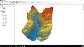
How to trape an image over a terrain surface usin ArcGis How to Edit Pdf in Word: • How to Edit PDF To see more videos visit website : www.geospatial...
thank you for your great video. just a question: After I want to add Tin to the ArcScene; but just one color comes into the arcscence. would you guide me.
I have a question. Why did you use a TIN file? You can do the same process with the raster DEM......thank you. Is there any difference if I use a DEM or a TIN?
Sir, I have latitude longitude in degrees and Height in metres Data. So I want to plot 3D spatial plot like shown in this video by using these data. Can I do that. If yes, what should I do primarily. Please do help me
You can help orient yourself within the 3D view by enabling the directional arrow navigation graphic. The three-point arrow represents the x-, y-, and z-axes of your 3D space. The larger, green arrow represents the y-direction,( civk on View.....View sitting.....Enable Directional Arrow)


![Chlöe - Shake (Feat. Jeremih) [Official Visualizer]](http://i.ytimg.com/vi/aDs_1ufpfv8/mqdefault.jpg)


1:42 min , the whole point it's around it , how can i get this UTM.tif
Where can I get the marUTM.tif file? in sasplanet how to choose?
Thank you , very useful
thank you for your great video. just a question: After I want to add Tin to the ArcScene; but just one color comes into the arcscence. would you guide me.
I have a question. Why did you use a TIN file? You can do the same process with the raster DEM......thank you. Is there any difference if I use a DEM or a TIN?
Same question here.
Same question
Same question
Your video sounds does not work compared to all other videos. Is there something I need to do to get the sound?
very great. thanks
Great working!
Sir, I have latitude longitude in degrees and Height in metres Data. So I want to plot 3D spatial plot like shown in this video by using these data. Can I do that. If yes, what should I do primarily. Please do help me
thank you very much
Nice job. Can you view x y and z axies for this project?
You can help orient yourself within the 3D view by enabling the
directional arrow navigation graphic. The three-point arrow represents
the x-, y-, and z-axes of your 3D space. The larger, green arrow
represents the y-direction,( civk on View.....View sitting.....Enable Directional Arrow)
I have question. I didnt have the ArcToolbox on menu. How to open the ArcToolbox?
go to "search" or "catalog"
nice video
ممكن سؤال اخي
sir can you explain the source of mar1UTM
same question here please
madom there in video there was using a data name"mar1 utm ,Can you explain with the data type and source.
Sat image from SASPLANET
ruclips.net/video/v_z4MgcP7BU/видео.html
@@rokiadimokrati9136 same que
thanks
1:58 that UTM FILE WHAT IS THAT?
TIN raster maybe?
its clear everything but the fancy mar1UTM how to do it
THANX
Hello please i want i programme for mines search
Nice
سلام ممكن سؤال اخي
thanks, imoprtant for me
Как скачать шип-файл
Like
Chanel bisu
thanks