Below is a link to download the QGIS Program www.qgis.org/en/site/forusers/download.html Please leave them a tip for making this software available! Below are URL's for sources of XYZTiles data ESRI Imagery -server.arcgisonline.com/arcgis/rest/services/World_Imagery/MapServer/tile/{z}/{y}/{x} Google Road - mt1.google.com/vt/1yrs=m&x={x}&y={y}&z={z} Bing Satellite - ecn.t3.tiles.virtualearth.net/tiles/a{q}.jpeg?g=1 Google Satellite Ru - www.google.ru/maps/vt?lyrs=s@189&gl=ru&x={x}&y={y}&z={z} Google Satellite - mt1.google.com/vt/lyrs=s&x={x}&y={y}&z={z} Mapzen Global Terrain - s3.amazonaws.com/elevation-tiles-prod/terrarium/{z}/{x}/{y}.png Open Street - tile.openstreetmap.org/{z}/{x}/{y}.png
Thank you so much. Following your steps I have managed to get this to work!! I ran your video stopping frequently to try each of the steps on my computer. I found your instructions methodical and clear. The software appears to be very slightly updated from when you shot this video but the sequences are all the same. BRAVO
Thank you for this video!It kinda broke my brain but I learned something about how electronic charts work! Keep up the good job on these videos. Cheers from Dundas,Ontario.
Have you evaluated sasplanet, if yes how does it compare with what you showed in video? Also curious as to whether you have used the oscilloscope to fix anything yet?
None of your XYZ Tile data links are working it seems (please check with your computer) Can you please provide new ones or let me know where I went wrong.
@@SailingAquarius Thanks for the reply! I initially just clicked on them but when nothing worked, I put them into QGIS XYZ Tiles like you said. Still inop are: Bing, ESRI, G sat RU, and NOAA. I was surprised that I couldn't solve the issue by a simple Google search. Thanks for all your detailed tech videos!!
Hi Ken, I've finally got around to downloading this program after trying to use SAS planet. I've followed everything in you're vid(I've watched it 20 times or more:) I'm getting the mobile file into a folder and I'm getting the folder into open cpn but when trying to view the chart in just getting a red box where the overlay should be. Did you have this issue when you first started out? I'm sure I've missed something?
This is great. Thanks. The satellite images work fine, and I can get great detail and zoom level in OpenCPN. But something I am doing with Google Roads or OpenStreetMap is very wrong. I cannot create any zoom levels, and all images in OpenCPN are "out of focus". I am not sure where can I go to learn that part
Thank you so much for this - it has been the only understandable video that i have found about how to do this! For some reason the urls for Bing, ESRI Imagery and Google Satellite Ru dont work! - I have maneged to find working links for Bing and ESRI but cant find a working one for Google Satellite Ru - I wonder if you might have an update on that one?
Don't know if you guys caught the news but in the Maldives today about 50 people were doing yoga at a stadium to celebrate national yoga day or something like that and a bunch of men (very unhappy men) rushed the stadium to protest. Didn't look like people were hurt but I did see some yoga matts get stabbed. And people say yoga is good for your health. Y'all left at the right time.
I think there are crazy people everywhere, even here in the US of A. Maybe it's time to head to Mars, like Elon. I will probably head back to Maldives for the 2nd annual Maldives Rally... All the best, Ken
Good day Capitan Ken- Liked the video but would ask the real time benefits of the overlays. I seen in the video the contrast between the Navionics and chart when entering the straights and you had confirmation from others the Navionics chart is best for entering. As you know, GPS can be off a little and I was taught when unsure of land site to use another methods confirming position and that is to turn on the radar and contrast that picture with your GPS. I used this method on my last boat when caught in very dense fog and could not see past the bow-It worked and the theory was put into practise and installed a great deal of confidence in a system that does work and would like to pass that onto those reading the comments. Cross referencing real time Data ;-) Can I ask you background ? Best, Allan
Real Time Benefits - When you have OpenCPN with Satellite overlays and your computer is connected to GPS (which mine is on Aquarius) - You can usually pick out the reefs under the water. This is very useful when going into areas that are not well charted, like the Maldives and the Tuamotus. I would rather use Satellite overlays than current maps available for the Maldives. You're method is good for fog, definitely turn on the radar. But, radar usually does not tell you what is 1 to 3 meters under the water, and that is where Satellite overlays are invaluable. Background Electrical Engineer.
@@SailingAquarius : Thank you for taking the time to reply Ken- Yes radar good for fog, but I was trying to articulate that GPS is not always accurate,however radar is real time and if your following a GPS chart and you may be out a little from GPS, the radar picture will confirm on a cross reference your actual position. ( I was trained in using this method on a boat course) I see you have forward looking sonar on the boat, how do you find the sonar in helping navigate in unchartered waters and has it ever made you change course ? I am in electrical myself.
I am through about 3/5 of a circumnavigation, and I have found my GPS has been within 10 feet at all times. Radar is great for real time data, and YES GPS could be off, but in my case if there was a discrepancy it was the Maps that were incorrect (Not the GPS Location). Radar is best for seeing boats without AIS, and another data point to base your decisions. Nothing is 100% correct all of the time. That's why I run 3 different sets of charts plus Satellite Overlays, and when cruising in depths less than 20 meters I turn on the Echo Pilot Forward Looking Sonar. I will use my radar if I am worried about boats without AIS coming close to Aquarius, like at night on passage.
good point Allan, radar would of confirmed which of the two entrances to the atoll was correct without having to confirm with another boater in the atoll.
Hello Ken, Thanks for the video, easy to follow and well done, great work thanks again! Im with it up to the point i try to open the captured files in CPN and they are not recognised, can anyone help? Thanks Pete
Hi Ken ,great to find out that Open CPN works on a Mac , do you use yours at the helm or only inside for planning purposes ? In one of the response you mentioned that it is connected to gps ? How ?is it build in ? I have an IPad Pro which has a build in GPS but Open CPN is not compatible with IOS yet… very interesting video again 👍
I connect my computer to the Vesper XB8000 AIS, which forwards all the NMEA data over WiFi. That way I have moving map, all the AIS data, and all the NMEA data on OpenCPN. Better than most $3000 chart plotters. I don't use the Mac in the cockpit unless I am coming into a tight spot and need additional data to navigate safely. I believe that you can get your pads working with OpenCPN as well. But we use Navionics on our Pads for maps. $50 per year for maps! that is fairly inexpensive. Ken
Thank you Ken , I have heard of the XB8000 AIS, do you also connect your hydra 2000 to it ? I am trying to find a way the get all the data received by the hydra 2K (Wind ,speed,depth ) to be send to my navigation APP, Weather 4D,and to my Raymarine autopilot using Seatalk NG…any idea ?
@johnmajewski1065 1 minute ago Fabulous Tutorial, Thank you, though it has been 1 years since you made this video I suspect not much has changed I have been searching for a How to use google earth to over lay a chart/map I do have CPN-OPEN on a Panasonic Tough Book C31 1 TB SSD with windows pro 7. Question Can I use Windows pro 7 to carry out the downloads and conversion into a chart as per your tutorial? SV Skoiern IV
If I could suggest.. please pin the links as a comment... I found that both Chrome and Firefox browser versions of the You Tube description box broke the URL links for the XYZTiles data sources
Below is a link to download the QGIS Program www.qgis.org/en/site/forusers/download.html Please leave them a tip for making this software available! Below are URL's for sources of XYZTiles data ESRI Imagery -server.arcgisonline.com/arcgis/rest/services/World_Imagery/MapServer/tile/{z}/{y}/{x} Google Road - mt1.google.com/vt/1yrs=m&x={x}&y={y}&z={z} Bing Satellite - ecn.t3.tiles.virtualearth.net/tiles/a{q}.jpeg?g=1 Google Satellite Ru - www.google.ru/maps/vt?lyrs=s@189&gl=ru&x={x}&y={y}&z={z} Google Satellite - mt1.google.com/vt/lyrs=s&x={x}&y={y}&z={z} Mapzen Global Terrain - s3.amazonaws.com/elevation-tiles-prod/terrarium/{z}/{x}/{y}.png Open Street - tile.openstreetmap.org/{z}/{x}/{y}.png


Below is a link to download the QGIS Program
www.qgis.org/en/site/forusers/download.html
Please leave them a tip for making this software available!
Below are URL's for sources of XYZTiles data
ESRI Imagery -server.arcgisonline.com/arcgis/rest/services/World_Imagery/MapServer/tile/{z}/{y}/{x}
Google Road - mt1.google.com/vt/1yrs=m&x={x}&y={y}&z={z}
Bing Satellite - ecn.t3.tiles.virtualearth.net/tiles/a{q}.jpeg?g=1
Google Satellite Ru - www.google.ru/maps/vt?lyrs=s@189&gl=ru&x={x}&y={y}&z={z}
Google Satellite - mt1.google.com/vt/lyrs=s&x={x}&y={y}&z={z}
Mapzen Global Terrain - s3.amazonaws.com/elevation-tiles-prod/terrarium/{z}/{x}/{y}.png
Open Street - tile.openstreetmap.org/{z}/{x}/{y}.png
Thank you so much. Following your steps I have managed to get this to work!! I ran your video stopping frequently to try each of the steps on my computer.
I found your instructions methodical and clear. The software appears to be very slightly updated from when you shot this video but the sequences are all the same.
BRAVO
Happy it helped 👍
Going to watch this one a few times as we setup OpenCPN. Well done guys and thanks. J&J
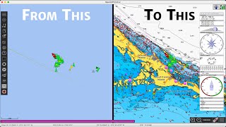
Glad that someone understands the value of Satellite overlays! I am starting to wonder why I spend so much time making these videos. All the best, Ken
Thank you for this video!It kinda broke my brain but I learned something about how electronic charts work!
Keep up the good job on these videos.
Cheers from Dundas,Ontario.
You're welcome!
Smart solution for a tricky issue. Good job! Thanx for the effort and for sharing. Kind regards
Glad you liked it!
Have you evaluated sasplanet, if yes how does it compare with what you showed in video?
Also curious as to whether you have used the oscilloscope to fix anything yet?
thanks for your great work! google satelite overlays work great! regards from austria!
Glad it helped!
None of your XYZ Tile data links are working it seems (please check with your computer) Can you please provide new ones or let me know where I went wrong.
Did you put them into the QGIS program, or just try the link on a browser?
@@SailingAquarius Thanks for the reply! I initially just clicked on them but when nothing worked, I put them into QGIS XYZ Tiles like you said. Still inop are: Bing, ESRI, G sat RU, and NOAA. I was surprised that I couldn't solve the issue by a simple Google search. Thanks for all your detailed tech videos!!
not working here either
VERY Interesting THANKS Ken
You are very welcome
Hi Ken, I've finally got around to downloading this program after trying to use SAS planet. I've followed everything in you're vid(I've watched it 20 times or more:)
I'm getting the mobile file into a folder and I'm getting the folder into open cpn but when trying to view the chart in just getting a red box where the overlay should be. Did you have this issue when you first started out? I'm sure I've missed something?
Me too. Did you ever figure this out?
@@andypag1071 no, I think Ken has missed something in his vid?
Woah…Really aimed for Savvy Sailors\Navigators…But this Old Fart happy someone can do it👍 Continue to Stay Safe & Enjoy😎
Hope that this helps a few sailors... Pass this video on to others!
This is great. Thanks. The satellite images work fine, and I can get great detail and zoom level in OpenCPN. But something I am doing with Google Roads or OpenStreetMap is very wrong. I cannot create any zoom levels, and all images in OpenCPN are "out of focus". I am not sure where can I go to learn that part
Thank you so much for this - it has been the only understandable video that i have found about how to do this! For some reason the urls for Bing, ESRI Imagery and Google Satellite Ru dont work! - I have maneged to find working links for Bing and ESRI but cant find a working one for Google Satellite Ru - I wonder if you might have an update on that one?
Thanks for sharing
Ty keep it up Captain Ken
Thanks
Don't know if you guys caught the news but in the Maldives today about 50 people were doing yoga at a stadium to celebrate national yoga day or something like that and a bunch of men (very unhappy men) rushed the stadium to protest. Didn't look like people were hurt but I did see some yoga matts get stabbed. And people say yoga is good for your health. Y'all left at the right time.
I think there are crazy people everywhere, even here in the US of A. Maybe it's time to head to Mars, like Elon. I will probably head back to Maldives for the 2nd annual Maldives Rally... All the best, Ken
Good day Capitan Ken- Liked the video but would ask the real time benefits of the overlays. I seen in the video the contrast between the Navionics and chart when entering the straights and you had confirmation from others the Navionics chart is best for entering. As you know, GPS can be off a little and I was taught when unsure of land site to use another methods confirming position and that is to turn on the radar and contrast that picture with your GPS. I used this method on my last boat when caught in very dense fog and could not see past the bow-It worked and the theory was put into practise and installed a great deal of confidence in a system that does work and would like to pass that onto those reading the comments. Cross referencing real time Data ;-)
Can I ask you background ?
Best, Allan
Real Time Benefits - When you have OpenCPN with Satellite overlays and your computer is connected to GPS (which mine is on Aquarius) - You can usually pick out the reefs under the water. This is very useful when going into areas that are not well charted, like the Maldives and the Tuamotus. I would rather use Satellite overlays than current maps available for the Maldives. You're method is good for fog, definitely turn on the radar. But, radar usually does not tell you what is 1 to 3 meters under the water, and that is where Satellite overlays are invaluable. Background Electrical Engineer.
@@SailingAquarius : Thank you for taking the time to reply Ken- Yes radar good for fog, but I was trying to articulate that GPS is not always accurate,however radar is real time and if your following a GPS chart and you may be out a little from GPS, the radar picture will confirm on a cross reference your actual position. ( I was trained in using this method on a boat course) I see you have forward looking sonar on the boat, how do you find the sonar in helping navigate in unchartered waters and has it ever made you change course ?
I am in electrical myself.
I am through about 3/5 of a circumnavigation, and I have found my GPS has been within 10 feet at all times. Radar is great for real time data, and YES GPS could be off, but in my case if there was a discrepancy it was the Maps that were incorrect (Not the GPS Location). Radar is best for seeing boats without AIS, and another data point to base your decisions. Nothing is 100% correct all of the time. That's why I run 3 different sets of charts plus Satellite Overlays, and when cruising in depths less than 20 meters I turn on the Echo Pilot Forward Looking Sonar. I will use my radar if I am worried about boats without AIS coming close to Aquarius, like at night on passage.
good point Allan, radar would of confirmed which of the two entrances to the atoll was correct without having to confirm with another boater in the atoll.
Hello Ken, Thanks for the video, easy to follow and well done, great work thanks again! Im with it up to the point i try to open the captured files in CPN and they are not recognised, can anyone help?
Thanks Pete
I am not sure why it's not working for you. I will have to do this again...
Hi Ken ,great to find out that Open CPN works on a Mac , do you use yours at the helm or only inside for planning purposes ? In one of the response you mentioned that it is connected to gps ? How ?is it build in ? I have an IPad Pro which has a build in GPS but Open CPN is not compatible with IOS yet… very interesting video again 👍
I connect my computer to the Vesper XB8000 AIS, which forwards all the NMEA data over WiFi. That way I have moving map, all the AIS data, and all the NMEA data on OpenCPN. Better than most $3000 chart plotters. I don't use the Mac in the cockpit unless I am coming into a tight spot and need additional data to navigate safely. I believe that you can get your pads working with OpenCPN as well. But we use Navionics on our Pads for maps. $50 per year for maps! that is fairly inexpensive.
Ken
Thank you Ken , I have heard of the XB8000 AIS, do you also connect your hydra 2000 to it ? I am trying to find a way the get all the data received by the hydra 2K (Wind ,speed,depth ) to be send to my navigation APP, Weather 4D,and to my Raymarine autopilot using Seatalk NG…any idea ?
I also use CM93 on OpenCPM, but have never encountered any discrepancies between the real world and the map here in Europe. What is your experience?
I have not been to the EU with Aquarius, but I am sure that there are places that are not well charted. Google overlays are invaluable!
@@SailingAquarius Will check.Thank u for doing this...
@johnmajewski1065
1 minute ago
Fabulous Tutorial, Thank you, though it has been 1 years since you made this video I suspect not much has changed I have been searching for a How to use google earth to over lay a chart/map
I do have CPN-OPEN on a Panasonic Tough Book C31 1 TB SSD with windows pro 7. Question Can I use Windows pro 7 to carry out the downloads and conversion into a chart as per your tutorial?
SV Skoiern IV
Yes, I believe so.
well done sir
Thanks!
Very interesting… difficult to follow at times, but one just have to view it multiple times. Perhaps more detailed explanations?
If I could suggest.. please pin the links as a comment... I found that both Chrome and Firefox browser versions of the You Tube description box broke the URL links for the XYZTiles data sources
Below is a link to download the QGIS Program
www.qgis.org/en/site/forusers/download.html
Please leave them a tip for making this software available!
Below are URL's for sources of XYZTiles data
ESRI Imagery -server.arcgisonline.com/arcgis/rest/services/World_Imagery/MapServer/tile/{z}/{y}/{x}
Google Road - mt1.google.com/vt/1yrs=m&x={x}&y={y}&z={z}
Bing Satellite - ecn.t3.tiles.virtualearth.net/tiles/a{q}.jpeg?g=1
Google Satellite Ru - www.google.ru/maps/vt?lyrs=s@189&gl=ru&x={x}&y={y}&z={z}
Google Satellite - mt1.google.com/vt/lyrs=s&x={x}&y={y}&z={z}
Mapzen Global Terrain - s3.amazonaws.com/elevation-tiles-prod/terrarium/{z}/{x}/{y}.png
Open Street - tile.openstreetmap.org/{z}/{x}/{y}.png
Thanks Ken! Definitely not interested in doing things that bump in the night…
You bet.. Yes, bump in the night is not a good thing on a sailboat!
I just take screen shots from google earth of what I need.
Whatever floats your boat ;) :)