
- Видео 58
- Просмотров 507 206
Geo Guru
Индия
Добавлен 17 мар 2020
Creating Groundwater Level Maps with QGIS: IDW vs. Thin Plate Spline | Spatial Interpolation
Spatial interpolation is a widely employed method in hydrology and Geology to generate groundwater level maps. It serves the purpose of estimating groundwater levels in areas lacking direct data, utilizing information from nearby wells. Various spatial interpolation techniques are at your disposal. In this video, we demonstrate the creation of groundwater level maps using two distinct methods: Inverse Distance Weighting (IDW) and Thin Plate Spline within the QGIS software.
Additionally, we provide a tutorial on how to install the SAGA plugin in QGIS 3.0 or newer. Watch the tutorial here: [ruclips.net/video/iTr7fQucqUA/видео.htmlsi=qB0dtFJ13HIU9CSU]
Additionally, we provide a tutorial on how to install the SAGA plugin in QGIS 3.0 or newer. Watch the tutorial here: [ruclips.net/video/iTr7fQucqUA/видео.htmlsi=qB0dtFJ13HIU9CSU]
Просмотров: 851
Видео

Installing SAGA GIS in QGIS 3.0 or above
Просмотров 22 тыс.9 месяцев назад
The latest version of QGIS (3.0 or higher) does not include the built-in SAGA GIS tool, which can make it challenging to perform various advanced raster and vector processing tasks. In this tutorial, you will learn how to externally install the SAGA GIS tool in QGIS through a straightforward process.

Calculate Cut & Fill volume in QGIS
Просмотров 2,8 тыс.9 месяцев назад
In this comprehensive QGIS tutorial, we'll guide you through the process of calculating volume for filling and cutting purposes using a Digital Elevation Model (DEM). The tutorial is conducted at mining site in Germany (50.9014 N, 6.5183 E). This exercise can seed in many engineering domains like Civil and construction Engineering, Geology, Environment etc.

Download Rainfall data using Google Earth Engine
Просмотров 2,8 тыс.9 месяцев назад
In this tutorial, we will guide you through the process of downloading Rainfall data of any area around the world using this simple script in Google Earth Engine. link for the script to download the Rainfall data using Javascript in GEE github.com/sukantjain/Google-Earth-Engine/blob/main/JavaScript/RainfallData_usingGEE.js Link to download Rainfall data using Python in GEE github.com/sukantjain...

Multiple Criteria Overlay Analysis Using QGIS (Vector Data)
Просмотров 8 тыс.10 месяцев назад
Welcome to our RUclips tutorial on "Multiple Criteria Overlay Analysis Using QGIS." In this tutorial, we will guide you through the process of selecting optimal areas for building new parking facilities in the Westminster borough of London. We will leverage the power of QGIS and geoprocessing techniques to make data-driven decisions that can help reduce bicycle thefts in the area. In this tutor...

Crime Mapping & Analysis in QGIS
Просмотров 2 тыс.10 месяцев назад
Welcome to our QGIS tutorial on identifying crime hotspots and mapping crime statistics. In this video, we will learn spatial analysis to understand how crime data can be effectively visualized and analyzed. We'll explore various statistical and Geographic Information Systems (GIS) techniques to uncover spatial and temporal patterns within the dataset. 🌐 Data Source: We will be using three dist...

Crime Hotspot Identification and Mapping using QGIS
Просмотров 3,2 тыс.10 месяцев назад
Welcome to our QGIS tutorial, where we will perform spatial analysis to identify crime hotspots and map temporal changes. In this video, we will explore advanced techniques for working with dense point datasets, focusing on crime incidents. Our goal is to uncover insights and visualize how these hotspots evolve month-to-month. 🔍 Data Source: We'll be using data from the "London Individual crime...
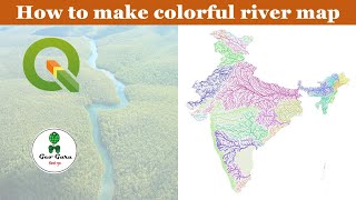
Creating a Stunning and Informative River Map with QGIS (No Python or ArcGIS Needed)
Просмотров 3,9 тыс.Год назад
Welcome to our tutorial on crafting a captivating and educational river map of India using QGIS alone, without the need for Python or ArcGIS. We'll demonstrate how to harness Hydroshed basin and river data to extract India's intricate river system and then beautifully color-code the rivers and their tributaries according to their basins. 🌊 What You'll Discover: Accessing and downloading Hydrosh...

Creating Flow Duration Curve (FDC) Curves Using Discharge Data | Tutorial
Просмотров 3,7 тыс.Год назад
Welcome to this comprehensive tutorial on creating FDC (Flow Duration Curve) curves using discharge data. In this video, we will guide you through the process of generating FDC curves, a fundamental tool in hydrological analysis for understanding and assessing river flow characteristics. FDC curves provide crucial information about the distribution of river flows over time. By plotting the perc...
Creating IDF Curves for Different Durations and AEPs (Return Period) | Tutorial
Просмотров 9 тыс.Год назад
In this tutorial, we will guide you through the process of creating IDF (Intensity-Duration-Frequency) curves for different durations and AEPs (Annual Exceedance Probabilities). Using the TRMM 3H rainfall data, we will demonstrate how to generate these curves, which are crucial for hydrological and infrastructure design. IDF curves provide essential information for assessing rainfall intensity ...
Drought Mapping with VCI in Google Earth Engine: A Step-by-Step Tutorial
Просмотров 7 тыс.Год назад
In this tutorial, you will learn how to use the Vegetation Condition Index (VCI) in Google Earth Engine to create drought maps. Droughts can have devastating effects on agriculture, water resources, and the environment, and mapping their extent is crucial for effective management and response. We will guide you through the process of importing and visualizing satellite imagery, calculating VCI,...
Calculating Maximum Consecutive Dry Days using Google Earth Engine Iterate Function
Просмотров 846Год назад
In this tutorial video, we will show you how to use the iterate function in Google Earth Engine to calculate the number of maximum consecutive dry days with no rainfall. We will also try to explain the algorithm behind this calculation and provide a simple illustration using a spreadsheet file. You can apply this function and algorithm in other climate related datasets like temperature etc. for...
Using ChatGPT for Geospatial Analysis with Python
Просмотров 1,1 тыс.Год назад
In this tutorial, we will explore how we can use the powerful language model ChatGPT to extract data from the web and convert it into a pandas dataframe. We'll then use the Geopandas library to geocode the data and finally plot it using the folium library. Join us as we take a deep dive into using ChatGPT for Geospatial analysis in Python.
Generating Scatter Plots in Google Earth Engine: Elevation and Temperature Analysis
Просмотров 1,4 тыс.Год назад
In this tutorial, we will show you how to use Google Earth Engine to generate scatter plots using elevation and temperature data. We will also demonstrate how to display a regression line over the scatter plot, making it easier to analyze the data and identify patterns. Whether you're a GIS professional or just getting started with Earth Engine, this tutorial is a great resource for understandi...
Estimating Soil loss in Google Earth Engine | RUSLE Modelling
Просмотров 11 тыс.Год назад
The Universal Soil Loss Equation (USLE) is a widely used mathematical model that describes soil erosion processes. Now, don't need to download numerous of Geospatial data for RUSLE modelling. Just go to your GEE code editor and use the script to estimate soil loss in any part of the world Link for the script: - github.com/sukantjain/Google-Earth-Engine/blob/main/JavaScript/RUSLE in GEE.js code....
Download IMD gridded data into CSV without any software | IMDLIB | Python
Просмотров 16 тыс.Год назад
Download IMD gridded data into CSV without any software | IMDLIB | Python
Supervised classification using Google Earth Engine || Landcover classification
Просмотров 4,2 тыс.2 года назад
Supervised classification using Google Earth Engine || Landcover classification
Calculating area in Google Earth Engine || Part-3/3
Просмотров 1,3 тыс.2 года назад
Calculating area in Google Earth Engine || Part-3/3
Calculating area in Google Earth Engine || Part-2/3
Просмотров 1,8 тыс.2 года назад
Calculating area in Google Earth Engine || Part-2/3
Calculating area in Google Earth Engine || Part-1/3
Просмотров 6 тыс.2 года назад
Calculating area in Google Earth Engine || Part-1/3
Animating Time series data in QGIS || Time Controller
Просмотров 6 тыс.2 года назад
Animating Time series data in QGIS || Time Controller
Viewshed analysis in QGIS 3 | visibility analysis | part-2
Просмотров 6 тыс.2 года назад
Viewshed analysis in QGIS 3 | visibility analysis | part-2
Viewshed analysis in QGIS 3 | visibility analysis | part-1
Просмотров 14 тыс.2 года назад
Viewshed analysis in QGIS 3 | visibility analysis | part-1
Web-Based tool to Delineate Watershed & Drainage Network
Просмотров 4,6 тыс.2 года назад
Web-Based tool to Delineate Watershed & Drainage Network
Google Earth Engine based Rainfall Runoff Model workshop at Pravaaha 2022 | IIT Roorkee
Просмотров 10 тыс.2 года назад
Google Earth Engine based Rainfall Runoff Model workshop at Pravaaha 2022 | IIT Roorkee
Geo Coding addresses using Google Earth Pro
Просмотров 9662 года назад
Geo Coding addresses using Google Earth Pro
Import CSV, SHP, Tiff files in Google Earth Pro
Просмотров 4,5 тыс.2 года назад
Import CSV, SHP, Tiff files in Google Earth Pro
thank you so much :)
Insert me map ka option na diya ho to kya kre
thanks this helped so much!
After Delineation,how do I represent the Delineated area in terms of elevation,rainfall and land use?
Thank you
thank you sir, i want to download monthly i dont want the daily rainfall is it possible
from where you take data or shpefiles use in this video
Nice Explanation
How to download half year data from colab
Thank you!!!
What is the point of this plugin?
Can I get rainfall, temperature, humidity and other climatic parameters till date? Means may 2024?
Hi, how can i mencion u in a work that im doing? u have any web page or something
hello sir. thanks for solving this issue of getting it in csv. but sir, it is making the downloads for a particular point. What should i do if i want the daily tmax and tmin data 2001-2021 for an entire polygon (study area)? what will be the code for that?
Sir downloaded rainfall data is in mm or cm ?
I want to download for Agra region how do I download
funciona perfecto! muchas gracias por compartirlo
sure the 900m²/pixel is constant over the area? 🤔
Sir, can you please provide ethe script to export these final output to drive?
please provide code sir
Why do we add previous to the updated at the return ?didn't understand that part
thank you,you saved my homework😇
Thanks a lot 🙏 Amazing 🎉
Thank u
Thank you. I used your code to download temp data.
One question: what does the option "signature" on the check box do exactly?
remove the stupid logo away from the centre of video thanks
Thank you so much. It worked
Please.. upload the code you used in the comments !!
Hello sir, How to find humidity data ?
Thanks a lot!! THIS is what I was looking for. You can easily make any map from this. Subscribed, liked and saved!!
Very nice. How can we further convert those extracted water bodies to vector polygon layer ?
Impressive! ❤
hii, I have tried your code but error is showing that "ImageCollection.load: ImageCollection asset 'imageCollection' not found (does not exist or caller does not have access)." please explain
Thanks so much! You saved our degree hahah
I have followed your video but It is showing memory error when I run viewshed option.
Sir, can you provide the link to the paper using which you have generated those classes in K factor and P factor?
wena hermano mio toma un like 👌
How to do the region wise data map in a district
which dataset is this?
Thanks!!!
"Great job! Your tutorial is fantastic and really helpful. Could you please provide me with the JavaScript code for the project? ''
llevaba dos días intentando lograr instalar SAGA en Qgis para mi proyecto final. Eres una gran persona Geo Guru. Agradecido por tu aporte.
I have tried this for the Mac version of QGIS and I am not able to get it to work.
Very useful, thanks so much!!
Thanks !
I followed the same steps but when I saved it the title is coming in the centre but I saved it in the bottom center. What should I do?
Geo Guru - this was an excellent presentation - thank you for sharing.
It did not work for me, the saga menu still does not show up in my toolbox bar. I got this error after changing the folder destination: An error has occurred while executing Python code: RuntimeError: wrapped C/C++ object of type ZonalStatisticsMultibandAlgorithm has been deleted
Did you solve it? I have the same issue...
you are a god