
- –Т–Є–і–µ–Њ 44
- –Я—А–Њ—Б–Љ–Њ—В—А–Њ–≤ 44 796
Learn Geography GIS RS with AI
–Ф–Њ–±–∞–≤–ї–µ–љ 23 –і–µ–Ї 2023
Welcome to Learn Geography GEE/GIS/RS with AI! рЯМНрЯМРрЯ§Ц
рЯ§Ц Integrating AI for Enhanced Understanding:
Witness the synergy of Geography with Artificial Intelligence! My content goes beyond the basics, exploring how AI augments geographic analysis, providing new perspectives and insights into the intricate tapestry of landscapes, urban environments, and ecosystems.
рЯУЪ What to Expect:
рЯМН In-depth Tutorials: Step-by-step guides on GIS and RS applications.
рЯ§Ц AI and Geography Fusion: Exploring the intersection of Artificial Intelligence and Geographic Sciences.
рЯМР Case Studies: Real-world examples showcasing the power of spatial analysis.
рЯМН Interactive Learning: Engage with quizzes, challenges, and hands-on exercises.
рЯС£ Let's Explore, Learn, and Innovate Together!
Hit the subscribe button, turn on notifications, and join us as we unravel the interconnected layers of our dynamic world.
#LearnGeography #GIS #RemoteSensing #ArtificialIntelligence #GeospatialEducation
Soil pH Map Using Google Earth Engine And ArcMap Soil Analysis Remote Sensing Comprehensive Tutorial
My name is Ali, and I'll be guiding you through the entire process, step by step.
In this video, we'll start by loading the soil pH data into Google Earth Engine, where we will process and analyze various datasets to understand the soil acidity and alkalinity across different regions. Then, we will shift our focus to ArcMap, where we'll refine our maps, add additional layers, and prepare them for professional presentation. рЯУЪ This comprehensive guide is perfect for students, researchers, and professionals interested in environmental science, geography, and remote sensing. Whether you're a beginner or an experienced user, this tutorial will equip you with the knowledge to create your own soi...
In this video, we'll start by loading the soil pH data into Google Earth Engine, where we will process and analyze various datasets to understand the soil acidity and alkalinity across different regions. Then, we will shift our focus to ArcMap, where we'll refine our maps, add additional layers, and prepare them for professional presentation. рЯУЪ This comprehensive guide is perfect for students, researchers, and professionals interested in environmental science, geography, and remote sensing. Whether you're a beginner or an experienced user, this tutorial will equip you with the knowledge to create your own soi...
–Я—А–Њ—Б–Љ–Њ—В—А–Њ–≤: 1 875
–Т–Є–і–µ–Њ


Vegetation Drought Assessment Using SPI (Standardized Precipitation Index) using Google Earth Engine
–Я—А–Њ—Б–Љ–Њ—В—А–Њ–≤ 2,2 —В—Л—Б.9 –Љ–µ—Б—П—Ж–µ–≤ –љ–∞–Ј–∞–і
drive.google.com/file/d/1vTzIuNrT8veJSWlaAqQDGZkukypscVOd/view?usp=sharing The code first loads a specific area named "lowerpunjab" from a user's collection. This area is likely a region of interest for further analysis. Then, it loads precipitation data from a collection named "UCSB-CHG/CHIRPS/PENTAD" for the period 2017-2023. It selects the "precipitation" band, filters the data for the desir...
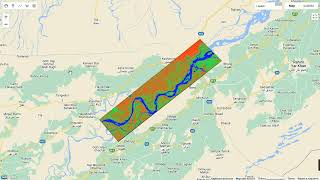
Tracking 30 Year Of Water Change Detection & River Course Change Analysis using Google Earth Engine
–Я—А–Њ—Б–Љ–Њ—В—А–Њ–≤ 3,1 —В—Л—Б.9 –Љ–µ—Б—П—Ж–µ–≤ –љ–∞–Ј–∞–і
"Tracking 30 Years of Water Change Detection & River Course Change Analysis using Google Earth Engine" Link: drive.google.com/file/d/1a4G-jAKpj2sxjavhxTWlmiApBUQ8AH7X/view?usp=drive_link Welcome to my RUclips channel! In this video, I'll be taking you on a fascinating journey through three decades of environmental change, focusing on water bodies and the course of rivers. Using the powerful too...

Deforestation Mapping GIS & RS Tutorial Tracking 30 Year Forest Loss in Pakistan Google Earth Engine
–Я—А–Њ—Б–Љ–Њ—В—А–Њ–≤ 8189 –Љ–µ—Б—П—Ж–µ–≤ –љ–∞–Ј–∞–і
In this video, we'll embark on a journey to track forest loss in Pakistan over the past 30 years! Buckle up as we dive into the fascinating world of Geospatial Information Systems (GIS) and Remote Sensing (RS). We'll leverage the power of Google Earth Engine, a free and powerful platform, to analyze satellite imagery and uncover deforestation trends. Here's what you can expect: Learn the basics...
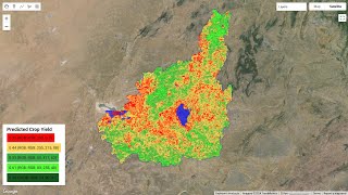
Crop Yield Prediction Map, Using Linear Regression Model Using Satellite Data on Google Earth Engine
–Я—А–Њ—Б–Љ–Њ—В—А–Њ–≤ 5 —В—Л—Б.10 –Љ–µ—Б—П—Ж–µ–≤ –љ–∞–Ј–∞–і
Welcome to my RUclips channel, "Learn Geography GIS RS with AI"! Today, I'm excited to demonstrate how you can create a crop yield prediction map using a linear regression model, leveraging satellite data on the Google Earth Engine platform. Throughout this tutorial, I'll guide you through the process of handling MODIS Surface Reflectance Original (SR ORG 6974) data, including managing its coor...

High Resolution Land Cover Land Use Classification S2 for your study Area Using Google earth Engine
–Я—А–Њ—Б–Љ–Њ—В—А–Њ–≤ 1,2 —В—Л—Б.10 –Љ–µ—Б—П—Ж–µ–≤ –љ–∞–Ј–∞–і
In this video, we'll walk through classifying Land Cover Land Use (LULC) on Sentinel-2 10 meter high resolution satellite imagery using Google Earth Engine (GEE). GEE is a powerful platform for Earth observation analysis. We'll start by loading your Area of Interest (AOI), which is the specific region you want to analyze. This could be a city, a forest, or any area you're interested in. Next, w...

OBIA supervised object based image classification using google earth engine
–Я—А–Њ—Б–Љ–Њ—В—А–Њ–≤ 80110 –Љ–µ—Б—П—Ж–µ–≤ –љ–∞–Ј–∞–і
Welcome to my RUclips channel! Today, I'm excited to show you how to perform object-based image classification using Google Earth Engine. To get started, I defined my area of interest (AOI) in Lahore, Pakistan. This AOI serves as the focal point for our analysis, allowing us to zoom in on a specific geographic area and extract relevant imagery. Next, I filtered the Sentinel-2 image collection b...

Lake and River Water Quality : NDCI and NDWI Analysis with Google Earth Engine (Water Analysis GIS).
–Я—А–Њ—Б–Љ–Њ—В—А–Њ–≤ 73810 –Љ–µ—Б—П—Ж–µ–≤ –љ–∞–Ј–∞–і
рЯМК Explained How To Compute NDWI and NDCI To Exploring Water Bodies: Remote Sensing with Sentinel-2 Imagery рЯМК Join us on a fascinating journey as we utilize Sentinel-2 satellite imagery to explore water bodies, focusing on Manchar Lake as our prime example. In this tutorial, we delve into the intricate process of image visualization and analysis, uncovering the secrets hidden within the data. рЯФН ...

Heat Map LST Generation Using Google Earth Engine with Layout Designing in ArcMAP 10.8 (Lahore LST).
–Я—А–Њ—Б–Љ–Њ—В—А–Њ–≤ 1,1 —В—Л—Б.10 –Љ–µ—Б—П—Ж–µ–≤ –љ–∞–Ј–∞–і
Welcome to Learn Geography GIS RS GEE With AI! In this video, I'll guide you through the process of generating a Heat Map or Land Surface Temperature (LST) using Google Earth Engine. First, I'll define our area of interest, focusing on Lahore, Pakistan, utilizing Google Earth Engine's powerful geospatial analysis capabilities. Then, I'll set Lahore as the center of our map to ensure accurate vi...
Calculate VHI,VCI,TCI,SMI,PDSI,SPI vegetation drought monitoring using Google Earth Engine (GEE).
–Я—А–Њ—Б–Љ–Њ—В—А–Њ–≤ 3,3 —В—Л—Б.10 –Љ–µ—Б—П—Ж–µ–≤ –љ–∞–Ј–∞–і
In this video, we delve into the fascinating world of vegetation drought monitoring using Google Earth Engine (GEE). We explore the calculation of essential indices such as the Vegetation Health Index (VHI), Vegetation Condition Index (VCI), Temperature Condition Index (TCI), Soil Moisture Index (SMI), Palmer Drought Severity Index (PDSI), and Standardized Precipitation Index (SPI). Each of the...
Monitoring Vegetation Health & Stress with Vegetation Condition Index (VCI) Using Google Earth Engin
–Я—А–Њ—Б–Љ–Њ—В—А–Њ–≤ 1,1 —В—Л—Б.11 –Љ–µ—Б—П—Ж–µ–≤ –љ–∞–Ј–∞–і
Understanding Vegetation Health: Mapping Vegetation Condition Index (VCI) in Lahore & Chichawatni, Pakistan: Variable Initialization: HandsomePakistani: An object containing visualization parameters for the VCI (Vegetation Condition Index) layer, including bands, opacity, and palette. LearnGeographyGISrsWithAI: A variable storing a FeatureCollection representing the area of interest (AOI) shape...
Urban Heat Island (UHI) Map using Google Earth Engine and ArcMap Calculate Urban Heat Index and LST
–Я—А–Њ—Б–Љ–Њ—В—А–Њ–≤ 4,2 —В—Л—Б.11 –Љ–µ—Б—П—Ж–µ–≤ –љ–∞–Ј–∞–і
NDVI Empowered UHI Mapping: Combining Vegetation and Land Surface Temperature, Karachi's Urban Heat Islands: From LST to UHI Index with GEE and ArcMap(Landsat 8 for Urban Heat Island Analysis: Karachi in Focus) Let's Start Video Description:Learn how to map Urban Heat Islands (UHIs) with Google Earth Engine (GEE) and explore the case of Karachi, Pakistan!This video takes you through the process...
Heat Waves Impact Using Modis To Analyze Vegetation Health with LST Using Google Earth Engine Lahore
–Я—А–Њ—Б–Љ–Њ—В—А–Њ–≤ 72011 –Љ–µ—Б—П—Ж–µ–≤ –љ–∞–Ј–∞–і
Heat Waves in Pakistan: Unmasking Vegetation & Temperature Secrets with GEE! Are you concerned about the impact of heat waves on Pakistan's environment? Join me,My Name Is Ali, as we delve into the fascinating world of Earth Engine (GEE) to analyze this critical issue! In this video, we'll embark on a data-driven journey to: Uncover vegetation health trends using MODIS satellite imagery and NDV...
Population Map Google Earth Engine i.e Lahore and for ArcMap: Visualizing Population Dynamics futur
–Я—А–Њ—Б–Љ–Њ—В—А–Њ–≤ 21211 –Љ–µ—Б—П—Ж–µ–≤ –љ–∞–Ј–∞–і
Lahore Population: From Past to Future with GEE and AI :
Urban and Non Urban Classification Using GEE and ArcGIS to get Residential Area and Zonal Statistics
–Я—А–Њ—Б–Љ–Њ—В—А–Њ–≤ 82411 –Љ–µ—Б—П—Ж–µ–≤ –љ–∞–Ј–∞–і
Urban and Non-Urban Classification with GEE: Residential Area Extraction and Zonal Statistics In this project, I focused on delineating urban and non-urban areas within the scope of Pakistan (Lahore). Initially, I defined my area of interest (AOI) as Lahore Pakistan, which served as the spatial boundary for subsequent analyses. Leveraging the capabilities of Google Earth Engine (GEE). Using sat...
Predictive Modeling of Flood Risks in the Philippines Manila Bay video using GEE
–Я—А–Њ—Б–Љ–Њ—В—А–Њ–≤ 95–У–Њ–і –љ–∞–Ј–∞–і
Predictive Modeling of Flood Risks in the Philippines Manila Bay video using GEE
Load OSM data in GEE and Get Buildings Statistics polygons number Using Google Earth Engine : Lahore
–Я—А–Њ—Б–Љ–Њ—В—А–Њ–≤ 557–У–Њ–і –љ–∞–Ј–∞–і
Load OSM data in GEE and Get Buildings Statistics polygons number Using Google Earth Engine : Lahore
Download Buildings Polygons for ArcGis and Open street map OSM data for armap i.e Lahore Pakistan RS
–Я—А–Њ—Б–Љ–Њ—В—А–Њ–≤ 340–У–Њ–і –љ–∞–Ј–∞–і
Download Buildings Polygons for ArcGis and Open street map OSM data for armap i.e Lahore Pakistan RS
Calculate LST Time Series Multiple Areas using Google Earth Engine : Pakistan's Provinces LST.
–Я—А–Њ—Б–Љ–Њ—В—А–Њ–≤ 866–У–Њ–і –љ–∞–Ј–∞–і
Calculate LST Time Series Multiple Areas using Google Earth Engine : Pakistan's Provinces LST.
Automated LULC CROP Classification Sentinel Data USING GEE : Crop Classification Google Earth Engine
–Я—А–Њ—Б–Љ–Њ—В—А–Њ–≤ 1,4 —В—Л—Б.–У–Њ–і –љ–∞–Ј–∞–і
Automated LULC CROP Classification Sentinel Data USING GEE : Crop Classification Google Earth Engine
Forest TREE Cover % percentage with GIS and Remote Sensing & GEE, Learn Geography GIS RS with AI
–Я—А–Њ—Б–Љ–Њ—В—А–Њ–≤ 435–У–Њ–і –љ–∞–Ј–∞–і
Forest TREE Cover % percentage with GIS and Remote Sensing & GEE, Learn Geography GIS RS with AI
Philippines Colorful Digital Elevation DEM Model Using GEE and Processing in ArcMap 10.8
–Я—А–Њ—Б–Љ–Њ—В—А–Њ–≤ 185–У–Њ–і –љ–∞–Ј–∞–і
Philippines Colorful Digital Elevation DEM Model Using GEE and Processing in ArcMap 10.8
Mapping Urban Development: Analyzing Building Footprints Using Google Earth Engine
–Я—А–Њ—Б–Љ–Њ—В—А–Њ–≤ 260–У–Њ–і –љ–∞–Ј–∞–і
Mapping Urban Development: Analyzing Building Footprints Using Google Earth Engine
Creating Animated NDVI Thumbnails with Google Earth Engine Tutorial
–Я—А–Њ—Б–Љ–Њ—В—А–Њ–≤ 269–У–Њ–і –љ–∞–Ј–∞–і
Creating Animated NDVI Thumbnails with Google Earth Engine Tutorial
Create and Download a Shapefile for Any Location Worldwide
–Я—А–Њ—Б–Љ–Њ—В—А–Њ–≤ 70–У–Њ–і –љ–∞–Ј–∞–і
Create and Download a Shapefile for Any Location Worldwide
Calculate the average Land Surface Temperature LST for each month Using GEE and ArcGIS Big Area LST.
–Я—А–Њ—Б–Љ–Њ—В—А–Њ–≤ 410–У–Њ–і –љ–∞–Ј–∞–і
Calculate the average Land Surface Temperature LST for each month Using GEE and ArcGIS Big Area LST.
GIS and Remote Sensing for Flood Risk Assessment : Flood Hazard Map Using Google Earth Engine ArcGIS
–Я—А–Њ—Б–Љ–Њ—В—А–Њ–≤ 781–У–Њ–і –љ–∞–Ј–∞–і
GIS and Remote Sensing for Flood Risk Assessment : Flood Hazard Map Using Google Earth Engine ArcGIS
Local Winds UPSC PPSC For Any Competitive Exam : Local Winds FPSC, UPSC, PPSC, OPSC in Climate Geog.
–Я—А–Њ—Б–Љ–Њ—В—А–Њ–≤ 26–У–Њ–і –љ–∞–Ј–∞–і
Local Winds UPSC PPSC For Any Competitive Exam : Local Winds FPSC, UPSC, PPSC, OPSC in Climate Geog.
EcoRegions Mapping With ArcGIS and Remote Sensing Exploring Pakistan's Ecological Diversity
–Я—А–Њ—Б–Љ–Њ—В—А–Њ–≤ 114–У–Њ–і –љ–∞–Ј–∞–і
EcoRegions Mapping With ArcGIS and Remote Sensing Exploring Pakistan's Ecological Diversity
Remote Sensing Image Processing with Google Earth Engine Slope Correction, Edge Otsu Algorithm
–Я—А–Њ—Б–Љ–Њ—В—А–Њ–≤ 320–У–Њ–і –љ–∞–Ј–∞–і
Remote Sensing Image Processing with Google Earth Engine Slope Correction, Edge Otsu Algorithm
Hello! Please can i get the code
hello....can i get your code please?
I send an email for the script. Could you please share your script with me
very informative sir can you please share the code
sir plz send code of these indices
please share link sir
I think it is susceptibility mapping, not a hazard assessment. hazard assessment includes return period information.
Hi sir can u pls share the code. I sent an email sir
Hi, thank you very much. Can I pls get the code ?
Assalamualaikum brother can you share the code
Can you send me the code. I have sent you a mail
Excellent work, Can you share the codes.
Thank you for this video can you share this code or Can I get the code to learn recently I am learning on this platform
Thank you for this video. can i get the code?)
can i get the code?
Thank you very much
I'm very interested sir can you help me for giving a code plz
Sure Drop Me An Email
Bro how to upload study area
Simply Go to Your Assets From Options At Left Side and upload new SHP
sorry, sir can u share for the code ? i already sent the email. thank you
Sent ! рЯЩВ
send me script to practice, I am Sri Lankan interested to learn from this tutorials. thanks
Sure Drop Me An Email
Hellooooo sir. How can I obtain soil properties dataset for soil fertility analysis using ml
code.earthengine.google.com/?scriptPath=users/sat-io/awesome-gee-catalog-examples:soil-properties/HiHYDRO-SOIL-LAYERS
code.earthengine.google.com/9e11d149a1d28d10619fa5353b895ed2
code.earthengine.google.com/08f74bc377b253523cd4cffe4268f66d
soilgrids.org/
Thank you can i have the code please
Sure Drop Me An Email
thank, youuu Sir ,can you share code please
can you share the code?
Sure Drop Me mail
could you give me the code?
Sure Drop Your Mail At alihasnainnokia4@gmail.com
Wonderful Project Sir Can you share the code with me
Sure Drop Your Mail At alihasnainnokia4@gmail.com
@@geographerpakistani pleasce share you code script this email
Thank you рЯЩПрЯПЉ can i have the code
Sure Drop Your Mail At alihasnainnokia4@gmail.com
Unfortunately your ph soil is incorrect, review again in ph , you must devide 10 , to avoid float number
It's an example code dear modify code as per your own requirements
I write lulc in 45 row code
I got error , can you set the code here?рЯШЕ
Sure Drop Your Mail At alihasnainnokia4@gmail.com
Plz share the code sir .
Sure Drop Your Mail At alihasnainnokia4@gmail.com
Can I have the code please?
Yes Sure Drop Me An Email
I write the code but I got errorрЯШВвЭ§
Thanks for this tutorial, could you please share the code ?
Sure Drop Your Mail At alihasnainnokia4@gmail.com
Plz share the code
Sure Drop Your Mail At alihasnainnokia4@gmail.com
sir can you pls help my project
What kind a help you need?
@geographerpakistani finding threshold value...can you share me your Watapp number
Nice video. Can you please share the code??? Thank you!!!
Sure Drop your Mail at alihasnainnokia4@gmail.com
Nice tutorials.. Please share this code. Can you please provide your mail Id.
Sure Drop your Mail at alihasnainnokia4@gmail.com
Hello please share thecode
Sure Drop Your Mail At alihasnainnokia4@gmail.com
Can i get the code please?
Sure Drop Your Mail At alihasnainnokia4@gmail.com
Can you share the code to help my research,?
Sure Drop Your Mail At alihasnainnokia4@gmail.com
Please share your Email information!
alihasnainnokia4@gmail.com
Please can i get the code?
Sure Drop Your Mail At alihasnainnokia4@gmail.com
i am unable to open the code. it showing source file didnt exists.
Okay Drop Your Mail At alihasnainnokia4@gmail.com I will share code with you over there ..
Please share me the code
Sure Drop Your Mail At alihasnainnokia4@gmail.com
how to make exported data into shp sir?
Simply Use ArcMap for this purpose
Sir whats the difference between esa and dynamic world cover
Dynamic is up-to-date and ESA is till 2021 and is annually while dynamic is monthly based... For read documentation.
Can you please share the code.....
Sure Drop Your Mail at alihasnainnokia4@gmail.com
Can please share the email for the code ?
code?
Sure Drop Your Mail At alihasnainnokia4@gmail.com