
- Видео 144
- Просмотров 249 521
Space, Remote sensing and GIS
Индия
Добавлен 19 дек 2020
Description
The channel, Space, Remote sensing, and GIS is an open-source platform, has been created to reach the students for enlightening with knowledge. I am Dr. Surya Deb Chakraborty have 14 years experience in RS and GIS.I did my PG Diploma(JU) and M.Tech in Rs and GIS (IIRS,ISRO) and also submitted PhD in Geo-engineering(NRSC,ISRO). The postings on this
site are my own and don’t necessarily represent Esri’s or Esri India positions, strategies or opinions.
All copyrights of the Channel are preserved by “Space, Remote sensing and GIS”. Subscribe to the channel to participate in the Nobel work. Click the bell icon to have a notification for new videos.
#Space #Remote Sensing #Microwave SAR #Thermal Remote sensing #GIS #Geography #Kolkata #University #College #Education #Bengali #English #Cartography #GIS #Top 10 #Best 10
Exploring ArcGIS Pro's New Tool for Combined Rainfall and Temperature Graph Generation
I’m thrilled to announce my upcoming RUclips video:
"Exploring ArcGIS Pro's New Tool for Combined Rainfall and Temperature Graph Generation"
In this video, I’ll guide you through a detailed step-by-step process to create combined graphs for rainfall and temperature in ArcGIS Pro. This newly introduced tool makes it easier than ever to visualize and analyze the relationship between these critical climatic variables in a single, intuitive graph.
🌐 Why is this Graph Scientifically Important?
The interplay between rainfall and temperature is crucial for understanding climate patterns and their impact on:
• Agriculture: Helps monitor crop suitability, predict droughts, and optimize irrigation strat...
Просмотров: 122
Видео


LeoLabs for Monitoring satellite and Sapce Debrish
Просмотров 52День назад
🚀 Exciting News from LeoLabs! 🚀 As the leading provider of integrated Space Situational Awareness (SSA) and Space Domain Awareness (SDA) solutions, LeoLabs is transforming the way we monitor and protect space assets. 🌌 With their state-of-the-art, 24/7 global sensor network, and AI-powered platform, they analyze millions of measurements daily across over 20,000 objects in orbit to ensure safety...

SAR data processing using ASF ArcGISPro Toolbox
Просмотров 16614 дней назад
🚀 Unlock the Power of SAR Data Processing with ASF ArcGIS Pro Toolbox! 🌍 Hello, everyone! 👋 I’m excited to bring you a comprehensive tutorial on SAR Data Processing using the ASF ArcGIS Pro Toolbox, designed by NASA's Alaska Satellite Facility. Why This Toolbox? This toolbox is a lifesaver for users working in ArcGIS Pro versions below 3.0 or those without the Image Analysis extension. It enabl...
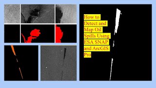
Oil spill detection using SNAP and ArcGIS pro
Просмотров 18421 день назад
🌍 New RUclips Video Alert: Detecting Oil Spills Using SAR Data! 🛢️✨ I’m excited to share my latest video on Space Remote Sensing and GIS, where I demonstrate how to detect and map oil spills using SAR data with the ESA SNAP Sentinel-1 Toolbox and ArcGIS Pro. 🎥 In this video, I guide you through: ✅ Preprocessing SAR Data: Steps like radiometric calibration, speckle filtering, and terrain correct...

How to Generate Precise DEMs from SAR Data with InSAR in ENVI SARscape
Просмотров 171Месяц назад
For today's video on my RUclips channel, which focuses on Space Remote Sensing and GIS, we'll dive into the fascinating process of DEM creation from SAR images using Interferometry with the help of ENVI SARscape. This method employs InSAR (Interferometric Synthetic Aperture Radar) and DInSAR (Differential InSAR) techniques to generate accurate Digital Elevation Models (DEM), as well as Coherenc...
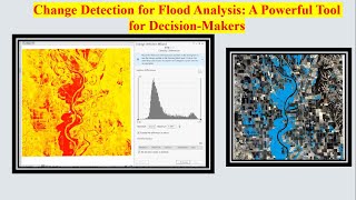
Change Detection for Flood Analysis: A Powerful Tool for Decision-Makers
Просмотров 243Месяц назад
Change detection is an essential tool for understanding shifts in landscapes, especially when analyzing dynamic events like floods. By comparing raster datasets over time, we can detect and quantify changes, helping stakeholders make informed decisions. Imagine you're a GIS analyst for the weather service, tasked with analyzing a recent flood event in the Midwest region of the United States. To...

Transforming Geospatial Data: The Latest Industry Advancements
Просмотров 123Месяц назад
🚀 Exciting Developments in the Geospatial Industry! 🌍 I had the pleasure of delivering a lecture on the latest trends shaping the geospatial industry. We explored some groundbreaking advancements, including: 1. Cloud-Based Drone Data Processing: Leveraging the power of the cloud to process and analyze drone data efficiently. 2. Deep Learning: Utilizing AI to enhance geospatial data interpretati...

How to Create Web Apps in ArcGIS Online: A Step-by-Step Guide
Просмотров 140Месяц назад
🌟 Discover the Power of Web App Development in ArcGIS Online 🌟 In today's video, we're diving into the world of Web App Development in ArcGIS Online and exploring how it transforms the way we share geospatial insights! ✅ Why choose Web Apps over Web Maps? Web apps offer enhanced interactivity, better accessibility, and powerful sharing options to meet the diverse needs of your organization-all ...

Radar vegetation Index in ArcGISPro
Просмотров 261Месяц назад
The Radar Vegetation Index (RVI) is a powerful tool for assessing vegetation health using Synthetic Aperture Radar (SAR) data, and ArcGIS Pro makes it easier than ever to compute this vital index. With RVI values ranging between 0 and 1, you can identify barren areas (closer to 0) and dense vegetation (closer to 1). Here’s how it works: Start by preparing your SAR data-ensure it’s in linear uni...
Hyperspectral Data in ArcGIS Pro: Opening and Analyzing Spectral Curves
Просмотров 2302 месяца назад
Welcome back to Space Remote Sensing and GIS! In today’s video, we’ll explore how to open hyperspectral data in ArcGIS Pro and create spectral curves for different objects. But first, let’s quickly understand what hyperspectral imagery is all about. Hyperspectral imagery is a cutting-edge remote sensing technology that captures and analyzes data from across the electromagnetic spectrum. Unlike ...
How to Download and Process Sentinel-2 Data Using Raster Product Files in ArcGIS Pro
Просмотров 6932 месяца назад
In this video, I will guide you through downloading Sentinel-2 satellite images using the new Copernicus Open Access Hub and exploring the Copernicus Data Space Ecosystem-the latest innovation in Earth observation data. This ecosystem provides instant access to a vast repository of free and open Earth observation data, including both new and historical Sentinel images, as well as data from Cope...
How to Set Up a STAC Connection in ArcGIS Pro: Access and Analyze Cloud-Based Spatial Data
Просмотров 1732 месяца назад
Welcome to Space Remote Sensing and GIS! In today’s tutorial, we're diving into an exciting topic: setting up a SpatioTemporal Asset Catalog, or STAC, connection in ArcGIS Pro. If you’re new to STAC, it's a standardized format designed to make it easy to organize and access a variety of spatial data types-like imagery, SAR, point clouds, data cubes, and even full-motion video-across different p...
Creating a Road Density Map and Layout in ArcGIS Pro: A Step-by-Step Guide
Просмотров 4392 месяца назад
🚀 New Tutorial Alert! 🌍 Understanding road density is crucial for many applications in GIS, particularly in flood risk assessment, urban planning, and infrastructure management. A road density map helps visualize the length of roads per unit area, which can indicate areas that may be more vulnerable to flooding due to potential obstructions and water flow disruptions. I'm excited to share my la...
AI Meets Agriculture: Using Hugging Face for Satellite-Based Crop Classification
Просмотров 5603 месяца назад
Hey everyone, welcome back to Space Remote Sensing and GIS! Today, we're diving into an exciting AI tool: Prithvi AI, developed by IBM and NASA. This cutting-edge temporal Vision Transformer model is trained on Harmonized Landsat Sentinel-2 (HLS) data over the continental US, fine-tuned for multi-temporal crop and land-use classification, making it perfect for agricultural analysis. I used HLS ...
Thresholding ROI for Spectral Signature Collection & Classification Using Maximum Likelihood in ENVI
Просмотров 1253 месяца назад
The purpose of this video is to teach how to classify the most common types of land cover in a Landsat 8 satellite image. Land cover refers to the different types of physical surfaces on the earth, like forests, water bodies, urban areas, and agricultural fields. To identify and categorize these surfaces, we’ll use various tools available in ENVI software. We will use tools like the Band Animat...
PDFs as Raster Layers - ArcGIS Pro 3.3
Просмотров 2543 месяца назад
PDFs as Raster Layers - ArcGIS Pro 3.3
Ecological Risk and Burn Severity Assessment after Wildfires
Просмотров 1334 месяца назад
Ecological Risk and Burn Severity Assessment after Wildfires
Analyzing Avalanche Potential Using the Raster Function Tool in ArcGIS Pro
Просмотров 1654 месяца назад
Analyzing Avalanche Potential Using the Raster Function Tool in ArcGIS Pro
Flood analysis using ENVI and Arcgis pro over SAR
Просмотров 4154 месяца назад
Flood analysis using ENVI and Arcgis pro over SAR
How to Mosaic Satellite Images in ENVI: A Step-by-Step Guide
Просмотров 2934 месяца назад
How to Mosaic Satellite Images in ENVI: A Step-by-Step Guide
How to Mosaic Landsat Data in ArcGIS Pro: A Step-by-Step Guide
Просмотров 4334 месяца назад
How to Mosaic Landsat Data in ArcGIS Pro: A Step-by-Step Guide
How to Automate Geospatial Analysis with ModelBuilder in ArcGIS Pro
Просмотров 2205 месяцев назад
How to Automate Geospatial Analysis with ModelBuilder in ArcGIS Pro
Mastering Spatial Analysis in ArcGIS Pro: A Comprehensive Tutorial
Просмотров 4075 месяцев назад
Mastering Spatial Analysis in ArcGIS Pro: A Comprehensive Tutorial
Ship detection from SAR image in ArcGIS Pro
Просмотров 4305 месяцев назад
Ship detection from SAR image in ArcGIS Pro
Exploring Sentinel-1 SAR Data with ESRI's New Sentinel-1 Explorer Tool
Просмотров 4596 месяцев назад
Exploring Sentinel-1 SAR Data with ESRI's New Sentinel-1 Explorer Tool
Extracting Water Bodies Using Sentinel 1 GRD SAR Data in ArcGIS Pro: A Comprehensive Guide
Просмотров 1,4 тыс.6 месяцев назад
Extracting Water Bodies Using Sentinel 1 GRD SAR Data in ArcGIS Pro: A Comprehensive Guide
Flood Simulation Using ArcGIS Pro 3 3
Просмотров 1,3 тыс.6 месяцев назад
Flood Simulation Using ArcGIS Pro 3 3
Urban Sprawl Mapping ll How to prepare composite map of Dubai II Built-up area Composite map
Просмотров 2556 месяцев назад
Urban Sprawl Mapping ll How to prepare composite map of Dubai II Built-up area Composite map
Semi-automatic Shoreline Delineation and Change Detection in Dubai Using ArcGIS Pro
Просмотров 5837 месяцев назад
Semi-automatic Shoreline Delineation and Change Detection in Dubai Using ArcGIS Pro
Direction and Distance for urban expansion in ArcGIS Pro
Просмотров 3967 месяцев назад
Direction and Distance for urban expansion in ArcGIS Pro
Very interesting. Thank you sir.
Can you do a Video on wetland mapping and monitoring using multi source measurements and using Rainfall and Urbanisation as a driver affecting this wetlands
Hi, what i don't have GCPs, what do I do? Is there any other way I can do to get the ground control points? Thanks for the video!
Hello, do you have this work published. i want to download it
No still this work is not published
when i setlected add datasets there are no dataset that are showing
Yes its possible if you are searching recent data because this satellite stop working from mostly 2017.
This is very helpful - thank you! Is it possible to adapt this technique to find the "edge of riparian dripline"? This is my challenge.
Sir it will be very difficult task to identify the dripline but if you have very good high resolution data like drone. then may be it possible.
thanks broo, hi really appreciate for this knowledge, thanks man
Thank you very much
Can you write me from that WhatsApp or send me your own WhatsApp number?
Is it possible to find cemeteries in underground tunnels?
It's not possible with sentinel 1 satellite data.
how download snap 11
Please download from this below link step.esa.int/main/download/snap-download/
Hlo sir if i am doing DinSAR processing in SarScape........and export image in tiff format for map composistion................. My values for displacement are -0.14 to +0.11 ........ What are its units......if i am using 12 day data.........than this values are for 12 days or year.............. But firstly plz tell me the units of my output.....is it mtrs,cm or mm
Displacement (symbolized d or s ), also called length or distance, is a one-dimensional quantity representing the separation between two defined points. The standard unit of displacement in the International System of Units ( SI ) is the meter (m).
In SARscape processing, specifically for Differential InSAR (DinSAR), the displacement values represent the amount of surface movement detected between two radar acquisitions. These values are typically in meters (m) and reflect the displacement between two radar images, which can be caused by phenomena such as land subsidence, infrastructure deformation, or tectonic shifts. Units of Displacement Values The displacement values you have (-0.14 m to +0.11 m) are in meters (m). This means the surface has shifted by a range of 0.14 meters to 0.11 meters. Displacement Over Time (12-Day Interval) Since you are working with 12-day data, these values represent the displacement over a 12-day period. The values are calculated based on the difference between two SAR acquisitions that were taken 12 days apart. Therefore: The displacement of -0.14 m to +0.11 m is for the 12-day period. If you wanted to scale this to a per-year basis, you would multiply by the number of 12-day intervals in a year. There are approximately 30.42 days per month on average, so a year would have about 365.25 days. Dividing 365.25 days by 12 gives approximately 30.44 intervals per year. To convert your 12-day displacement values to a per-year basis, you would multiply the displacement range by 30.44. For example: -0.14 m per 12 days × 30.44 = -4.26 m per year +0.11 m per 12 days × 30.44 = +3.34 m per year Thus, the displacement over the entire year would be in the range of -4.26 m to +3.34 m, if you scale it up. Exporting to TIFF When you export the displacement map to TIFF format for map composition, ensure that you specify the coordinate reference system (CRS) and any relevant metadata that can clarify the time frame and spatial scale for your map's users. If you need the displacement data to be shown over a specific spatial extent, be sure to handle the geographic projection and scaling appropriately during export.
@spaceremotesensingandgis5626 sir the 4mtr values are very high......for land displacement........values for dispalcement is in. mm .....
If have have to find velocity than i have to divide displacement by time period .....for ex if my displacemnt for 12 days is 0.48mts. Tha to find velocity to do this 0.48/12. Which is 0.4mts. Which is very less value....in comparison to velocity......if we consider 0.48mtr for 1 day than its is suitable for glacier
@@Dr.MeMer5 Its difficult to tell that as I am not much work on glacier. I will check and let you know if I get any information.
please guide about the three dates selection. like which months or period.?
its according to the crop growth you have to select the months.
How can I get that kind of satellite data? Can I use Landsat 8 for that experiment?
Yes you can use that
can u make a video about how you are getting or downloading the data
This video is on that only. Can you please mentioned which data you want to download so that I can help you. This video is on how to download sentinel 2 data.
Hi Friend, Is it possible to classify vessels from SAR Images if AIS is turned off ?
I mean can you also find military ships?
Yes I have one video on ship detection you can check this link ruclips.net/video/JqLAlj0O2-4/видео.html
@@spaceremotesensingandgis5626 but how it will differenciate between a warship and a container. FROM RADAR IT IS POSSIBLE BUT FROM SATELLITE CAN WE CLASSIFY VESSELS?
Is it Radar data available freely
Yes
@@spaceremotesensingandgis5626 please share links
Remove Thermal Noise tool is not working, why?
This may be some trouble shooting issue sent a mail to esri customer care.
Thanks for the video. Do you have any video that shows how RVI is calculated in SNAP or ArcGIS( not Pro)? kindly help, even if its from another source. I need to learn also how to open preprocessed image from SNAP to ArcGIS. I will be grateful for your positive feedback.
Will upload soon
RVI values ranges from 0 to 1, but in this video the value extends beyond 1? And what about the other processes like multilooking? Radiometric calibration of sigma0 ? U have did a direct tool for RVI, so the results is right?
Radiometric calibration need to do. May be that's way value is coming high. I will check the results again. Thanks to mentioned.
Sir, what about the Radar Forest Degradation Index (RFDI) in arcgis pro? And its calculations? The direct tool is seen in arcgis pro, whether this tool uses all the pre-processing in itself?
No calibration may need to do manually
Only thanks is not enough for this informatic video💌
Your words motivating me lots to create more such video like this.
great add more video using SAM and other preprocessing techniques
already there over ENVI soon will post over arcgis pro
very nice actually
Thank you
Hi, thanks for the video. I would like to practice this using your data. May I know if you are able to share the data? Thank you.
I need to search the data please share your mail id. I I got the data I will share it to you
Very informative sir
Thank you very much
Please send ArcGIS Pro crack version
Your teaching approach is very nice, i want to learn from you.
Glad to hear that. It will motivating me lots.
HOW TO MAKE 3D REALISTIC TEXTURE THE MULTIPATCH BUILDING?.....HOW TO IMPORT AGISOFT METASHAPE PSX
pls provide data
Which data you required ?
from where you have downloaded NWIC ground water data? pls share the link..
Its showing in video
What is the scale of this? Can a map of 1/25000 be made in the same way?
Yes you can do that if the data will available.
where do you get your data sir?
This is some project data I used. You can download hyperion data for that cehck my video on how to download hyperion data ruclips.net/video/n059Rj0q36M/видео.html
b11 tiff not available, why?
in landsat 9
It should be available
Please make a tutorial on 3D walkthrough/fly through animation
Sure I will do that
Hi, have you ever noticed a band-misalignment in LISS-IV?
Yes it is there
@@spaceremotesensingandgis5626 I think ISRO has a tool to correct the misalignment
Excellent video 👍👌🙏
Thanks for watching.
@spaceremotesensingandgis5626 your welcome 🙏 excellent 👌
hello sir, thanks a lot for the video, I am trying to to just use real and imaginary parts of vv and vh components with all these corrections like calibration and terrain correction, please explain how to proceed
Yes you can try this with vv and vh component, for details you can refer some research papers and read some thing on basic of sar data processing then you will get the idea.
On EO Browser, Sentinel-1 is showing me the same image on 3 different days (12 days apart). Happens every month. Is there a way to fix this problem?
Its not a problem every 6 days you will get image but out side Europe we are getting 12 days 1 scene.
how do you know where to add a outlet/porpoint?
Mostly where 2 first order stream are joining we will take pour-point there
please, is this the same as forest fire maps? How can I get forest fire maps for different indices, e.g., NBR, NDVI, etc.? Also, was there any atmospheric correction done on this?
Yes you can do this for forest fire assessment. You can use same landsat satellite other bands to estimate other indices. Check my oldest video you will get all information.
Very helpful, thank you!
You're welcome!
@@spaceremotesensingandgis5626 do you by chance have any advice on what to do if the resulting raster looks very choppy? I had to use 4 landsat 8 images and one of them seems to carry wildly different values.
Thanks for the breakdown! 🤔 Need some advice: 🙏 I have these words 🤨. (behave today finger ski upon boy assault summer exhaust beauty stereo over). Not sure how to use them, would appreciate help. 🙏
I did not understand your question
which band landsat images should we consider
normal FCC band is fine for this analysis
Tengo mis datos en metros puedo lograr visualizarlos y como ?
Yes you can check this full video you will get that idea
Want to know from you that Jobs in India or Other country also. And the work (after joining company) is from India or from foreign countries also.
Please reply.
Jobs in GIS sector is good in India and in abroad also. as its a booming technology may in future you will get more opportunity. Only you need to upgrade the IT skill with that will be advantage.
@@spaceremotesensingandgis5626 Thank you for your reply. I am very very confused to decide from BIM (Building Information Modelling) Or GIS/GPS. I have searched Khagolam institute for GIS.. in Mumbai. But for that it related they have 1 year course. And I have 2 years gap. Please tell me what to do now.
How do I get the Hansen global forest loss dataset into ArcGIS pro for the Tapajos area in Brazil? I am looking at road network impact on deforestation and have been told to use the hansen data. How do I get this in and be able to obtain tree loss data per year?
To analyze deforestation changes over time, you can use satellite imagery from different years. A good approach would be to download historical data, such as Sentinel or Landsat satellite images, from the year you want to examine for deforestation. Afterward, download the most recent images from the same area. By comparing these two datasets, you can assess the changes in forest cover and estimate the extent of deforestation over time. Tools like remote sensing software (such as ArcGISPro, ENVI, or Google Earth Engine) allow you to perform change detection analysis, where you can quantify and visualize the deforestation between the two time periods. This method provides a clear, data-driven understanding of environmental changes, helping inform conservation efforts.
Did you digitize the water polygon? I'm curious where you obtained the water polygon. I watch the first part and did not see where this came from. I know you obtained the sea level rise from Living Atlas, but curious about the water poly. I don't want to draw this to delineate water if I don't have to.
I already have the water polygon for the sea, but you can generate a new sea water polygon using various water extraction techniques. These methods involve processing satellite imagery to identify and extract water bodies, allowing you to create an accurate polygon representation of sea water. Techniques such as spectral water indices (like the Normalized Difference Water Index, NDWI) or classification algorithms can help in isolating sea water areas from other features in the imagery. By applying these techniques, you can refine or update the sea water polygon based on more recent or precise data.
i want to do map house build before 1990. how can i do that?
High-resolution satellite images from before 1990 are generally not available. However, if you have access to aerial photographs from that period, it would be possible to extract building information from those images. Aerial imagery, often used before the era of advanced satellite technology, can provide detailed views of the landscape, including buildings. By using modern image processing techniques, you can analyze these aerial photos to identify and extract the structures within the area of interest
FROM WHERE CAN I CAN GET IMAGES
You can download the sample images from satellite agency sites. This all data are not free.
The elevations are not same at arcgis earth and at gps visualizer
Its depends which scale you are comparing
@@spaceremotesensingandgis5626 elevation depends on scale ?
sir, is it possible to get the number of area of the flood?
Yes you can calculate the area under flood
@@spaceremotesensingandgis5626 how sir? do you have any other social media that we can chat?
@@FauxJ this is my LinkedIn profile www.linkedin.com/in/dr-surya-deb-chakraborty-20013922/