
- Видео 113
- Просмотров 146 057
Flying Surveyor
Великобритания
Добавлен 30 мар 2008
I'm on a mission to help construction and land surveying companies use the latest technology to save time, cut costs, and boost efficiency.
I’ve helped businesses implement tools like drones, GNSS systems, and 3D modeling to streamline workflows and achieve incredible results. Now, I want to help even more companies leverage these advancements to transform their projects and grow their bottom line.
On this channel, I cover:
1. How drones and modern tools save time and money.
2. Practical uses of LiDAR, AI, 3D modeling and other surveying equipment.
3. Strategies for integrating advanced geospatial tech.
4. Case studies of companies embracing innovation.
Have a success story about using technology? Email me, and I might feature it in a video! If you're an expert or want to learn how to innovate your business, join my mission-let's shape the future of the industry together.
This iPhone Hack Will SAVE You £2000 on EVERY SURVEY JOB!
Need Land Surveying Assistance? 👇
www.stefanengineering.co.uk/contact
📱 Connect on LinkedIn: www.linkedin.com/in/stefan-niculescu-80150853
Video Chapters:
00:00 Introduction
00:08 How I Saved Money With Pix4D x Emlid
01:46 Process Data With Pix4Dmatic
11:06 Limitations Pix4D x Emlid Kit
12:07 Best Use for Pix4D x Emlid Kit
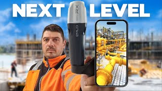
Discover how a simple tool transformed the way I handle small topographical surveys in busy city centers. In this video, I’ll share my real-world experience of completing a challenging survey job in Edinburgh just before Christmas-without the hassle of bulky gear, parking struggles, or extra expenses.
Using the Pix4D and Emlid RX system, I saved over £2,000 in costs, avoided hour...
www.stefanengineering.co.uk/contact
📱 Connect on LinkedIn: www.linkedin.com/in/stefan-niculescu-80150853
Video Chapters:
00:00 Introduction
00:08 How I Saved Money With Pix4D x Emlid
01:46 Process Data With Pix4Dmatic
11:06 Limitations Pix4D x Emlid Kit
12:07 Best Use for Pix4D x Emlid Kit
Discover how a simple tool transformed the way I handle small topographical surveys in busy city centers. In this video, I’ll share my real-world experience of completing a challenging survey job in Edinburgh just before Christmas-without the hassle of bulky gear, parking struggles, or extra expenses.
Using the Pix4D and Emlid RX system, I saved over £2,000 in costs, avoided hour...
Просмотров: 332
Видео


You Will Save HOURS Daily with This Simple AI Hack!
Просмотров 36521 день назад
Need Land Surveying Assistance? 👇 www.stefanengineering.co.uk/contact 📱 Connect on LinkedIn: www.linkedin.com/in/stefan-niculescu-80150853 Video Chapters: 00:00 Introduction 00:33 Extract Coordinates for Setting Out 02:21 Steel Drawing Info Extraction In this video, we show you how ChatGPT can help you quickly extract important details from construction drawings, like coordinates for setting ou...

Is 3D Modeling REALLY the Future of Construction Industry?
Просмотров 978Месяц назад
Need Land Surveying Assistance? 👇 www.stefanengineering.co.uk/contact 📱 Connect on LinkedIn: www.linkedin.com/in/stefan-niculescu-80150853 Is 3D technology really the ultimate solution for construction? In this video, I uncover the surprising truth about 2D drawings and why they remain indispensable on construction sites today. Despite the rise of 3D models, drones, and laser scanners, 2D drawi...

Earn £80,000 per Year WITHOUT a Degree! Here’s How!
Просмотров 501Месяц назад
Need Construction Site Assistance? 👇 www.stefanengineering.co.uk/contact 📱 Connect on LinkedIn: www.linkedin.com/in/stefan-niculescu-80150853 Video Chapters: 00:00 Introduction 00:43 Why This Career is in Demand 01:24 A Personal Story 02:16 What is Construction Setting Out? 03:09 How to Get Started Discover how you can start a rewarding career as a setting out engineer in construction, earning ...
I Saved THOUSANDS with This iPhone 3D Scanning Hack!
Просмотров 1,9 тыс.2 месяца назад
Need Geospatial Consultancy? www.stefanengineering.co.uk/contact 📱 Connect on LinkedIn: www.linkedin.com/in/stefan-niculescu-80150853 Video Chapters: 00:00 Introduction 00:42 Setup 00:53 How Easy is To Use? 03:05 Accuracy Emlid x Pix4D Kit 06:19 Price and Value 07:52 My Conclusion Imagine turning your iPhone into a powerful, professional surveying tool with centimeter-level accuracy. In this vi...

AI in Land Surveying: The BEST Way to STAY AHEAD of the GAME!
Просмотров 3403 месяца назад
Need Geospatial Consultancy? www.stefanengineering.co.uk/contact 📱 Follow Me: LinkedIn: www.linkedin.com/in/stefan-niculescu-tcinstces-80150853/ Are surveyors becoming obsolete with the rise of AI and robotics in 2024? Last week, I attended Intergeo 2024, the world's biggest geospatial expo, to find out. In this video, I share my thoughts on the latest geospatial tech trends, including drone an...

Want ACCURATE Drone Maps for Surveying? Here's the Secret!
Просмотров 7384 месяца назад
Need Geospatial Consultancy? www.stefanengineering.co.uk/contact 📱 Follow Me: LinkedIn: www.linkedin.com/in/stefan-niculescu-tcinstces-80150853/ Video Chapters 00:00 Introduction 00:56 Site Surveying 01:33 Data Process 02:57 Comparing the Results 06:39 Case Study 10:00 My Conclusion In this video, we conduct a real-life test to determine how accurate drone surveying really is. We'll cover mappi...

Take Surveying to the Next Level With THIS Drone
Просмотров 4624 месяца назад
Need Geospatial Consultancy? www.stefanengineering.co.uk/contact 📱 Follow Me: LinkedIn: www.linkedin.com/in/stefan-niculescu-tcinstces-80150853/ The WingtraOne Gen II is a cutting-edge vertical takeoff and landing (VTOL) drone specifically designed for professional surveying and mapping. It combines the efficiency of fixed-wing flight with the flexibility of vertical takeoff and landing, making...

Is This the FUTURE of Construction Setting Out?
Просмотров 1,1 тыс.4 месяца назад
Need Geospatial Consultancy? www.stefanengineering.co.uk/contact 📱 Follow Me: LinkedIn: www.linkedin.com/in/stefan-niculescu-tcinstces-80150853/ The Leica iCON iCS50 is an advanced construction tool designed to handle both simple and complex layout and 3D measurement tasks with ease. It is easy to learn and efficient to use. When used with the smart accessories Leica vPole and Leica vPen, it be...
I Spent 20 years Mastering RTK GNSS and Here's What I Learned!
Просмотров 1,1 тыс.4 месяца назад
Need Geospatial Consultancy? www.stefanengineering.co.uk/contact 📱 Follow Me: LinkedIn: www.linkedin.com/in/stefan-niculescu-tcinstces-80150853/ Video Chapters 00:00 Introduction 00:27 History of Satellite Positioning 01:04 How GNSS Systems Work 02:11 How RTK Works 04:21 Fixed and Float Solutions 05:27 CORS Networks 07:04 UK's CORS Networks 07:43 My Conclusion
Road Construction Secrets EXPOSED in the Scottish Highlands
Просмотров 755 месяцев назад
Need Geospatial Consultancy? www.stefanengineering.co.uk/contact 📱 Follow Me: LinkedIn: www.linkedin.com/in/stefan-niculescu-tcinstces-80150853/ Witness the incredible transformation of the Scottish Highlands as we take you on a breathtaking aerial journey over a road construction site nestled in the heart of this stunning landscape. Filmed entirely with drone footage, this video showcases the ...
Avoid the Top Construction Mistake That's Costing You Money
Просмотров 2025 месяцев назад
Need Geospatial Consultancy? www.stefanengineering.co.uk/contact 📱 Follow Me: LinkedIn: www.linkedin.com/in/stefan-niculescu-tcinstces-80150853/ In this video, I share a real-life story of how I lost a client due to a critical mistake that wasn't even my fault. As a Land Surveyor with nearly 20 years of experience, I explain how the lack of a proper topographical survey led to a costly construc...
Can Emlid Flow Surface Features Really Deliver?
Просмотров 8935 месяцев назад
Need Geospatial Consultancy? www.stefanengineering.co.uk/contact 📱 Follow Me: LinkedIn: www.linkedin.com/in/stefan-niculescu-tcinstces-80150853/ Welcome to our latest video where I put the new surface tool in Emlid Flow to the test! Earthwork has never been easier. With this revolutionary feature, you can import your surface models in LandXML format into Emlid Flow 360 and stake them out direct...
You Won't Believe the Crazy Process Behind Creating Accurate Maps
Просмотров 2,1 тыс.5 месяцев назад
Need Geospatial Consultancy? www.stefanengineering.co.uk/contact 📱 Follow Me: LinkedIn: www.linkedin.com/in/stefan-niculescu-tcinstces-80150853/ Did you ever wondered what the true shape of the Earth is? It's not flat, and it's not perfectly round either. In this video, we dive into the fascinating world of geodesy and cartography to explain the Earth's shape, from geoids and spheroids to map p...
This Product IMPROVED my Construction Setting Out
Просмотров 8076 месяцев назад
This Product IMPROVED my Construction Setting Out
I Discovered the BEST Mobile App for Construction Site Photos
Просмотров 4236 месяцев назад
I Discovered the BEST Mobile App for Construction Site Photos
EASY WAY to Import Orthophotos into AutoCAD and BricsCAD Like a Pro
Просмотров 1,3 тыс.6 месяцев назад
EASY WAY to Import Orthophotos into AutoCAD and BricsCAD Like a Pro
Pricing Mistakes That Are COSTING Businesses THOUSANDS
Просмотров 1417 месяцев назад
Pricing Mistakes That Are COSTING Businesses THOUSANDS
Master Drone Mapping in LESS Than 2 minutes
Просмотров 4067 месяцев назад
Master Drone Mapping in LESS Than 2 minutes
You Won't Believe How Easy Drone Mapping Can Be with QGIS
Просмотров 9467 месяцев назад
You Won't Believe How Easy Drone Mapping Can Be with QGIS
Survey Accessories CHANGED the Game for Surveying Business
Просмотров 4447 месяцев назад
Survey Accessories CHANGED the Game for Surveying Business
Venus Laser RTK FIGHTS Traditional Surveying Methods!
Просмотров 1,9 тыс.7 месяцев назад
Venus Laser RTK FIGHTS Traditional Surveying Methods!
Insta360 Takes on DJI Which is Better for EPIC Travel Videos?
Просмотров 1018 месяцев назад
Insta360 Takes on DJI Which is Better for EPIC Travel Videos?
One Month with Emlid Reach RS3 - The Surprising TRUTH
Просмотров 10 тыс.9 месяцев назад
One Month with Emlid Reach RS3 - The Surprising TRUTH
Survey Ground Control Points Like a PRO with Emlid GNSS !
Просмотров 1,7 тыс.9 месяцев назад
Survey Ground Control Points Like a PRO with Emlid GNSS !
Building A POWERFUL Setting Out Network From Scratch
Просмотров 6329 месяцев назад
Building A POWERFUL Setting Out Network From Scratch
Master Trimble Data Export in LESS than 3 Minutes!
Просмотров 78010 месяцев назад
Master Trimble Data Export in LESS than 3 Minutes!
The 5 Critical Drone Mapping Mistakes You're Making Right Now
Просмотров 3,8 тыс.10 месяцев назад
The 5 Critical Drone Mapping Mistakes You're Making Right Now
Avoid These VIDEO MARKETING Mistakes At All Costs
Просмотров 3010 месяцев назад
Avoid These VIDEO MARKETING Mistakes At All Costs
You asked about the Traverse tool in Emlid Flow. It is for setting out additional points using Easting and Northing values like are found on typical plot plans. Starting from any point, you can "Traverse" to find the next point.
Thank you for your comment!
Can you use it in the dark?
@@henky0_095 good question actually. I don't know but I am curious too. I didn't see one yet in the UK
Great video, Stefan! 👏🎬
Nice one Stefan!🎉🎉🎉
can you use this on the rc2 controller?
It doesn’t work with RC2 controller
Nice! is possible to usi it indoor as a rover using outside an emlid rs3 as base station?
No because you don’t have satellite signals indoor. You can use the targets indoor.
How much is this DGPS in Nepal? Is it convenient?
Sorry, I don’t know. You can check they website: hk.store.emlid.com/collections/all-products
So the rs3 can get survey grade accuracy with ntrip and no base station?
@@StumpyHead79 I explain how RTK works in this video: ruclips.net/video/T3ndOYUxIn4/видео.htmlsi=Ld7TI_EZRqLncGfe
Very useful and informative video. Thanks for doing this.
Good info. Thanks!
I agree with you totally
Very helpful.
Great vid
Stop it yourself.
in my view a key diffrence for construction workers should use 2d because of how annoying a computer would be to carry around
@@Dille0509 exactly, plus imagine the costs because is very likely that those tablets or laptops will get damaged 😅
great video Stefan! La multi ani in 2025 :)
Multumesc frumos si un an nou fericit!
Great video! The best way to enhance the functionality of the Emlid RS units is to use Field Genius for Android. It is a small additional cost to drastically improve the survey functionality. Again thank you for a great video.
I can't seem to find this field genius. Can you link it?
@@danaiduma Search "Microsurvey FieldGenius"
X12 top self scanner. Also, 6 figures
It is a great laser scanner and the price reflects that 💰💰💰
Hi Stefan, I'm just getting into drone mapping and looking at GCP for improving accuracy. From other videos I have seen It looks like you need to buy expensive receivers to get co-ordinates. Is there any other way to get the lon&lat, and elevation data using natural features like corners of paths/fences, without buying one of these receivers?
@@IrelandOutdoors it depends of the accuracy. If you want to make orthophotos that are centimetre acurracy, then I am afraid that you will need a GPS receiver and maybe a NTRIP subscription. If you looking just to make orthophotos for general information and 1-2m accuracy is not a problem then you don't need GCP's. I was hiring the GNSS receiver before buying one and put it on the job cost. It was around £100 with VAT per day.
Great video Stefan, I like the storytelling! 👏🏻
@@mariolyubenov522 thank you very much, I am glad you found it useful!
Great vid as always!
@@dylanhorne thank you very much, I am glad you found it useful!
Hello, I am a surveyor from Nigeria. Could you please advise me on how to obtain a sponsored visa as a skilled worker in the UK construction industry?
@@sulaiman567 hi, I think that you need to be sponsored by eligible company
@flyingsurveyor could you provide link or how can I get company who are capable of sponsorship? Thanks
@@sulaiman567 www.gov.uk/skilled-worker-visa
@@flyingsurveyor thanks
Good video. Thanks
Thanks for getting back to me! The problem with rotating laser levels is that they’re quite slow and tedious when it comes to converting measurements into AutoCAD. For example, if we need to capture 20 points, we have to manually measure the X and Y distances and the Z height with the laser, then input everything into CAD. Is there a device similar to a rotating laser that can directly provide results in CAD to make things easier?
Ok, now I understand what you guys are looking for. Emlid Reach RS3 or even Emlid RX the small one will be great for you as long as you have clear sky. It does export your points as DXF format for AutoCAD. You will need a NTRIP license that can be around 2000 USD per year or you can buy base and rover but is a bit more complicated. Another method to survey X,Y,Z coordinates is to buy or hire a Total Station that is more complex, very expensive and requires even more training so this GPS is probably more suitable for you. Check out my other video to understand how RTK works and if you go on this route and get stuck you can find my details in the video description and we can have a chat.
Hi We are a civil engineer company and something needs to check the grading elevations for small projects. Do you suggest this emlid 3 for this type of project? Please note we are not a survey company or surveyor and prefer to don't pay the monthly subscription fee for the device. Please advise
Hi there, if you do only small projects and you need to check elevations is better just using a rotating laser lever. GPS antennas is more suitable for setting out road and bigger areas. On top of that you will need a NTRIP subscription and you will need to learn how to use AutoCAD to import and export data. I made another video about how GPS RTK technology works you can check it out to make yourself an idea: ruclips.net/video/T3ndOYUxIn4/видео.htmlsi=rZYC6nnM-XB7qZyo
Thank you for your response. The main issue with using a rotating laser level is the inefficiency-it’s quite time-consuming to convert the measurements into AutoCAD. For example, capturing 20 points requires manually measuring the X and Y distances and determining the Z elevation with the laser, which then needs to be input into CAD to draw them. Is there a device similar to a rotating laser level that can directly provide output compatible with AutoCAD? Please note that we do not require geodetic points; local points would be sufficient for our needs.
I would check out Bad Elf. I work for SUE firm in PA and it’s as accurate as it gets. I use a base and rover set up to avoid subscriptions. This also allows me to work without internet connectivity.
I notice all the control points were very close, like within a few meters. I assume control points that are some distance apart are going to be roughly the same accuracy as long as you have RTK fixed solutions? How does distance from the camera to the points affect accuracy? I imagine there's a distance where the accuracy begins to rapidly fall off.
@@ryanmcgowan3061 those points were only surveyed points not control points. Control points are when you use the targets, but there are more useful indoor when you dont have GPS signal. Exactly, each photo has its own RTK position so the point cloud is pretty accurate, within a few centimeters. The scanning distance should not be bigger than 5m. Good thing is that is light and mobile. I scanned even a 200m road section with this kit and had good results
REALITY
Muito bem explicado e com grande objetividade. Parabéns!
@@Aquacalidae muito obrigado!
آیا نرم افزار ترسیم پروفیل طولی و عرضی هم داره؟
No, but you can export data to use with other software. At the moment calculates only volumes
دو روز اخیر یک تونل تاسیسات زیرزمینی به طول 500 متر و به ارتفاع و عرض حداکثر 2 متر با total station کار کردم. آرزو میکردم بتونم با اسکنر انجام بدم. اما هزینه زیادی داره. pix4d catch رو توی اتاق، امتحان کردم و خروجی اوریجینال گرفتم. اما هنوز موفق نشدم خروجی dwg بگیرم و مساله بعدی، ترسیم پروفیلهای طولی و عرضی هست که خیلی دوست دارم مثل نرم افزارهای مخصوص اسکنر، بصورت خودکار و نه دستی تولید کنم.
استفان 4000 دلار با آیفون یا بدون آیفون؟
The price is without the iPhone
Great video Stefan. It’s on my shopping list.
It's a useful tool
nice video. It is an interesting package but how much is the cost after the first year? I believe the price is to purchase the gnss and pole and first year of subscription. But how much would it be afterwards?
Thank you for your comment! The price is for the kit and one year of subscription, and after you will need to buy at least the Pix4D Catch subscription to use the RTK corrections. The prices are on Pix4D website and they are know for having premium prices but they do offer good and user friendly products. It’s a decent survey tool and I belive that some companies will still see value and will pay the subscriptions after first year.
What kind of drone ?
DJI Mini 2
How hard it is to download a plan into the software?
@@0013baseball it’s easy look at 5:27 , I talk the about it
Hi, chcnav gps is much better choice
I didn't test it so I can't say anything about it yet
Hi, very nice video. What kind of surveying software do you use ?
@@Neema1135514 thank you! I use LSS Software and BrycsCAD
Interested to know more about LSS ? Is that a full survey & CAD software?
@@nimaljayamaha2291 it's a surveying software. You can find more details here: www.dtmsoftware.com/
AI can replace surveyors only if use the pickhamers afterwards.
It's not going to happen too soon
Great comparison and general advice. Had to replay many times lols😅
@@SymonPixel thank you very much! I am glad that you find it useful.
Out of curiosity, how much processing power did processing the footage take? And how long was the raw footage?
My processing computer had Intel i9, graphic card GeForce RTX 4070, and 64 RAM Memory and I processed 275 photos. You can use Capture Reality with lower specs like 16 GB RAM and a lower specs dedicated graphic card but it takes longer to process.
Great Video Stefan. Yep looks the code library could do with updating so that the line is also in the correct layer. Fieldgenius is the best for that and you can use it with nearly all GNSS receivers even this Emlid Reach.
@@petertips2686 I agree that the field software is not as mature as other software. There have have been some updates since I posted the video but there is still a lot of stuff to improve. I had a chat last week at Intergeo with the Emlid Developing team, suggested also this issue and they been very open to suggestions.
Virtual👍
Another great vid👍Reality
@@topdronepilot thank you 👍🏻
Salutare. Drona este rtk sau georeferentierea s'a facut doar cu ajutorul gcp'urilor?
Drona este DJI Air 2s, iar georefentierea este facut cu ajutorul GCP. Am vrut sa aleg cel mai banal caz, cu o drona mai basic.
Am inteles. Da bine ca acuratete.
@@adis4849 cum am zis in video, depinde de suprafata, overlap si de numarul si pozitionarea punctelor de control. Dureaza mai mult decat cu drona RTK dar este posibil sa obtii rezultate bune
Virtual
Reality
Looks ghey AF. Too bulky. I'll stick with my tried and true prisms.
great stuff. How much does the 3 day pass cost for inter geo?
I think it it was 130 euro, but there were different company that give free invitations
Hi, Good job if you have the option to work with geodnet receivers and rs3 to check it's accuracy it would be great.
@@kousalya1724 I have a video about Emlid RS3 ruclips.net/video/H4utjJGC5GM/видео.htmlsi=03rfln0yvVgJoLjh With Geodnet I didn’t work yet, but I recommend Emlid, check out the video
Awesome video and explanations! Congrats for the content.
@@lztoniolo thank you 🙏🏻