
- Видео 115
- Просмотров 6 070
Geodesy Digital Academy
Швеция
Добавлен 19 апр 2024
In this channel, I will share my video lectures that I made for my students. The basic geodetic courses are mainly in Swedish, but the advanced courses in English.
I also created a video interview series with the title "Distinguished Geodesists" where I invited known geodesists for talking about the subject.
I hope that this channel will be helpful for promoting Geodesy.
Mehdi Eshagh.
I also created a video interview series with the title "Distinguished Geodesists" where I invited known geodesists for talking about the subject.
I hope that this channel will be helpful for promoting Geodesy.
Mehdi Eshagh.
3-5 Reduction of distance and heights
Distances between points on the Earth's surface need to be reduced to the surface of the ellipsoid. In this lecture, the method and procedure for performing this reduction are presented using a spherical approximation.
Heights can also be reduced, or levelling can be carried out on the ellipsoid's surface, but this requires determining the double vertical angles between the two points. This method is, in fact, the classical approach used for trigonometric height determination from mountaintops.
This brief lecture explains these reductions in a clear and pedagogical manner.
Просмотров: 32
Видео

3-4 Geometric reductions, Reduction of horizontal angles
Просмотров 5515 часов назад
This video lecture describes the geometric reduction of directions, azimuths, and horizontal angles. After removing the effects of the Earth's gravity field from the vertical and horizontal directions, the impact of the differing geometry between the plane and the ellipsoid must be considered. The first reduction addresses the skewness of the normals to the ellipsoid at the points of observatio...

3-3 Reduction, Physical Reductions
Просмотров 7922 часа назад
All measurements are conducted on the Earth's surface using planar geometry, where distances are defined as straight lines and angles as parts of a plane limited by those lines. In this case, the datum is a plane. However, the Earth's horizontal datum is an ellipsoid, which follows a different geometry. Distances on this ellipsoid are geodesic curves rather than straight lines, and angles are p...

3-2 Horizontal Datum Parameters
Просмотров 73День назад
Since the geoid is not a suitable surface for defining coordinates and geometric quantities, we select a biaxial ellipsoid, which is more suitable due to its smoother shape. Depending on the domain fitting of this ellipsoid to the geoid, two types of datums can be defined: a global datum, where the ellipsoid is fitted to a global geoid (covering the entire Earth), or a local datum, where a part...

3-1 Astronomical and geodetic coordinates and their relations
Просмотров 137День назад
Based on our understanding of Earth's shape, two coordinate systems are used to position points on its surface. When considering the physical shape, or geoid, the coordinate system is known as the astronomical coordinate system. When the mathematical shape, or ellipsoid, is used, it is referred to as the geodetic coordinate system. In both systems, four geometric quantities-longitude, latitude,...

Interview with Professor Harald Schuh
Просмотров 185День назад
Professor Harald Schuh is a distinguished geodesist renowned for his research in Earth rotation, VLBI, GNSS, and ionosphere and troposphere modeling. He is currently active at the Technical University of Berlin and serves as the Head of the Department of Geodesy at the German Geoscience Research Centre (GFZ). Join me as we listen to his insights and reflections on Geodesy, drawn from over 45 ye...

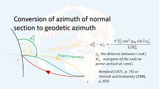
2-4 Normal Section Azimuth and Geodesic
Просмотров 15421 день назад
The normal sections at two different points on the surface of a biaxial ellipsoid are skewed, meaning they are neither parallel nor intersecting. Moreover, they cannot lie within a single mathematical plane. As a result, the normal section from point A to B does not coincide with the normal section from B to A, or the reverse normal section. Therefore, these two normal sections will have differ...

2-3 Radii of curvatures on the ellipsoid
Просмотров 9121 день назад
A biaxial ellipsoid does not have constant curvature like a sphere. Therefore, at any point on its surface, two different radii of curvature are defined. In this lecture, after introducing the concept of normal sections, the prime vertical and its radius, as well as the meridian radius of curvature, are defined, and their mathematical formulae are presented (without proof). Subsequently, differ...

2-2 Different latitudes
Просмотров 14121 день назад
Due to the unique shape of a biaxial ellipsoid, three types of latitudes can be defined to represent the north-south coordinate of a point. In this lecture, after introducing the concept of the normal to an ellipsoid, the geodetic, geocentric, and reduced latitudes are defined. Their geometrical and mathematical relationships are then explained. Finally, a numerical example is provided to demon...
2-1 Ellipsoid's parameters
Просмотров 5921 день назад
In this video lecture, the parameters of an ellipsoid such as semi-major and semi-minor axis, first and second exccentricity, linear exccentricity are explained with figures.
1-3 Geodetic Datum
Просмотров 12021 день назад
Datum is an important concept in geometric Geodesy. All geometric quantities are defined at a mathematical surface. In Surveying the computational space is a plan, but in Geodesy it is a biaxial ellipsoid. Therefore, the datum of surveying is plan and that of Geodesy is the biaxial ellipsoid. In short, datum is mathematical surface at which computations are done. In this video lecture the conce...
1-2 Heights, deflection of the vertical
Просмотров 9921 день назад
It is important to connect Terrain, Geoid and Biaxial ellipsoid, as each on of these surfaces is suitable for specific tasks. measurements are mainly done at Terrain, but the heights have the geoid as the reference, and the coordinates should be computed at the surface of the ellipsoid. In this video lecture, these connections are defined via heights and deflection of the vertical.
1-1 Shapes of the Earth
Просмотров 22521 день назад
Three shapes are defined for the Earth for so that we can perform measurement and computations. Terrain the Earth's surface, that part of the Earth where we can see and live at. The physical shape of the Earth, or the geoid, which has the best fit to the mean sea level, and with a approximation of about 72 % represents the shape of the Earth. Finally, the mathematical shape of the which is a bi...
6-9 Satellite Altimetry Eddy's kinematic
Просмотров 29Месяц назад
Circular motion of water over ocean is called Eddy currents. The kinematics of these currents are estimated from the geostrophic velocities. In this video, lecture, the process of estimating these kinematics are explained.
6-8 Satellite Altimetry Geostrophic velocities
Просмотров 17Месяц назад
Geostrophic velocities are oceanographic concepts in Oceanography. By using the satellite altimetry data, or sea surface height, these velocities can be determined. In this video, the principle of driving them from SSH is explained.
6-6 Satellite altimtery and mean curvature of geoid
Просмотров 21Месяц назад
6-6 Satellite altimtery and mean curvature of geoid
6-5 Satellite altimtery and gravity field modelling
Просмотров 47Месяц назад
6-5 Satellite altimtery and gravity field modelling
6-4 Satellite altimetry and gravity anomaly determination
Просмотров 33Месяц назад
6-4 Satellite altimetry and gravity anomaly determination
Interview with Professor Riccardo Barzaghi
Просмотров 2263 месяца назад
Interview with Professor Riccardo Barzaghi
Lecture 6-2 Satellite Altimetry, Sea Surface Topography SST
Просмотров 313 месяца назад
Lecture 6-2 Satellite Altimetry, Sea Surface Topography SST
Lecture 6-1 Satellite Altimetry Principle
Просмотров 543 месяца назад
Lecture 6-1 Satellite Altimetry Principle
Lecture 5-2 Doppler Positioning principle, DORIS
Просмотров 753 месяца назад
Lecture 5-2 Doppler Positioning principle, DORIS
Lecture 4-4 Very long baseline interferometry by satellites
Просмотров 313 месяца назад
Lecture 4-4 Very long baseline interferometry by satellites
Lecture 4-3 Very long baseline interferometry's forms, applications and considerations
Просмотров 253 месяца назад
Lecture 4-3 Very long baseline interferometry's forms, applications and considerations
Lecture 4-2 Very long baseline interferometry's mathematical model
Просмотров 593 месяца назад
Lecture 4-2 Very long baseline interferometry's mathematical model
Interview with Professor Martin Vermeer
Просмотров 1563 месяца назад
Interview with Professor Martin Vermeer
Really informative, thanks for sharing Dr. Eshagh.
I like your channel as am learning alot in preparation for my masters degree….i would appreciate it if you could point me towards these on your channel(i have come across some by the way but would appreciate if you could touch them again): 1 Geocentric and local cartesian coordinate systems, ellipsoidal coordinates, coordinate transformations, geodetic datums and transformation 2. Elements of spherical trigonometry (great circles, spherical triangles), geodesic lines 3. Differential geometry: parametric equations of curves and surfaces Differential equations as relevant for geodesy 4. Geodesic lines and normal section curves on the ellipsoid 5. Surface coordinates on the sphere and the rotational ellipsoid: geodetic polar and parallel coordinates, isothermal coordinates, transformation of surface coordinates, applications in land surveying(eg. UTM-and Gauß-Krüger coodinates) 6. Series, Taylor Expansions
And also how they all are related to each other
Thank you very much for your comments. This course is not finished yet. Coordinates systems and transformations, and map projections will come. Some of the parts that you mentioned are already created. Please look at the playlist Geodetic Reference Systems. By the way, I am not thinking to teach differential geometry, and differential equations, but I can point to them . Thank you again for your attention and remarks.
Have you seen this ruclips.net/video/qC4L9oWEMkQ/видео.htmlsi=MnsQxNOPX8rFiw33
ruclips.net/video/hIL_lg2NGsc/видео.htmlsi=aZ3XT5cqyRbbTKFq
ruclips.net/video/CDWOPwxyWfU/видео.htmlsi=QgCOqjFcHpK7iCfh
Great lecture, thanks for your efforts.
Nice job Mehdi thanks...
Thanks a lot for your great interview and nice topic
This was very insightful. Being flexible is a key point for me.
❤
Thanks for your nice lecture
🙏 Thanks
Thanks for your video
so impressive
Thank you for hosting Prof. While at the geoid school, he encouraged us not to give up on geodesy. The things that he knew were learnt over 30 years, this was great. Thank you
Very nice, Thanks for sharing
very nice, as always
Thanks for sharing
Thanks
Great interview 👏👏👏👏
People doing this geodesy video's are very bed
Do you see any issue in this video?
Professor Vermeer's ideas and points of view really inspired me! Nice Job!😍
This is amazing. My highlight is on the two main events (Satellite navigation systems and satellite gravity missions) in geodesy.
That was very interesting
Great interview! It gives a good insight into #geodesy. It aligns with our goal at IAG-GGOS to promote geodesy.
Welcome to see more of such interviews. More will come soon.
Interesting Interview giving a great insight into #geodesy. Thank you! I think the geodetic community will see more. It totally aligns with our goal at IAG-GGOS to promote geodesy.
Insightful 👏 thank you 🙏🏻
interesting
Thak you 😎👌🏻🙏🏻🙏🏻🙏🏻
Thanks Prof. Hwang for sharing your path in geodesy and for always replying to my emails. #Inspired to keep going on this path
greeat💐👏
Very excellent lecture ❤
Many thanks
Prof's insight was quite educative and revealing... Thank you for this opportunity.
Great to See you and Prof. Sjöberg
Thanks for created this opportunity 🙏🏻😎👌🏻
Thanks Prof for this session
really interesting
It was interesting interview, Thanks for sharing
Wonderful 👍👍👍