
- Видео 30
- Просмотров 629 022
QGIS WORLD
Непал
Добавлен 10 фев 2021
QGIS WORLD delivers content that helps in several spatial analysis processes with the video ranging from beginner to pro level.
On our RUclips channel, you can expect videos that will help you in creating, editing, analyzing, and layout your GIS project in QIGS platform.
We upload 5 to 10 videos a month with short duration clips as much as possible. Stay tuned to the channel to get to know how versatile the QGIS is now.
On our RUclips channel, you can expect videos that will help you in creating, editing, analyzing, and layout your GIS project in QIGS platform.
We upload 5 to 10 videos a month with short duration clips as much as possible. Stay tuned to the channel to get to know how versatile the QGIS is now.
Downloading Digital Elevation Model (DEM) for free
Here in this video, we will download 12.5 meters terrain corrected DEM for free.
link for the website: asf.alaska.edu/
link for the website: asf.alaska.edu/
Просмотров: 19 074
Видео


Download climate data (Temprature, precipitation and humidity) from 1981 to 2021 for free
Просмотров 7 тыс.2 года назад
Here, we download Temprature, precipitation and humidity data from 1981 to 2021 for free. Along with that we prepare the figure as per the data. The link for the website to download the data for free is : power.larc.nasa.gov/data-access-viewer/ Please subscribe the channel Like and share the video Happy learning!!!!

Prepare map in QGIS || Introduction to QGIS print Layout
Просмотров 133 тыс.2 года назад
Here we will prepare a map in QGIS. After this tutorial you will able to make the map of your own concept in QGIS print layout. Please subscribe the channel! Like and share the video Data link to practise along with the video: drive.google.com/file/d/1wu_8UdRi1Pz5bdfQ8UWcIiaCDDa0nCnJ/view?usp=share_link Practice along with the video with above link and you will be almost perfect on QGIS print l...

Calculate Sediment Transport Index in QGIS
Просмотров 3,6 тыс.2 года назад
here, in this video we will be calculating sediment transport index in QGIS link of the DEM: drive.google.com/file/d/1WKp1yOEqyipgmWMX8duP5yIeBUH17DLA/view?usp=sharing Please like and share the video. Subscribe the channel as well. Let’s remove the barrier in education!! Happy learning QGIS WORLD
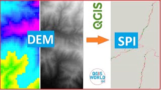
Calculate Stream Power Index (SPI) in QGIS
Просмотров 2,9 тыс.2 года назад
Here, we will learn to claculate the SPI or Stream power index in QGIS Happy learing QGIS WORLD

Calculate TWI in QGIS
Просмотров 8 тыс.2 года назад
Hello! Welcome to QGIS WORD In this tutorail we are going to calculate topographich weightness index (TWI) in QGIS

Convert Shape file to Auto CAD file
Просмотров 4,1 тыс.2 года назад
Hello! Welcome to QGIS WORD In this tutorail we are going to convert shape file to Auto CAD file in QGIS
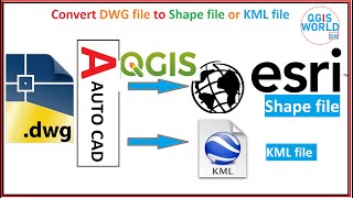
How to convert DWG file to Shape file using QGIS
Просмотров 46 тыс.2 года назад
Welcome everyone to QGIS WORLD! In this video we will convert DWG file to Shape file or KML file using QGIS

Convert Shape file to KML file in QGIS
Просмотров 18 тыс.2 года назад
In this video we will be converting Shape file to KML file using QGIS
Convert KML to Shape file in QGIS
Просмотров 16 тыс.2 года назад
In this video we will be converting KML/KMZ file to shape file using QGIS
Import coordinates to QGIS from EXCEL file (CSV)
Просмотров 6 тыс.3 года назад
here, you will learn step by step procedure to import coordinates to QGIS from excel file (CSV) Genarate stream order map in QGIS: ruclips.net/video/-fr9V9hj_IM/видео.html Make distance from river or stream map:ruclips.net/video/Qvm4A5bIUqY/видео.html Generate catchment area or watershed area in QGIS:ruclips.net/video/CE7zZCkFbg4/видео.html Introduction to watershed area in QGIS: ruclips.net/vi...
Generate river network in QGIS || Generate stream network in QGIS
Просмотров 26 тыс.3 года назад
Here is the step by step procedure to generate stream or river network in QGIS using DEM Link for the DEM to practise along with the video: drive.google.com/file/d/1WKp1yOEqyipgmWMX8duP5yIeBUH17DLA/view?usp=sharing Genarate stream order map in QGIS: ruclips.net/video/-fr9V9hj_IM/видео.html Make distance from river or stream map:ruclips.net/video/Qvm4A5bIUqY/видео.html Generate catchment area or...
Generate distance from stream map in QGIS || Generate distance from river map in QGIS
Просмотров 5 тыс.3 года назад
Here in this video we will show the step by step process to derive the stream proximity map or distance from river map or distance from stream map of stream buffer map. Link for the DEM to practise along with the video: drive.google.com/file/d/1NBUgyYZETlHhXdL6zTg2K3Lob3lCKK8m/view?usp=sharing Generate catchment area or watershed area in QGIS:ruclips.net/video/CE7zZCkFbg4/видео.html Introductio...
Delineate watershed area in QGIS || Delineate catchment area in QGIS
Просмотров 90 тыс.3 года назад
Here is the step by step procedure to delineate watershed area / Catchment area in QGIS Link for the introduction to watershed: ruclips.net/video/tpdVB5obPo4/видео.html
Introduction to Watershed || Drainage basin || Catchment divide || Drainage area
Просмотров 3,8 тыс.3 года назад
Here, as the different part of world explains watershed in different way, we aim to make a clear concept on watershed. Step by step procedure to derive watershed/catchment/basin: ruclips.net/video/CE7zZCkFbg4/видео.html
Generate stream order in QGIS using DEM || Create a stream order map
Просмотров 21 тыс.3 года назад
Generate stream order in QGIS using DEM || Create a stream order map
How to calculate the area of polygons in QGIS
Просмотров 83 тыс.3 года назад
How to calculate the area of polygons in QGIS
How to create contours using DEM in QGIS || Generate contours from DEM
Просмотров 13 тыс.3 года назад
How to create contours using DEM in QGIS || Generate contours from DEM
How to change the measuring unit in QGIS
Просмотров 16 тыс.3 года назад
How to change the measuring unit in QGIS
Georeferencing Toposheet and Scanned maps in QGIS
Просмотров 1,8 тыс.3 года назад
Georeferencing Toposheet and Scanned maps in QGIS
How to add Google Map/Satellite/terrain/Road in QGIS,
Просмотров 3 тыс.3 года назад
How to add Google Map/Satellite/terrain/Road in QGIS,
How to make a land use map using Google earth in QGIS
Просмотров 23 тыс.3 года назад
How to make a land use map using Google earth in QGIS
How to make a study area map using QGIS
Просмотров 6 тыс.3 года назад
How to make a study area map using QGIS
How to create slope aspect and slope angle map in QGIS
Просмотров 24 тыс.3 года назад
How to create slope aspect and slope angle map in QGIS
How to Create Point, Line and Polygon in QGIS || How to Create Shape file in QGIS
Просмотров 1,7 тыс.3 года назад
How to Create Point, Line and Polygon in QGIS || How to Create Shape file in QGIS
Clip contours by polygon in QGIS, Clip contours by shapefile in QGIS, Clip vector data in QGIS
Просмотров 6 тыс.3 года назад
Clip contours by polygon in QGIS, Clip contours by shapefile in QGIS, Clip vector data in QGIS
I did this but i got a zip file. I can't open it.
Hi, may I ask why SAGA is not showing even if I already installed it in my plugins?
Now I need to create a field which gives the sum total of all the polygons.How do I do that?
Sir multiple kml file one time convert 1 shp file
Missed a crucial step, you just jump to add map, but did not show how you imported the map into QGIS, this is a beginners guide right?
Good!
Thank you so much professor. I have just made my first map ever for my Msc. thesis thanks to you and I had so much fun.
Qgis version?
My Filled DEM does not seem to be working. I get the message that the layers were not correctly generated.
great video.
Great tutorial. Thanks you
friend, thubnail is confusing in a sense that makes it feel you place map and part of attribute table on the same layout
Trying to show the result
Thank you mate!
didnt work
4397 Monahan Terrace
Daniel Valleys
Karina Flats
Is there a way to convert all the .dwg layers into .shp at once? Because otherwise it looks like I'll have to do each one manually haha
I don’t have the QGIS with Grass software to run, i have just the for desktop one. Where do I find it?
Thank you, this was very helpful!
Lelia Courts
Deanna Lakes
Katlynn Causeway
Anjali Stravenue
Zboncak Pine
Hermiston Spurs
Bette Meadow
Very nice presentation 🎉
Dear sir Do you make professional map I want landuse map of my study area same type How to contact u Please provide guide lines
qgisworld1@gmail.com
Mayer Spring
Wow 😮 thank you for this short and useful video ❤ Really appreciate your efforts 😊
Short :P
Agustin Common
Madge Valley
Can I pay y'all to help me out?
Thank you
Barry Islands
878 Nicolas Crossing
thanks, clear and useful
thank you so much
Very helpful video, thank you. and I liked the backing music too!
Jones Barbara Garcia Robert Wilson Carol
Lopez Kevin Thomas Shirley Hernandez Matthew
Good. Thanks
Hello sir , i am a student and doing a research on the water quality. so how does the sediment load affects the water quality and quantity with help of qgsi? i would be grateful if sir could help me
Helped so much thanks
Thank you!
Can you send the link to download qgis
My Strahler and channel data shows unreastially very high number streams. Adjustment in field values before the operation doesnt seem to work properly either
Kuchh bol v lo
I cant seem to configure the x and y cooridnates for the grid? Im confused