DJI Mavic 3T Thermal Camera Settings for SAR(Search and Rescue) and Wildlife

HTML-код
- Опубликовано: 26 сен 2024
- ALSO, turn off your isotherms! You can get to this setting under the color palette menu. Click on the thermometer icon, turn off isotherms.
This video covers the key thermal camera settings for using the DJI Mavic 3T for either Search and Rescue or locating wildlife(such as deer recovery). We cover a few optional settings/features as well.
If you're looking for a thermal drone, get your DJI Mavic 3T or Matrice 30T at...
thermalhunting...
Tell them Savage Tactical Recon sent you!  Наука
Наука


I’m borrowing the M3T right now and this is so helpful. Thanks for the informative yet concise vid!
Glad it was helpful!
Thank you! Have had the Mavic 3 since it came out. Ordered this Monday night to help look for a lost dog. Want to be ready to go when it arrives. This will help a lot! Thanks!
Good luck!
Give us an update!
DID YOU FIND THE DOG!?
Great instructional video, lots of easy to understand info. Thanks!
Glad you enjoyed it!
Great tips. Watching your videos I’ve noticed I probably live within 10 miles of where you’re filming the way the crow flies. I am new to the Mavic 3T. I’m finding this very helpful.
Awesome dude. Glad you’re finding it helpful.
Excellent tutorial. Just what I was looking for. My thermal setting are all messed up from me playing around while looking for deer at night.
If these setting don’t fix you, might want to reset the camera altogether and try these basic settings again. Also, turn isotherms(find the thermometer icon on the palette window) off. Good luck!
About to get one of these and this is exactly what I needed to prep for using it. Thank you very much!
Very welcome!
@@STRThermal Just got it in today. Sat in my office watching your video to help me set up things. Again, thank you very much!
@@fltmed Awesome dude! Let me know if you have questions.
@@STRThermal Thanks! Did a short flight about an hour ago. Probably will head up to the hunting camp Saturday and practice. Need to find where those darn hogs are hiding, LOL
Well done. Aloha from Honolulu Fire UAS.
Thanks brother. Aloha!
Great video. Thanks. Just got this drone.
You're welcome. Welcome to the M3T family.
Another great video from STR!
Editing the next one for you!
Yea probably should have ya to check up the hollee to the right.. did u scan that just flying in or out?
Great video thanks for putting it together!
Thank you my friend!
I just got a 3 t , and I have a very noob question. When I'm in thermal , and I take a picture, it takes it with the visible light camera. What am I doing wrong ? What setting am I missing ?
Go to the CVI indication on the top right corner of your screen. C is current/screen view in 1080p, V is visible in 4K, and I is infrared/thermal in 640P. Select which you want to capture(this affects video and photos stored on the drone but does not affect screen-recordings and screenshots stored on the controller). I usually have all 3 selected. You can always delete what you don't want later.
Why turn off Isotherms? Surely that's pretty much made for this job isn't it? Finally just got one of these drones :)
Excellent tips!!
Thank you sir! Hope you found it helpful!
Does the mavic 3t record all this data to the sd card, just like you show it here, like speed , altitude, ect? If it don't how do you get it to look like the one you are showing?
In the screen recording, yes. But it does not show up in the raw recordings on the drone.
Update…You can add some additional telemetry to the screen recording and recordings/images on the drone. I think it’s just the GPS coordinates. Go to the camera settings and timestamp/customize timestamp.
@@STRThermalOn the regular Mavic 3, there’s a separate file for each video file that syncs up with your video. In most media players, you can select that file as the transcript for the video and it will print the timestamp, location, altitude, ISO, and a few other metrics.
That's really cool man I'm looking to buy the m3t for our bigfoot hunting sagas lol and for broll footage and I live I a small town and if there's ever a search and rescue I will be ready to deploy to assist anyway we can. Awsome video very good explaining. Liked and subscribed
So glad you enjoyed it. Thanks for subscribing!
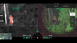
I can't seem to get my IR camera below 2x. I see your moving out to 1x. in video. What am I missing that I can't go below 2x?
Notice the zoom indicator in the top middle of the screen says 2x. The slide indicator is for the main zoom camera. The IR is upsized from the base image to the match the 1080p(on the controller screen) image of the visible camera. If you download IR images to the controller, you can see how small they are on the controller image viewer, for comparison.
@@STRThermal Okay, Thanks for the info and fast reply
6:20 - what are the purple and blue diamonds appearing on the screen when you pan around?
Those are pinpoints I’ve dropped at other locations. Pinpoint How-To for DJI Pilot 2 - DJI Mavic 3T 3E 3M Drone
ruclips.net/video/0nVvJwd2iFU/видео.html
Any info on how to download videos photos to your phone on the 3T, I’m struggling.
Thanks
You can use One Drive, Google Drive, or other file sharing app installed on the controller and phone. Is video shows One Drive. DJI RC Pro and RC Plus - Transfer or Sharing Files Wireless Method
ruclips.net/video/OMWCyDcIYfs/видео.html
Great video, would these Mavic 3T settings transfer over to the M30T? thanks and keep them coming. Why did you choose the 3T over the M30T. thanks. i'm looking to get into thermal drones and looking at a M30T right now. Haven't pulled the trigger yet. thanks again
Hey Mike, glad it was helpful to you. Most settings will apply to the M30T. The temperature range(high/low gain) and color palettes for instance.
Here is another video that should be helpful in your decision making. Ultimately I did not think the extra features(zoom and IP rating being the ones that really matter) justified the extra cost(for me). I also looked at it from a payback(revenue versus investment) perspective and even considered that the influx of deer recovery across the US could affect the stat regulations. So, I chose to start with the M3T. I am in no way disappointed.
ruclips.net/video/e1siLzzIgoc/видео.htmlsi=ODLGdEW2tANZWopO
I've never gotten mine to go to a 1x zoom on the thermal. I even just tried to do it with link zoom
I think this has to do with the difference in resolutions, the feed from the drone to controller is 1080p, the thermal is 640p. So the thermal image wouldn’t fill up the screen if shown in 1x. That said, 2x on thermal looks like you are actually closer to the ground then 1x in the wide(zoom) camera. But I think the intent is that the thermal image fills up the controller screen. If you download and review images from the drone(set CVI to get all three variants) it may make more sense. This is my own understanding but I haven’t researched it past what I’ve shared here.
Something ive noticed is when you click Link Zoom the difference between them will be locked. When it first starts / boots up the default is 7X. So when you switch between Thermal and Zoom it will jump to that 7X. Which could be useful as long as you know that. Thus saving time zooming all the way in i suppose.
But as STRT said the Thermal is locked to 2X to fit the screen.
I personally zoom all the way back to 1X before i Lock Zoom. But if seconds count i suppose leaving it locked to 7X could save time over the duration of a full flight. It just seems more appealing to the eye for video to me. For people watching a video zooming in seems more appealing, i think. But for SAR leaving it at the default 7X might be the best option.
How to record an image from the controller so that you can see the settings etc.?
A “screenshot”, back button + photo shutter button, will take an image of exactly what you see on the controller. Likewise, a “screen recording”, back button + record, will take a video of what you see on the screen and will include Audio from the internal mic.
Anyone have a tutorial for this on a 2 advanced? Need to set it for missing dog search
I don't have a M2EA, but I know it has a high and low gain mode based on notes in the manual....the manual does not instruct how to change between the modes. I suspect you would find these in either the camera three bars menu, the main three-dots menu, or the palette menu.
Ok, I'm new to this, can you explain the difference between raw recording and screen recording and how to get them ?
Download the RC pro manual. So you have your video record and photo buttons on the front/top of the controller. Those will record the images or videos on the drone(dcim folder on the sd card) in full res(according to each camera’s capability). When you hold the back button AND click the record/photo button, you get a screen recording or screenshot. Those will save on the controller(Files app, Internal Storage/Movies and Internal Storage/Pictures/screenshots folders)
What kind of daytime temperatures are you able to work through for mammal location? I'm in Australia and will be using these for Koala surveys, so obviously smaller animals than Deer, and it gets hot here so the usable window of the day temperature wise is a peak consideration of mine.
I'd really appreciate a response, and how much does the temperature range adjustment allow for making it usable during hotter periods?
How hot was this day? Was it a 90f day? THANKS!
Hey Gunnar, Koala surveys is a cool usage of the M3T. This video was filmed around June 10 and we had high temps during the day of about 90-92F and sunny. I filmed this and my SAR workflow video on the same day around 1 hrs or so before sunset and from watching the video there may have been some clouds on the horizon helping conditions. The issues with flying while the sun is up is that the suns energy quickly throws off your thermal picture due to the way every object is heated by the sun or reflects the suns energy. Bright sunlight can quickly make your trees light up and your koalas disappear(blend in). We always recommend doing any thermal work while the sun is low(late evening, early morning, or at night) or on cloudy/overcast days. I do deer surveys on, preferably, an overcast day because I want to know the daylight bedding locations. We do carcass searches in late evening or during the dark(working in daylight can prevent your need for a spotlight). But most of my videos are shot in the light just prior to sunset for best thermal results. With practice you’ll understand the times that work better for you.
@@STRThermal Thanks for your response. I just purchased a M3T and look forward to testing it here in AUS. Take care.
@@gunnar4554 I have lot of videos that apply to what you do. But if you have specific questions, you’ll find my email on the channel homepage. Dont hesitate to reach out.
When a person is first starting out, never flown a drone, do you apply for part 107 first or buy a drone first?
You will only need the part 107 if you will be flying for business purposes in the national airspace. If you are flying purely for recreation, you don't. Recreational flyers still need to pass the TRUST exam. Additionally, recreational drones above 250 grams need to registered with the FAA. Visit the FAA Drone Zone for the details. faadronezone-access.faa.gov/#/
Part 107 is required if you use a sUAV for monetary gain.
For hobby / recreational use, take the simple free online TRUST course to obtain that certificate.
Keep educating yourself and stay informed on the subject.
Just to clarify, monetary gain is not the key (although often times it is) to needing part 107. If it is not recreational, you need part 107. Example, if you create a video for a realtor and don't charge for it, that is not by definition recreational flying and requires a Part 107@@markbailey7519
Yes. That video footage would require the pilot to be certified, as the relator would be using it for its business purposes.
@@billweis4112 You are correct.
How well does it work trying to find one bedded down in the woods during the fall ?
The primary issue is the tree canopy. Sometimes I can see the heat signature on the thermal and not be able to find a large enough break in the canopy to put eyes on the deer. But all depends on what you're searching in.
@@STRThermal so if most the leaves have fallen it’s fine ? I have one showing up Saturday
@@deadwater87 Definitey, I just mean in the absolute thickest hardwoods with leaves still on.
@@STRThermal perfect ! Thank you . I’ll bug you some more when I get mine up in the and have some questions 😂
Yea probably should have ya to check up the hollee to the right.. did u scan that just flying in or out?
What do you mean?
Sorry I copied and pasted wrong thing. Lol I was wondering how to set the alarm on when something on the screen is in a certain temperature range
@@tdr.deerdrone In thermal view, drag your finger like your making a box and the box will appear. Click the bell icon to turn on the temp alert. This will alert when the temp is over your setting. Otherwise the box shows the coldest and hottest pixel. Isotherms(can turn this on/off from the palette menu) is another method for limiting the temp response of the sensor but for deer I would not suggest it…it could hurt more than help.
@@STRThermal why is that? At what temperature would you set it?
I don't use either feature. I feel like everything pops well enough purely by visual indication on the screen.
Thx!!
Thanks!
Definitely helpful and well explained. Have had mine for about a week now getting ready to take it to the lease. Really appreciate it.
Thanks so much!
Aaaaaaaaand, still no real-time GPS lat/long readout. Still have to putz around with taking a still then looking at the geo stamp in the file info...DUMB! Nothing like making a rescue crew jump backwards through their butt to get a lat/long.
@@ernieschatz3783 Actually you can have GPS coordinates showing on the screen. I’m not looking at it right now but in the on screen camera menu you can turn on “timestamp” I think it is and select what shows up in the timestamp. You can also move it where you want it I think. This is helpful so your screen recordings or drone side recordings will always show this info. I can double check the instructions when I get home. You can also drop a pin and look at the pin coordinates. You can share those coordinates(a Google maps link actually) with the share icon….this was an added feature after making this video.
@@STRThermal Very nice! I remember watching a demo video several years ago where a search and rescue guy was demonstrating how to get the lat/long from a Mavic 2 Enterprise and it involved downloading the image file and getting GPS info from the file metadata. Horribly inefficient method when time is of the essence
That sounds terrible lol. So from any camera view, click the “slider” menu button, then the three dots, then turn “timestamp” on, once timestamp is on, you can select “customize timestamp”, from there you can select what you want(aircraft info, date, time, coordinates+altitude, custom text, and timestamp location on the screen).
That sounds terrible lol. So from any camera view, click the “slider” menu button at the right top of the camera view, then the three dots, then turn “timestamp” on, once timestamp is on, you can select “customize timestamp”, from there you can select what you want(aircraft info, date, time, coordinates+altitude, custom text, and timestamp location on the screen).
Another thing, if you review an old flight record, you can see the coordinates at any given point and also use the pin icon(lower left of the screen) to pin a location in the flight path(your flight path may show that you hovered and circle a certain spot for instance). The pins made in this view will be named for the flight record file name and the timestamp of the aircraft location.
If you want to be a deer recovery drone pilot or are just looking for a thermal drone, get your DJI Mavic 3T or Matrice 30T at...
thermalhunting.com/collections/thermal-drones
Tell them Savage Tactical Recon sent you!
Can you overlay thermal image over normal image and zoom both together? If so what zoom distance?
I assume you mean like the older Mavic 2 Enterprise(the Dual did this, I am not sure about the Advanced). The Mavic 3 does not do the overlay. But you can use side by side(the SBS button in the top right of your screen) which shows the thermal on one side of the screen and the zoom on the other. I'm not looking at my controls, but you may have to select link zoom(looks like two rings linked together in the top right when in the thermal view) before you get the SBS selection. I personally don't use the side by side as I don't like the waste of screen space, but I think it can be helpful for new thermal pilots to gain spatial awareness when in the thermal view. Hope that helps and answered your question.
Good video 👍
Thanks 👍