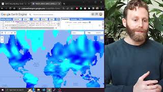
How to use GRACE and Earth Engine to look at changes in terrestrial water storage for a region

HTML-код
- Опубликовано: 3 окт 2024
- We demonstrate using GRACE and Earth Engine to look at time series of changes in water storage, for the examples of Austria and Saudi Arabia.
Script: code.earthengi...


![NOSFERATU - Official Trailer [HD] - Only In Theaters December 25](http://i.ytimg.com/vi/nulvWqYUM8k/mqdefault.jpg)

Thank you Smilovic, It is a very helpful video for regional-scale water resource assessment in any region.
Awesome, glad it is helpful 💧
❤ this was great! Thanks for sharing. Unfortunate to see such a clear decline in Saudi!
Thanks a lot !!!! I have a similar script that I developed but this one is simpler and better. Thank you for sharing.
My pleasure; glad these videos are helpful. If you have any updates or suggestions for the scripts, let me know and we can include them 😎
fantastic Mika, very helpful as usual thanks a lot
Awesome, glad it was helpful 💙
Thank you! this guide is amazing
Awesome 🤍
amazing. I learn alot from your videos.
Thanks DEAR ... great job and it is very much helpful.
Awesome to hear. What area are you looking at?
Love it Thank you so much
😍
Great video. how can you download GRACE-FO data? help needed
thanks, sir it was very helpful. do we have any other options to calculate it for 2022?
Welldone
Please go ahead to study area completely.
Very help video. I would to know can this applies for small catchments instead of a country?
Glad the video is helpful 💧 This also works for catchments (or any region) by uploading the shape file for the catchment. There is the suggestion that GRACE is most appropriate for regions bigger than 200,000 km2 (doi.org/10.1029/2009WR008564), but is worth experimenting with.
is IWE_THICKNESS and TWS are same? if not then how to calculate it from GRACE?
How to download the grace water change data in grid point wise
Very helpful video. Thank you. Could you please share the scripts with us?
Great that it was helpful! the script is now included in the video description
@@MikhailSmilovic I really appreciate it.
Is it possible to reach water storage anomalies after 2017 via Earth Engine?
Nice video how to use Grace FO?
I am not sure the anomaly of TWS could be called as change of terrestrial water storage... the anomaly is the difference compare to the baseline.
Change here is meant as the difference relative to 2004-2010
How to extract TWS in the specific location, not for the whole area but in the specific longitude and latitude
Yes same ?
Wow
If we want data from 2017 to 2021 can I able to get that from any other source
how can we get data after 2017??
Hi sir can you help me that who to apply the same procedure in rivers by preparing own river shp file
Shapefiles for river watersheds of all sizes (levels 1-12) globally are available here: www.hydrosheds.org/products/hydrobasins
These are without names, however. Using GIS software (QGIS or ArcGIS) one can select the specific river basin of interest and export this as a shape file.
Let me know how it goes!
Thank you sir
Thanks, bro, I want to ask you when I run and the console change into yellow, instead of showing the line graph, it says, line3 dataset is not defined (equivalentWaterThicknessCsr = dataset.select('lwe_thickness_csr'), what can I do.
Guten Tag, does the script shared in the video description work for you?
Thanks a lot bruv ❤ Im also started to do some lessons but in Russian. We have lack of GIS knowledges based on cloud services (GEE). Keep doing what you do 🎉
Best regards,
Akbulat
My pleasure; glad these videos are helpful 😎 I'm looking forward to seeing your videos!
Bonjour Monsieur, Puis je avoir votre email? je travail sur les images GRACE et j ai bessoin de votre appuis. Merci