Using contours to identify landforms

HTML-код
- Опубликовано: 8 сен 2024
- Grade 11 Geography:
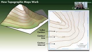
Contour lines are imaginary lines drawn on a topographic map that join places that with the same altitude. These lines show us the height, size, shape and steepness of landscape features.
Subscribe to Edukite Learning:
/ @edukitelearning
#Geography #Grade11 #topographic
#maps #contours #EdukiteLearning #edukite #SouthAfrica #CAPS #FET
#concave #slope #Convexslopes


Extremely helpful for my geography project! Thank you 😊
Loved the animations associated with the description, made it easily clear to understand. Sbonge.
Help full thanks so much 👏👏
this was really helpful thank you!!!
Wow thank you so much
hello, thanks for great representation. I need to know what is the software used to show these beautiful drawings
❤❤❤
Good
I want to learn how to make these videos
Please help me
CIS Raid
Cis raid
Cis raid
RAID OP GUYS
HEELO FREIND CHAI PILOO
CIS Raid