Global Mapper Coordinate Converter | Latitude and Longitude to UTM using Global Mapper

HTML-код
- Опубликовано: 12 сен 2024
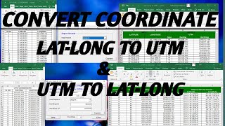
- Global Mapper is a popular GIS (Geographic Information System) software that offers a wide range of geospatial data processing and analysis capabilities, including coordinate conversion. Here are the steps to convert latitude and longitude to UTM in Global Mapper:
Open Global Mapper: Launch Global Mapper on your computer.
Load Your Data: Import the dataset that contains the latitude and longitude coordinates you want to convert. This could be a shapefile, a GPS track, or any other supported geospatial format.
Select the Data: In the Overlay Control Center (usually on the right side of the application), select the layer or dataset containing the coordinates you want to convert.
Display the Data: Make sure the data is displayed on the map view.
Convert Coordinates:
Click on the "Tools" menu.
Select "Control Center and Toolbar Options."
In the "Control Center and Toolbar Options" dialog, go to the "Coordinate Conversion" tab.
Choose Input and Output Coordinate Systems:
In the "Coordinate Conversion" tab, choose the input coordinate system (likely Geographic WGS 1984 for latitude and longitude).
For the output coordinate system, select the UTM zone that corresponds to your location. You may need to know the UTM zone number for your area.
Convert Coordinates: Once you've set the input and output coordinate systems, click the "Convert" button. This will convert the selected latitude and longitude coordinates to UTM coordinates and display them in the software.
Export Data: If you want to save the UTM coordinates to a file, you can do so by exporting the data. Click on the "File" menu, select "Export Vector Data," and choose the format and location for the exported data.


![[DOKKAN BATTLE] Worldwide Campaign Announcement Video Part 2!](http://i.ytimg.com/vi/JpT5Voak6WA/mqdefault.jpg)


Hello. Please how can I get this software?