Here's how to turn regular old polygons into charming illustrated storybook lands! I'll use symbol layers...and lots of them...in ArcGIS Pro to build up a cartoon style appearance that you can use for your nex map that needs some illustration life breathed into it. That cartoon John Nelson was drawn by Warren Davison! twitter.com/WarrenDz Project Linework data can be found here: www.projectlinework.org/
Absolutely wonderful. Your giggle after stippling made me LOL. Idea, introduce symbol layer naming so you don’t lose track of what you were trying to do.
¡Ah, es genial escucharlo! ¡Me alegro mucho de que lo hayas probado! Sí, este efecto puede llevar mucho tiempo, pero espero que te hayas divertido y que te resulte útil en el futuro.
This one is a beauty! Your work is always so high quality, I have a feeling that soon to have a chance at placing in the UC map gallery your visuals will be a requirement!
I wonder do you just randomly film your workflow... Or you have pushed all possible symbology settings already and you know exactly where and how to get to the idea?
i'll only make a video if i'm pretty sure of the result and have tried (stumbled on) a technique already. often they are the result of a question someone asks and it's just easier to show them.
Hi John! I love your videos. How would I go about adding rivers, lakes, and other water bodies while retaining all of our effects? I would love to see a part two of this where it's at the scale of a town, showing some human geography as well in this storybook style! Thanks for making these awesome videos.
From the blue coastal waters portion onwards I am getting drastically different results than in the tutorial. When setting the blue coastal glow, my coastal glow has spikes" of blue shooting outwards around the islands and harsh "buffers" of blue... My tufty turf affect also appears to be more like a million circle buffers around the coast instead of a slightly darker green glowing edge
Try setting the method to “round” if it isn’t already. Also, the simpler and smoother the polygon the better. Highly complex polygons might result in unfortunate artifacts like this. I use the small scale polygons from projectlinework.org
You might like this style: esri-styles.maps.arcgis.com/home/gallery.html?view=grid&sortOrder=desc&sortField=relevance&searchTerm=John+Nelson&showFilters=false
Thank you, John! Another amazing video. Quick question, what is the practical difference between HSL and HSV. I tend to use HSL, but am curious as to your opinion on the cartographic advantage/preference of HSV over HSL.
i don't have a good or well-considered reason for liking HSV, it just tends to work best for me. HSV and HSL are very similar. and both are miles better than RGB!
Adding the blue costal water glow and the tufty turf effect... my GIS will not add it. Even though I can see it in the preview pane! There is a lock on the right of anything I make gradient. Does this mean my ArcGIS Pro does not have the permission? But, you also have these locks... Please help! What am I doing wrong!?
hmm weird! sorry for the inconvenience. i don't know what that could be. feel free to email me with info about what version you are using and some screenshots and i'll take a look. john underscore nelson at esri dot com
Longer video that I have thoroughly enjoyed, just like all other ones! I don't maps like that often enough and it is a great joy to see how you create all those great details. Did you consider writing a (short) blog post about layers from ArcGIS Online and Living Atlas you use often? I remember some but there are too many of you videos to go through and note them down.

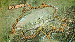


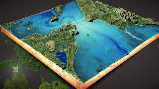


Here's how to turn regular old polygons into charming illustrated storybook lands! I'll use symbol layers...and lots of them...in ArcGIS Pro to build up a cartoon style appearance that you can use for your nex map that needs some illustration life breathed into it.
That cartoon John Nelson was drawn by Warren Davison! twitter.com/WarrenDz
Project Linework data can be found here: www.projectlinework.org/
The Bob Ross of cartography. Amazing work yet again!
Ha, thanks!
Came here to make this same comment. You beat me to it. So great to watch him work.
@@LinkElmore thanks!
@@LinkElmore we all had the same thought :D
I absolutely love watching you go full "It goes to 11" on the geeky joy. It genuinely makes my day, and the results are beautiful!
Thanks!
Nicely done.
thanks!
No matter how rough things are, when I see a JN video I get a smile! I'm always learning and being inspired to try new things. Great vid as always!
thank you, Ethen. i sure appreciate your kindness and am honored.
clever software! clever creation! clever video! love it
Thank you!
I read the blog and watched your video, then just came to tell you that I reallllllly enjoyed watching your video. Inspiring!
thank you Hala!
Absolutely wonderful. Your giggle after stippling made me LOL. Idea, introduce symbol layer naming so you don’t lose track of what you were trying to do.
ha, thanks! naming symbol layers is a GREAT feature idea!
Hue Saturation Value (HSV) for the win! Thanks for the entertaining and practical education!
Thanks!
sheer beauty and highly instructive as well. May also qualify as meditation due to the music 🧘🧘♂🧘♀
thanks!
Ummmm this is actually pretty amazing. Awesome work.
Thanks Joshua!
LOVE LOVE LOVE THIS!!!
hey thanks!
You've made a work of art out of that map
Hey thanks!
Que trabajo extraordinario! Me llevó una hora hacerlo, agotador, pero queda fantástico! Gracias Jhon!
¡Ah, es genial escucharlo! ¡Me alegro mucho de que lo hayas probado! Sí, este efecto puede llevar mucho tiempo, pero espero que te hayas divertido y que te resulte útil en el futuro.
Cool.
thank you!
How inspiring! This makes me want to get creative with my maps!
that's fantastic to hear, thanks!
This one is a beauty! Your work is always so high quality, I have a feeling that soon to have a chance at placing in the UC map gallery your visuals will be a requirement!
very kind of you, Steve, thanks!
I wonder do you just randomly film your workflow... Or you have pushed all possible symbology settings already and you know exactly where and how to get to the idea?
i'll only make a video if i'm pretty sure of the result and have tried (stumbled on) a technique already. often they are the result of a question someone asks and it's just easier to show them.
Hi John! I love your videos. How would I go about adding rivers, lakes, and other water bodies while retaining all of our effects? I would love to see a part two of this where it's at the scale of a town, showing some human geography as well in this storybook style! Thanks for making these awesome videos.
that's a great idea, thanks Alexa!
From the blue coastal waters portion onwards I am getting drastically different results than in the tutorial. When setting the blue coastal glow, my coastal glow has
spikes" of blue shooting outwards around the islands and harsh "buffers" of blue... My tufty turf affect also appears to be more like a million circle buffers around the coast instead of a slightly darker green glowing edge
Try setting the method to “round” if it isn’t already. Also, the simpler and smoother the polygon the better. Highly complex polygons might result in unfortunate artifacts like this. I use the small scale polygons from projectlinework.org
17:53 lmao well done John
thanks!
I have been working on a lord of the rings style map and the crinkled paper texture seems perfect!
You might like this style: esri-styles.maps.arcgis.com/home/gallery.html?view=grid&sortOrder=desc&sortField=relevance&searchTerm=John+Nelson&showFilters=false
Thank you, John! Another amazing video. Quick question, what is the practical difference between HSL and HSV. I tend to use HSL, but am curious as to your opinion on the cartographic advantage/preference of HSV over HSL.
i don't have a good or well-considered reason for liking HSV, it just tends to work best for me. HSV and HSL are very similar. and both are miles better than RGB!
@@JohnNelsonMaps Using RGB is like being in an abusive relationship.
@@jonathancampbell1197 to me it’s like a blanket that’s too short.
Adding the blue costal water glow and the tufty turf effect... my GIS will not add it. Even though I can see it in the preview pane!
There is a lock on the right of anything I make gradient. Does this mean my ArcGIS Pro does not have the permission? But, you also have these locks...
Please help! What am I doing wrong!?
hmm weird! sorry for the inconvenience. i don't know what that could be. feel free to email me with info about what version you are using and some screenshots and i'll take a look. john underscore nelson at esri dot com
Longer video that I have thoroughly enjoyed, just like all other ones! I don't maps like that often enough and it is a great joy to see how you create all those great details. Did you consider writing a (short) blog post about layers from ArcGIS Online and Living Atlas you use often? I remember some but there are too many of you videos to go through and note them down.
thanks Zorko! that's a good idea.