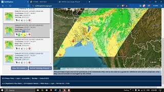
How to Download Resourcesat2 LISS 4 satellite data from Bhoonidhi

HTML-код
- Опубликовано: 22 фев 2024
- Any Help Contact
Mr.Vikas Ghadamode--Vikasghadamode77@gmail.com
WhatsApp Number: +918421031398
WhatsApp Chat:wa.me/+918421031398
Geotech GIS Training Institute is a prestigious remote sensing training institute in India. Our vision is to bring an opportunity to every aspirant who dreams of a successful remote sensing and GIS career.
We conduct the following courses:
Training Program Related to Project Work- Duration- 1 Month
Basics of Remote Sensing and GIS - Duration- 3 Months
Advance Diploma in Remote Sensing and GIS - Duration- 6 Months
PG Diploma in Remote Sensing and GIS- Duration- 1 Year
Master of Remote Sensing and GIS - Duration: 2 Years
You May Like
How to Delineate Watershed using DEM data in ArcGIS Pro: • How to Delineate Water...
What is Projection
ArcGIS Lesson-1 Arcgis for beginners, Introduction of GIS, Georeferencing and Projection: • ArcGIS Lesson-1 Arcgis...
Population Density Data: www.census2011.co.in/census/s...
Diva GIS Shapefile: www.diva-gis.org/gdata
RS & GIS QA15- Download ready-to-use contour lines from Open DEM & Generate DEM from Contour: • RS & GIS QA15- Downloa...
Land Use Land Cover Mapping in QGIS: • Land Use Land Cove (LU...
How to Download Landsat 9 Data set from USGS Earth Explorer: • How to Download Landsa...
Download Rainfall data: • Download rainfall data...
Google earth Playlist: • Google Earth Hands On
ArcGIS: • ARC GIS
QGIS: • QGIS Lesson


![[ GUILTY GEAR STRIVE: DUAL RULERS ] Teaser Trailer](http://i.ytimg.com/vi/e4TDqaE3XAg/mqdefault.jpg)


Sir can we extract DN or cell values in composit raster...if yes then how... please either explain or make a video on it ... thanks in advance
sir how we can soil moisture process video plz sir
Can you make video to download cadastral map from bhu naksha or anywhere .plz I need to download 🙏
Sir how we can download ortho
And make video on making mxd
we can do the superwise & Unsuperwise classification through that type file
Yes you can do classification on this image
bhaia downloading k time product not online dikha rahe kya karna chahia , har ak tiles me same dikha rahe hain.
Which one is better for LULC map Landsat or liss data for hilly areas.
LISS 4 is good because it is high resolution
@@vikasghadamode Thanks sir ,
sir make a video on soil erosion in ArcGIS
Sure if time permits i will prepare
Error 412 show kr rha h
Konse steps me error aa raha hai
i am facing issues in registration
What issue you are facing while registeration
@@vikasghadamode thanks for the reply sir it was temporary issue, when I used another system it has been done 👍.