Forecast Discussion - April 25, 2024 - Potential Severe Weather Outbreak Sequence Begins Today

HTML-код
- Опубликовано: 2 июн 2024
- For educational purposes only. If you live in the affected areas, please stay tuned to your local National Weather Service office for the most accurate and up-to-date information.
Our well-advertised mutli-day severe weather sequence is set to begin today (Thursday, April 25) as a series of troughs takes aim at a moist airmass draped across the Plains.
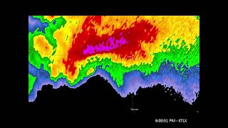
TODAY (THURSDAY): Supercells will likely fire ahead of a deepening surface low and tightening dryline across western Kansas and in an upslope regime in northeast Colorado this afternoon, where SPC has outlined an Enhanced Risk (level 3/5). Initially, these storms will be capable of producing large to very large hail; the (strong) tornado threat will ramp up by early evening with any sustained discrete supercells that can remain within the warm sector. Farther south along the dryline, supercell development is more conditional but could foster a significant severe threat should any develop. An additional batch of severe storms should fire late tonight across northwest Texas and southwest Oklahoma, posing an all-hazards threat. Here, SPC has also outlined an Enhanced Risk (level 3/5).
FRIDAY: SPC has outlined an Enhanced Risk (level 3/5) centered on the confluence of Nebraska, Iowa, Missouri, and Kansas. An arc of supercells is expected ahead of the surface low here; given strong instability and low-level shear, a strong tornado or two is possible, along with very large hail and damaging winds. A more conditional all-hazards threat exists farther south along the dryline.
SATURDAY/SUNDAY: Potential exists for a significant severe weather outbreak on Saturday focused on Kansas and Oklahoma, where SPC has outlined an Enhanced Risk (level 3/5). A second potent trough will move in and interact with a broad warm sector featuring rich low-level moisture. Intense kinematics may foster a strong/long-track tornado threat, contingent on the degree of morning convection. The threat will shift east on Sunday, but we won't know about Sunday until we see how Saturday plays out.
Become a Patreon member today to support the channel: / convectivechronicles
Facebook: / convectivechronicles
X: / convchronicles
Instagram: / convectivechronicles
Contents
0:00 Introduction, risk areas
4:07 Discussion of today's setup
32:09 Discussion of Friday's setup
40:41 Discussion of Saturday/Sunday setup
48:36 Wrap-up  Наука
Наука


On another note, thank you for not using cringe “THIS IS GOING TO BE REALLY BAD!!!!” clickbait thumbnails. You’re a true professional.
I know. Ryan Hall was the one who started doing it, and now every weather RUclipsr, who's trying to mimic his success, is doing it too.
That’s marketing. That’s how RUclips works. Grow up
Trey has the soul of an old professor 😂 he's very scholarly in his approach 😁
@@nagitokomaeda4089 i feel like when youre dealing with a subject that already induces extreme panic and anxiety in people (and not for no reason; this stuff changes lives), you're obligated to present the information in a responsible manner. that extends to your thumbnails.
@@nagitokomaeda4089 Wow, that's unnecessarily hostile. Chill out.
If nobody got me, I know convective chronicles got me
fr
Fr fr
I’m a college student in Abilene who’s been trying supercell photography for a couple of years. Still haven’t got a tornado yet. Fingers crossed this is the weekend.
That’s awesome! I’m a videographer/photographer/editor for my job and I’ve always wanted to get into storm photography. You should comment on Trey’s next video updating us on if you get a tornado!
Good luck to ya! Happy chasing, my friend.
Oh good, it's not just me struggling to get good tornado photos. Hope this weekend treats you well, with no tornadic induced casualties besides the crickets in the fields!
I mean yea photography is great and all but make sure to to keep your fingers crossed that your tornado you spot doesn't hit any houses😅
@@Big_threegodsright like peoples houses get destroyed in tornados and they’re worried about photography like what
Thanks Trey, great as always. Its nice to hear a weather tuber use reason and objective data instead of hyping the living crap out of every single forecast.
Thank you! The hypecasting gets so old, so I’ve always tried to stick to objective analysis in my videos.
I have been walking around with my phone in hand waiting for the notification from you Trey. Thanks for updating us with the latest updates on this upcoming severe weather outbreak. Be safe if you’re out chasing. Also please upload some of your chases! I would love to see more of them. Thanks for sharing your knowledge with us. I feel smarter after every video ❤
Thank you! Chasing up in Kansas today; hoping for some nice open field tornadoes. I have another channel for my chasing footage called MadWX Chasing (I believe I have it on the bottom of my main channel page under “Featured Channels”.
Trey is everywhere recording videos, wouldn't be surprised one day your on a mountain recording one, in the middle of the Atlantic with a hygrometer measuring weather potential, maybe one day in space for a forecast discussion!
That would be sweet!
Always a good morning with a Convective Chronical upload! Working to offset my disappointment with the NW Oklahoma setup right up 😅
I live in Southeastern Nebraska. I do have a plan in case a Destructive Tornado is barring down on my area since I live in an apartment
Best channel for weather HANDS DOWN
Thank you so much!
Quite the set ups! Seems like everything is conditional yet again! Great video!
Thank you! Definitely one of the more potent stretches we’ve seen in awhile!
Thanks, Trey, for taking time out of your morning to bring us this new information.
Gonna be glued to your analysis and discussions thru Sunday lol. Really intrigued to see how Saturday plays out because it definitely could be a higher end type day. Thanks for the vid as always Trey!!
Thank you Mr. Trey for another excellent video / we are expecting in Tulsa by Monday to have a total of 6 to 8 inches of rain // there was heavy rain in the middle of the night so I guess the ground is beginning to be saturated / thanks again for making me feel more at ease with this next four days
Thank you!
Lets go!! Highly anticipated upload right here
Heavenly Father, In the face of severe storms and inclement weather, we come before You, seeking Your divine protection.
You are the One who calms the raging seas and stills the storm.
Shield us from the dangers that this weather brings, safeguarding our lives, homes, and communities.
Grant wisdom to meteorologists and emergency responders as they provide guidance and assistance.
May Your peace and assurance prevail over fear and anxiety.
In Jesus’ name, we pray.
Amen. 🙏✝️
Activly on the road traveling and STILL put out professional videos! You even knew how to share screens! (sorry that was a low blow to the NWS lol).
Severe weather waits for nobody, so I always try to get vids out when I’m able for big days!
Crazy stuff coming up, thank you Trey!
I just need to tell you thank you so much for not talking fast like a carpetbagging salesman. Love channel owners who are chill, clear and concise.
Haha thank you!
Been refreshing since yesterday waiting for this one 😂
So I'm not the only one😂
Thanks, and good luck on the chase.
Thank you!
I'm keeping my eye on things in Olathe and the adjacent area.
Very dependable weather channel
the most concerning thing i noticed about Saturday is its comparing it to April 3 1974 at 18z where peak activity started
Yeah, Saturday certainly has a high ceiling
I really appreciate your professionalism. It keeps me coming back
Thank you!
Thank youuuu!!!!! I was urgently waiting for this vid to drop!!!!! Keep it uppp
I think even people in southeast South Dakota as well as southwest, central, east-central, and southeast Minnesota should watch this setup very closely.
As always... thanks Trey. You are the best on RUclips... period.
Thank you so much!
Thanks for the analysis as always Trey! Good luck chasing and be safe!
Thank you!!
TY for the update!
Thanks
Great video Trey thanks for sharing your thoughts on this!!!!
Thank you!
@@ConvectiveChronicles your welcome 😁
About time Trey! You've become our local weather man!
Wasn't expecting to see a WOWSL creator here lmao
Thank you Trey! Excited to chase with my wife this weekend!
Nice! Be safe and best of luck!
@@ConvectiveChronicles Thanks! Same to you. Good luck out there.
Have you ever done a video on April 6-8 2006 outbreak? Only time I've ever seen 60% Tornado on the convective outlook.
It’s on my list!
@ConvectiveChronicles Awesome. Looking forward to it!
Great update Trey! Seems like Saturday is dependent on early convection.
Thank you! I'm not as concerned with early convection as I was earlier, but more so a more unfavorable storm mode.
Interesting to see how things have changed just over the last few hours. Thanks for taking the time to put this video out and happy chasing!
Thank you! This is definitely a rapidly revolving setup, which are always tricky to forecast.
As long as all this continues to stay away from the TC metro I'll be fine.
44:01 Those sounding analogues for April 3 and April 4, 1974, yikes. Right near where I live. Will be watching the next couple videos very closely.
Thanks Trey, these are always so fun to watch. Good luck in the plains this weekend!
Unrelated, but how do you get your mouse to draw as if it were a sharpie? I've always been curious.
Thank you! I use a Wacom Intuos Tablet and a Mac app called Presentify to write on the screen.
@@ConvectiveChronicles Aha! Thanks for sharing. Have fun this weekend!
Delayed again, lol. Such is life👍
Today might be quite conditional but Saturday is looking pretty potent
@@ConvectiveChroniclesI agree. Saturday looks bad.
I’ll be quite surprised if they don’t upgrade Saturday’s outlook to moderate by 12z day of. I expect they’ll update the tornado threat to a 15% hatched.
Yeah, if they can get a little more confidence on an unsullied warm sector, then an update is certainly possible
@@ConvectiveChroniclesIndeed. We’ll have to see what the CAMs show a bit closer to the day.
Southwest Wisconsin is looking SPICY Saturday. Is that an accurate statement?
Certainly could see an all hazards threat there
I’m very happy I chose not to drive 7 hours north today. Almost did. Starting to lose confidence.
Yeah, today was awful from a chase perspective
Do you think a drive out to north east colorado is worth it today? Would leave at about 3pm here and im about 2 hours away from Akron/Fort Morgan area
Yes, definitely
What are your thoughts on rain chances lessening for the 10% risk area, mainly Kansas has gone down to a 30%
What day?
Also I got really bad flash flooding at my house this morning with a really big thunderstorm that had Alot of lightning
Dang!
@@ConvectiveChronicles yeah it got intense but I know this isn't the main event with this storm system at the same time
Its crazy the area that saturdays risk has! So far! Ugh im in the hatched area of saturdays event 😞
Yeah, Saturday looks to be potent if everything comes together. Definitely keep an eye out!
I'm almost in it will be watching to see if anything changes hope you stay safe!!!
@@LeviW133 i hope that you do too!
What's got me so concerned is the analogs, 4 extremely potent tornado outbreaks as analogs included both 3rd and 4th of '74, do you really think this has the potential to be that bad??
The ceiling is certainly high
CONVECTIVE CHRONICALS POSTED 🗣️🗣️ WTF IS A BAD FORCAST 🗣️🗣️🗣️
what websites do you use?
College of DuPage (models, satellite)
Pivotal Weather
SPC (Mesoanalysis, Observed Soundings)
UCAR Surface
Could you explain the "triple point"? I'm assuming it's a triple point of converging air masses but I'm a biologist, NOT a meteorologist, lol! TY! Wonderful, in-depth forecast for the science nerds!!
Thank you! A triple point is the just the intersection point between two boundaries…in this case, it was the dryline and the warm front.
Does anybody know if Vincennes Indiana will be hit by those storms?? Im in the netherlands rite now so idk what gonna happen
I’d definitely keep an eye out Friday onward there
@@ConvectiveChroniclesOkie. Thanks mister
I can't believe I'm rooting for isolated supercells ... what has happened 🤣
Thanks Trey. Hope you weren't actually driving while making this... 😂 Be safe out there. Happy chasing 🌪
Thank you! Negative; was in the hotel parking lot…our tour van is the only relatively secluded place I can get usually, so I just record in there.
@@ConvectiveChronicles ahhhh yes that makes more sense!
Woohoo the video I’ve been patiently waiting this morning for
Nuances
Boom bet northern
Help I’m in a MRGL risk. This is only the beginning of the end. /j
Goat. Thanks for doing these. I'm in New England but severe weather has always fascinated me, especially being a pilot. Stay safe out there if/when you're chasing!
Thank you!