Geospatial Deep Learning with ArcGIS

HTML-код
- Опубликовано: 13 июл 2024
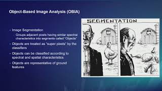
- Deep Learning is an AI technique that uses deep neural networks to solve complex problems. One area of AI where Deep Learning has done exceedingly well is computer vision, or the ability for computers to see. This makes it especially suitable for imagery tasks such as pixel classification, object detection and categorizing features. In this hands-on session, learn how deep learning can be applied on imagery in the ArcGIS platform. You will use ArcGIS Pro and the arcgis.learn module (in ArcGIS API for Python) to train Pixel based Image Classification, Object Detection, and Feature Categorization deep learning models. You will learn about deploying these models in ArcGIS Pro and scaling up inferencing using Image Server. This demo rich session with provide you an opportunity to learn from experts on - Spatial data science capabilities of the ArcGIS platform - Using ArcGIS Notebooks for reproducible and repeatable spatial data science workflows - Spatial analysis, raster analysis and big data analysis using Python - Geospatial machine learning and deep learning capabilities - Training and deploying deep learning models for Image Classification, Object Detection, Feature Extraction and Feature Categorization - Natural language processing on unstructured text - Scalable deep learning with ArcGIS Enterprise - Technology updates, tips, and tricks from Esri experts for successfully deploying and implementing AI solutions - Examples of real-world Geo-AI projects Familiarity with Python is a required prerequisite
--------------------------------------------------------------------------------------------------------------------------
Follow us on Social Media!
Twitter: / esri
Facebook: / esrigis
LinkedIn: / esri
Instagram: / esrigram
The Science of Where: www.esri.com  Наука
Наука


One of the most enlightening talks that i have seen about ArcGIS
Thank you so much for sharing !
How do you change the band selection? what is the numbering convention for the bands, 0,1,2,3 ? or 1,2,3,4?
Great talk. Amazing tools. I’m interested in PointCNN for point cloud classification.
Very cool run-through of the tools. I'm wondering how to prepare the data for pixel class classification using U-Net. Still a bit vague about it despite the notebook and documentation since the data was all prepared prior to the exercises. Is there anywhere outlining steps by steps when it comes to satellite image? Do we use a composite straight off? Do we have to change the pixel type? Do we separate the bands?
Seconding this comment! @ESRI
Excellence
Thank you🙏🏻i want to run image segmentation for walkability
What defines the tile x and tile y size? I'm trying to develop an automated pineapple count and I'm stuck in that step because I dont know what I should write
Not sure if anyone can help, but when I use the train data for deep learning tool it never gets past pending! It is driving me insane! There seems to be no help articles for this issue. Thanks
How can you access the notebook?
Can I use arcgis pro with ram 8gb on Intel i5 gen 8th?
depends on your gpu
for nvdia 960m+ would be enough