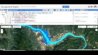
🛑 Live Earth Engine Python API in Google Colab | How to filter Satellite Imagery and make NDVI Map

HTML-код
- Опубликовано: 28 июл 2022
- 🛑 Live Earth Engine Python API in Google Colab | How to filter Satellite Imagery and make NDVI Map
Registration is open for the 'Online Training on Google Earth Engine (GEE) for Remote sensing Analysis for Beginner's, 18th Batch. Online training program Conducted by #StudyHacks (Institute of GIS & Remote sensing)
✌Take advantage of this discount and register very first!!!
✌ Register 1st 5 People to get a 50% Discount.
💻 Classes will be via Zoom on the 9th, 10th & 11th of August from 9.00 pm until 12.00 AM (BD time) or 21:00 to 00:00 (GMT+6);
Class Duration: 3 hours
👉 For booking Your Seat Contact this WhatsApp Number: +8801780942798 or Email: rmijanur10266@gmail.com
Online Training on Google Earth Engine (GEE) for Remote sensing Analysis for Beginners, 18th Batch, this class will teach you all the things you need to start using GEE for your remote sensing analysis. We mainly focus on these people who don't know any programming language and Earth Engine function. After completing this course, you are able to do any Remote sensing analysis very quickly and efficiently using the Google Earth Engine Platform. We cover LULC mapping, Air quality, Monitoring, Time series analysis, Calculating any Indices, Supervised Classification, Machine Learning Methods, and more.
Course Content:
1) Introduction to Google Earth Engine, How to create a verified Earth Engine account
2) Basic JavaScript Programming Language
3) Client VS Server Object: Earth Engine Server Function
4) Filtering visualizing satellite imagery: Landsat, Sentinel, Modis
5) Importing and Exporting Raster and Vector data
6) Making Landuse and LandCover Classification Map in GEE
7) Computation with satellite imagery: Band Calculations
8 ) Making time series Chart analysis
9) Air Quality Monitoring using sentinel-5
10)Spectral indices and develop the Skills for calculating any Index (NDVI, NDWI, NDSI, MNDWI, MSAVI, etc.)
💲 Course Fee: 350$ / 14000 INR / 10,000 BDT / 8000 Ethiopian Birr(✌Take advantage of this discount for the First 5 people can join this course 50% discount only 175$ / 7000 INR / 5000 Bangladeshi Taka / 4000 Ethiopian Birr )
👉 For booking Your Seat Contact this WhatsApp Number: +8801780942798 or Email: rmijanur10266@gmail.com
✌Take advantage of this discount and register very first!!!
👩🎓👨🎓There are already over 150+ students who have taken part in our training and courses and many are already developing their own codes and research with the GEE.
Join Our Community:
Join our official RUclips Channel: / @gisrsinstitute
Join our official Facebook Page:
/ studyhackseducationcenter
Join Telegram group: t.me/gisandremotesenginglearn...
Join What's App Group: chat.whatsapp.com/DJyR6BjhnBa...
Join Skype Group: join.skype.com/ym0c1b7bjxHH/
Join our Facebook page: / studyhackseducationcenter
Join our Instagram: / study_hacks_geoscience...
#gis #remotesensing #googleearthengine #EarthEngine


![Sean Rii, Karyon, Sharzkii - Taungule [My Love] (Official Music Video)](http://i.ytimg.com/vi/eJoMuypbSzQ/mqdefault.jpg)


well done, nice examples.
Thanks
sir😘😘😘😘😘😘😘😘😘
Thank you sir, This is Awesome work, and very easy to understand each step.
Sir if you don't mind. I have too much shapefiles of different plots. And I want to get time series ndvi mean value of each plot for now. The objective is to automatise this process, by choosing a specific date and generate ndvi for a chosen plot if it is possible.
I wanna use Sentinel-2 images because it has 10m resolution and it's important for me. Thank you sir.
Nice lecture sir.
How can one filter state shapefile in a country?
Can someone import csv files or geodatabase from arcgis into the map on google colab.
if i want to make a shapefile of a city in bagladesh and not the whole country what i need to do?
divagis.com