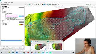
How to create Terrain from DEM in HEC_RAS 5.0.3 for 2D Flood Simulation

HTML-код
- Опубликовано: 8 фев 2025
- This video Tutorial is shown the simple procedure of how to create Terrain for Hydraulic Model HEC-RAS 2D Flood SImulation.
Hope you enjoy it.
Thumb up for the Video and Subscribe my Channel to get the update video related to Hydraulic and Hydrological Model, ArcGIS, Climate Data Operation... Thanks


OMG i have been searching how to process terrain after viewing a lot of videos including your video create 2d areafor hecras version 5.0 since one month ago. Thanks!!!
Thanks for your nice comment.
HOW TO FIND EG SLOPE IN UNSTEADY FLOW DATA For HYDROGRAPH SIR? and MUltiplier also how to find it sir
I typically estimate the EGL slope from the terrain slope in the area where the flow is expected to be most concentrated. After your first run you can look at the WSE slope in the area to see if adjustment to you initial estimate is necessary.
@@samseihauk2845 sir please tell me with clarity as I am new to this or if you have any your video let me know sir it's urgent
Good presentation sir... Could I get more detail process in making dtm/dem file... Or what type of file do you means? Thanks
Thank for your time on the Video. The DEM/DTM can be obtained freely from NASA, USGS, and other sources. The DEM used in the Video Terrain is 200x200 Resolution.
this is great man, i also have tutorials like this in hec-ras 5.0.4 on 1d-2d connection in ras mapper using profile and in geometric data using breaklines as connections
Thank you!!!!
Thank you Sam
i would like to use HEC RAS and when i try to run it gives me error
so i need help how to make input data of flow series data and using unsteady state.
i am writting thesis for flood risk and flood mapping for HEC RAS and i have problem to make input flowdata for hec ras please help me, see you soon
Hello, I will help you in Hecras 2d please contact me on my email Designnetwork87@gmail.com
hello, do you know the way to create projection file, spatial reference for specific area
Hi, you can export it from GIS program by Projection it in Data Management Tool. Best
@@samseihauk2845 thanks
hello sir i wanna ask, how if i dont have spatial refrence projection file, what should i do ?? My project is on 50s
Hi Aditya Nanta, it's no need to download from any website. You can simply make it in your GIS, when you export any shapefile of your area, the .prj file will be exported in the directory.
I am interested your video that convert Terrain from DEM in HEC_RAS. Thank you brother
why instead of showing how to do.a lot of writing fk
This was aggravating to watch.
Hi, Dr. idol 🤣🤣
i want ask something, is it problem having the dem with a large cell size?, then i want to ask how do i choose the rounding for create terrain? 1/32 1/64 1/128 what is that meaning? and what is impact to our terrain? thank you
Very bad ☹☹