Vertical Topographic Differencing of USGS 3DEP and NOAA Topography

HTML-код
- Опубликовано: 2 окт 2024
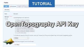
- This video demonstrates how to apply OpenTopography's on-demand vertical topographic differencing tool to USGS 3DEP and NOAA lidar topography.
opentopography...
OpenTopography facilitates community access to high-resolution, Earth science-oriented topography data and related tools and resources


![[ECCV 2024] GeoCalib: Learning Single-image Calibration with Geometric Optimization](/img/1.gif)
0:52 Please open this for private users as well. Fligt simmers all over the world would love to get use of this data as well .
Hola podrías colocar sudtitulo en tu videos y tu has hecho un papercraft de una montaña