Это видео недоступно.
Сожалеем об этом.
Lidar Processing with MATLAB

HTML-код
- Опубликовано: 14 дек 2021
- Learn how to use MATLAB to process lidar sensor data for ground, aerial and indoor lidar processing application. You will learn how to use MATLAB to:
Import and visualize live and recorded lidar data
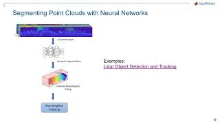
Apply deep learning to lidar data
Calibrate lidar and cameras
Track objects in lidar
Create 3-D maps and terrain maps using SLAM
Generate C/C++ and GPU Code
Highlights Include:
Lidar Labeler App: Interactive, semi-automated, and custom automated labeling of lidar point clouds
Lidar-Camera Calibration: Calibrate lidar and camera sensors to estimate cross-sensor coordinate transform
Deep Learning for Lidar Point Cloud Processing: Use deep learning networks to detect and segment objects in lidar point cloud data
Shape Fitting: Fit shape and track detected objects in a lidar point cloud sequence
Feature Matching: Extract and match lidar point cloud features
Lidar Object Tracking
Simulating Lidar Sensor Data
2-D Lidar Processing: Simulate and process 2-D laser scan data and estimate the pose between two scans
Velodyne LiDAR Streaming: Connect and stream lidar point clouds from Velodyne LiDAR sensors
Lidar File Readers: Support for Ibeo sensor, LAS, and LAZ file formats
Code generation for CPU and GPU
___________________________________________________________
Minhaj Falaki - Product Manager, MathWorks India
___________________________________________________________
לנושאים נוספים ויצירת קשר:
לאתר: www.systematic...
לאירועים נוספים: www.systematic...
לבלוג: www.systematic...
לפייסבוק: / matlabisrael
ללינקדין: / 1774805


Crystal clear macha ... Proud that ur in Matlab
can you explain the aerial SLAM in detail step by step
So even handheld processor like smartphone can do imediately lidar job with camera flash low intensity infrared and uv and white light opposist sweept for long range and ultrasound for close range sweep and aerial photograph capture sky bound signal and zoom out by camera then we could handle from 20 m to 1 km range prevention
Are these MATLAB scripts publicly available?
Tracking is overengineering cost cpu time wasted pulse is enough to know motion need no tracking