Easily the best Mt Whitney MR video I’ve seen to date. Thank you times a million for grading the climbs (class 2 vs 3 vs 4) u encountered on the way up. All the other MR videos seem to not include that crucial info. Thx again, and cheers to you
I drove by this on 395 on my way to Yosemite and said "Damn, I have to see that up close" and after watching this video I plan to do it sooner than later!!
Excellent video. For reference: The summit plaque (dating to 1930) lists the elevation as 14,496.811 ft. Over the years, the mountain has been measured multiple times in various ways, producing various results; the currently accepted figure is 14,500.8 ft. Mt Elbert (highest point in Colorado) is 14,440 ft - so just 60 ft less than Mt Whitney.
I really enjoyed following along with you on this loop. I know that most people do the Mountaineer’s route-which I’ve never attempted-in two days, camping overnight at (I believe) Boy Scout Lake, then climbing the chute the next day. I’d never imagined someone doing it as a loop (especially not being familiar with the route!), and in one day, no less. You make it look almost “easy” and straightforward; but I know you’ve gotta have solid route finding skills, be competent on Class 3 rock, and be WELL acclimatized to pull this off in such “no sweat” fashion. Bravo, and thanks for the excellent, entertaining-and informative!-documentary.
Great video log! I haven't read all 118 comments, so this may have already been covered, but... At the 22:22 point of the video, when you notice the cable railing guarding a relatively short section of trail in the middle of the "99 switchbacks" and you call the cables "absurd", your point is well-taken, except for the fact that during certain times of the year, there is water draining over this section, and it can freeze rather quickly. During two of my five ascents - also up the Mountaineers' Route and down the Whitney Trail (sometimes called the "Fisherman's Trail" or "Main Trail") - this section on the switchbacks had iced over as the temperature dropped late in the day, and the cables were absolutely necessary to safely pass without the risk of slipping and possibly falling over the edge. First time I did Whitney, conditions were perfect; and I, too, wondered what the point of the cables were. Picture the same section entirely glazed over with ice and you'll understand. Again: great video! Well done, and Thanks!
That was exciting,surprising and educational. You made it look very easy. My bet is that few people would take the mountaineer route “solo”, so kudos for the badassery.
I did that hike and many others when I was a teenager. Loved to hike but my feet fell apart. Seeing your video brought me so much joy. So many great hikes and destinations in California.
I really like this channel. I recently had a major medical scare and it woke me up. Hiking has taken the forefront in my life again. Back in the day when I was an avid hiker we didn't have the internet to find hikes and collect data. I enjoy your videos to see if I am able to do these hikes or not. Plus they are just fun to watch. Thanks man. Keep them coming.
I did this route in late Sept. of 2006 when the Mountaineer's Rt. did not require a permit. I had a permit for the main trail, so I used that to go down. There was more snow then, but this year is in a drought. I had difficulty finding a way out of the Moraine to Iceberg Lake because the ledges were still iced over. At 7:28, I took the rocky slope on the left to the minor notch in front of the shadow. The slope you took was covered in snow. The hard part for me was the scree slope just before the crest at the big notch. I took the first chute, or "final 400" to the summit, which was not difficult, but ironically, I was flummoxed at the very last 8 feet trying to get up a wall. I completed the hike in 16 hrs - 10 up and 6 down.
Next time you’re up there, you ought to tag Mt Muir, an easy short class 3 from the crest trail. It offers an outstanding view of the crest and summit block.
That was awesome man. I plan on summiting Whitney this year via mountaineers route. Another climb I’m doing this season will be Black Kaweah in Sequoia.
Looking down from the foot of Mt. Whitney to the eastern valley results in one of the highest vertical reliefs as well, unlike many of the Colorado 14ers that have a base of over 8000 feet. Well done sir!
Awesome video. I’m heading out in 2 days. Gonna do north fork to iceberg, camp, climb the east buttress (which is 5.7) then come down the mountaineers route. May camp again or head back to the car depending on how dead we feel. Thanks for sharing! I’ve watched a few of your other CO 14er vids for research. Excellent work 🤙
Hi Sherpa! Excellent video! It seems to me you always challenge yourself by taking difficult routes. In this case it is the Mountaineer’s trail in a day. This is the U.S. Army Ranger way of doing things. Rangers lead the way!
I did this exact route in May and had a near death experience in the final chute as three basketball sized rocks whizzed by my head at what seemed to be +100mph, started by something like 9:35. At that time the chute was still snowed in, except for the last ~200ft. The chute is very long, and I couldn't even see the party above me, so a callout wouldn't have mattered. I implore anyone who does this route to be super careful. Also, with snow, you have crampons on, so footing is much more secure in exposed areas like 11:40 (if you know how to walk with crampons on). People have died in that spot, so it's important to have some prior experience if you do go earlier in the season. If I had to do it again, I'd still go early season (April-May), but would've glissaded down the chute next to the 99 switchbacks on the standard route. The switchbacks were extremely exposed in areas since that face was still covered in snow.
Glad you are okay - I can 100% imagine what a dangerous situation it would be with other people in front of you - especially if they weren’t super experienced. Agree, like I touched on towards the end of the video, this route really should be done with snow for the most safety and fun.
If you are referring to the "final 400" above the notch, to the summit, I had a similar experience. Although it was not close, some hikers above me dislodged a soccer ball sized rock and yelled a warning. I was on a secure ledge and darted to the side, but the rock was far enough away not to be a threat. That chute is not a difficult climb, but definitely worthy of caution.
@@aliensoup2420 mine was actually still in the main chute, about 13,500. I was so spooked that I skipped the final 400 and went the long way around. It was also partially snow covered when I went, and I was by myself.
I believe the 5.7 route is what a friend uses. It branches off to the left of the gulley and ascends the east face. It is not that technical, but has two particularly noteworthy features. First, finding the correct route (unmarked) is difficult. One can waste a LOT of time either backtracking in search of it, or be forced into more technical ascents. Second, a key move is known as the 'Fresh Air Traverse', which entails a brief, but VERY exposed traverse.
Before it got light enough, I thought you were wearing orange micro shorts. I’m just glad light told the truth. 😂😅. Another great guide! Happy Halloween!
Wow what a hike this was such beauty!! Incredible views. Great video showcasing the beauty of great nature! Thanks for sharing! Be safe on your adventure👍👍👍
Have never been up the mountaineering route it really doesn't look that enticing. Always enjoy day hiking up the smooth and consistent standard route where you can get a pace going and move right along. Always feel good on the way down but seems to be longer down in spite of the ease. Good video.
@@TheVirtualsherpa nice! I was reading your trail guide, didn’t realize you could still get spots if you didn’t get one in the lottery. Also, I just happened to notice that it looks like the gpx recording is currently the tour de abyss one instead of the Whitney one.
@@XxxUnderestimatedxxX yeah absolutely not the only way, highly recommend just refreshing the permit page for the dates you want. Can also go starting tomorrow through May 1st as the permits are unlimited
Did the Main Mt Whitney Trail (MMWT) about 13 years ago and as a day hike it's an absolute endurance test (and really sucks on the joints by the end). Would love to get back someday to do the mountaineer route. I'd always heard it was intense and frightening so seeing this footage gave a very realistic idea of what to expect! Living in CO now there are lots of opportunities for practice, too :)
This was the most brutal hike my cousins and I did(because of poor planning). Was a year of like 200% snowfall. Hiked in June or July and everyone had legit winter hiking gear like micro spikes, ice axe, etc… and we had sticks we found. Was snow basically the whole way up. Somehow made it up and down the chute. Was wild.
Boots alone are arguably better than micro spikes on steep snow. You can kick steps with boots, micro spikes will give you a false sense of security; if you turn your ankle or start to slip with spikes they can twist right off your boots. Better still would be light crampons, there are aluminum ones out there which are super light weight and good insurance to just throw in your pack if you're unsure of the conditions. Micro spikes are really only advisable on relatively flat terrain where the main hazard is slipping on ice.
Enjoyed the video, easy watch and love footage of the sierra in just about any capacity. When you headed up from the notch, it looks like you went way past the standard way. The area you indicated was "higher class 4 or class 5" is the normal way most people go, hardest part is right as you start out of the notch if memory serves. The way you went was probably way sketchier due to the looseness.
Agree yeah - the beta I had steered me a bit off from where I wanted to climb. If you start closer to the notch, I believe there should be much more solid class 3 rock. Regardless though, I stand by my take in the video saying that this would be much more fun and safe with snow.
Witney was brutally long for me. Have you done mt rainier yet? I have climbed 30 14ers crestone peak as my hardest. I need rainer to het the top 10 highest in the lower 48. Stage 4 cancer and then corona destroyed my legs so im trying to make a comeback to climb a few more. Stay safe up there!
Well done. I enjoy all of your video work. One comment: you included Evans/Bierstaad file in write up and not Mt. Whitney. Thanks for taking us along on your adventures.
@@TheVirtualsherpa def some differences between whitney and the high points in places like Kansas. Vids on Elbert, Katahdin or even denali are really cool though.
I've been to the top..I took 2 days to do it..I can see doing it in a day but I'm inclined to wonder why would you want to..it is an amazing journey ..after taking 2 days ,upon returning I regretted not making an extended trip out of it..there are several trailheads that lead to the pacific crest from the Owen's Valley..my favorite was kearsarge pass near, independence..amazing country!
fwiw, 3300 ft in 3.3 miles would be 1k/mile (1000/5280) which turns out to be ~19%; a stupid incline on a treadmill :D I was thinking about this on Elbert the other day and realized how simple it was to calculate. The typical grade calculation of ft of vert up over 100 ft traveled in the horizontal is good for variable grade and small sections where you need the precision. But just doing averages over larger spans of distance makes it pretty easy to envision the overall grade
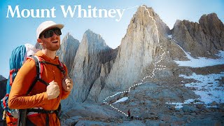
To make it clear, THIS ROUTE REQUIRES A DAY HIKING PERMIT FOR WHITNEY. That is because the day use permit applies to any entry on the trail route. Hiking the mountaineers route as a day hike by itself does not require a permit for day use. Overnight use is the typical Inyo wilderness permit. Route finding for most of the route is easy because the use trail is fully developed. Still, it pays to read a route description. A few decades ago it was much more difficult as there was no meaningful use trail. It is a great route. It has a few short stretches of class 3. The other rock is class 2-3. There is no required class 4 to do this route. There is an option at 14,000 to avoid the steep chute to the summit, which is the trickiest rock section. You traverse westward along the top of the north face. The summit plateau drops as you go west, so the vertical distance steadily lessens as you traverse. The traverse is not difficult - broken rock and moderately sloping to the north, but it steepens quickly so stay as left as possible on traverse. There are other useful pointers about places on the route.
I believe this can be avoided if you head further right before I started climbing - can't guarantee that as that is the route direct but some other commenters have made that feedback.
I want to do mw😊 I probably need to train for like 10,000 years though my hikes are about 12 miles with 2400 feet of climbing and I just started like two months ago
If the section starting at 11:51 is class 3 then I am wondering what a class 4 would be. No one ever seems to claim that a climb is class 4 so I am wondering if class 4 even exists. Maybe climbs go directly from class 3 to class 5 and there is no class 4.
High 3 and low 4 are so experience and opinion based. I’m sure you could make the case that some of those moves are class 4. I think what’s more important is that regardless of your line, there isn’t a straight up option of class 3 unless you really get lucky in picking your line.
From Iceberg Lake, it is a mistake to start up that awful gully as was done in this video. The rocks to the left are far superior and do not present any rock climbing challenge (almost entirely class 2 to 2-3; maybe a very short class 3 move). You only need to be around 100 yards left of the gully. This will not put you any into the steep rock that is the East Face route on Whitney. These rock ramps merge with the gully about half way up. The upper part of the gully is not as awful as the first section.
I would say so - fairly low Class 3. What made it challenging was the amount of loose rock and bits of snow mixed in. Usually, you are hoping for more solid rock so you don't have to fear for your life or those around you when grabbing/stepping on every single piece of rock.


For a free guide on this hike + tips for avoiding the lottery, head here: www.thevirtualsherpa.com/mt-whitney-day-hike-guide/
Easily the best Mt Whitney MR video I’ve seen to date. Thank you times a million for grading the climbs (class 2 vs 3 vs 4) u encountered on the way up. All the other MR videos seem to not include that crucial info. Thx again, and cheers to you
Cheers Randy - no problem, glad you found it helpful.
I drove by this on 395 on my way to Yosemite and said "Damn, I have to see that up close" and after watching this video I plan to do it sooner than later!!
Excellent video.
For reference: The summit plaque (dating to 1930) lists the elevation as 14,496.811 ft. Over the years, the mountain has been measured multiple times in various ways, producing various results; the currently accepted figure is 14,500.8 ft. Mt Elbert (highest point in Colorado) is 14,440 ft - so just 60 ft less than Mt Whitney.
I really enjoyed following along with you on this loop. I know that most people do the Mountaineer’s route-which I’ve never attempted-in two days, camping overnight at (I believe) Boy Scout Lake, then climbing the chute the next day. I’d never imagined someone doing it as a loop (especially not being familiar with the route!), and in one day, no less. You make it look almost “easy” and straightforward; but I know you’ve gotta have solid route finding skills, be competent on Class 3 rock, and be WELL acclimatized to pull this off in such “no sweat” fashion. Bravo, and thanks for the excellent, entertaining-and informative!-documentary.
Thanks Steve, really appreciate the kind words.
Great video log! I haven't read all 118 comments, so this may have already been covered, but... At the 22:22 point of the video, when you notice the cable railing guarding a relatively short section of trail in the middle of the "99 switchbacks" and you call the cables "absurd", your point is well-taken, except for the fact that during certain times of the year, there is water draining over this section, and it can freeze rather quickly. During two of my five ascents - also up the Mountaineers' Route and down the Whitney Trail (sometimes called the "Fisherman's Trail" or "Main Trail") - this section on the switchbacks had iced over as the temperature dropped late in the day, and the cables were absolutely necessary to safely pass without the risk of slipping and possibly falling over the edge. First time I did Whitney, conditions were perfect; and I, too, wondered what the point of the cables were. Picture the same section entirely glazed over with ice and you'll understand. Again: great video! Well done, and Thanks!
That was exciting,surprising and educational. You made it look very easy. My bet is that few people would take the mountaineer route “solo”, so kudos for the badassery.
I did that hike and many others when I was a teenager. Loved to hike but my feet fell apart. Seeing your video brought me so much joy.
So many great hikes and destinations in California.
I really like this channel. I recently had a major medical scare and it woke me up. Hiking has taken the forefront in my life again. Back in the day when I was an avid hiker we didn't have the internet to find hikes and collect data. I enjoy your videos to see if I am able to do these hikes or not. Plus they are just fun to watch. Thanks man. Keep them coming.
My favorite time of the year to do Whitney !
I did this route in late Sept. of 2006 when the Mountaineer's Rt. did not require a permit. I had a permit for the main trail, so I used that to go down. There was more snow then, but this year is in a drought. I had difficulty finding a way out of the Moraine to Iceberg Lake because the ledges were still iced over. At 7:28, I took the rocky slope on the left to the minor notch in front of the shadow. The slope you took was covered in snow. The hard part for me was the scree slope just before the crest at the big notch. I took the first chute, or "final 400" to the summit, which was not difficult, but ironically, I was flummoxed at the very last 8 feet trying to get up a wall. I completed the hike in 16 hrs - 10 up and 6 down.
Nicely done. If you go low from there down to Bubbs creek, your mind will also be blown.
20:36 That is the summit of Mt. Muir behind you (obvious pyramid shaped peak), another California 14er at 14,018 ft.
Awesome, on a bike tour got to hike it & back one day late fall, happy to see the mountaineer trail, very cool vid for that.
Cheers 🍺🍺🍺
Awesome video! Hopefully I’ll make it out there one day. Next week I’ll be in Colorado doing pikes and Elbert with much help from your guides. Thanks!
Oct. 10, 2000 we got hit with a white out blizzard about a half mile from the summit. Grateful to have made it out. Great video thanks.
Next time you’re up there, you ought to tag Mt Muir, an easy short class 3 from the crest trail. It offers an outstanding view of the crest and summit block.
I know, I realized that after - so so stupid not to snag Muir
That was awesome man. I plan on summiting Whitney this year via mountaineers route. Another climb I’m doing this season will be Black Kaweah in Sequoia.
No way I would do this after watching this and other videos. Thanks for the good beta. Congratulations just the same!
Nice video
P.S. The lake at 9:22 is Iceberg lake
Looking down from the foot of Mt. Whitney to the eastern valley results in one of the highest vertical reliefs as well, unlike many of the Colorado 14ers that have a base of over 8000 feet. Well done sir!
Awesome video. I’m heading out in 2 days. Gonna do north fork to iceberg, camp, climb the east buttress (which is 5.7) then come down the mountaineers route. May camp again or head back to the car depending on how dead we feel. Thanks for sharing! I’ve watched a few of your other CO 14er vids for research. Excellent work 🤙
Thanks for documenting this.. my plans are for next summer 2023
Nice to see you're in better general fitness than a few years ago look healthy 👍
Beautiful shots, I’m definitely taking notes from you for the slot canyon trail guides, trying to make them for Arizona! 😊
Was waiting for this one! So sick 🔥
Thanks mick. That looked amazing. After the Colorado 14ers that’s high on my list.
Hi Sherpa! Excellent video! It seems to me you always challenge yourself by taking difficult routes. In this case it is the Mountaineer’s trail in a day. This is the U.S. Army Ranger way of doing things. Rangers lead the way!
I did this exact route in May and had a near death experience in the final chute as three basketball sized rocks whizzed by my head at what seemed to be +100mph, started by something like 9:35. At that time the chute was still snowed in, except for the last ~200ft. The chute is very long, and I couldn't even see the party above me, so a callout wouldn't have mattered. I implore anyone who does this route to be super careful. Also, with snow, you have crampons on, so footing is much more secure in exposed areas like 11:40 (if you know how to walk with crampons on). People have died in that spot, so it's important to have some prior experience if you do go earlier in the season.
If I had to do it again, I'd still go early season (April-May), but would've glissaded down the chute next to the 99 switchbacks on the standard route. The switchbacks were extremely exposed in areas since that face was still covered in snow.
Glad you are okay - I can 100% imagine what a dangerous situation it would be with other people in front of you - especially if they weren’t super experienced. Agree, like I touched on towards the end of the video, this route really should be done with snow for the most safety and fun.
If you are referring to the "final 400" above the notch, to the summit, I had a similar experience. Although it was not close, some hikers above me dislodged a soccer ball sized rock and yelled a warning. I was on a secure ledge and darted to the side, but the rock was far enough away not to be a threat. That chute is not a difficult climb, but definitely worthy of caution.
@@aliensoup2420 mine was actually still in the main chute, about 13,500. I was so spooked that I skipped the final 400 and went the long way around. It was also partially snow covered when I went, and I was by myself.
I believe the 5.7 route is what a friend uses. It branches off to the left of the gulley and ascends the east face. It is not that technical, but has two particularly noteworthy features. First, finding the correct route (unmarked) is difficult. One can waste a LOT of time either backtracking in search of it, or be forced into more technical ascents. Second, a key move is known as the 'Fresh Air Traverse', which entails a brief, but VERY exposed traverse.
Loved this. I think from videos and what I’ve read people prefer this route in winter because of how loose it it in spots. Great video
You were on the John Muir Trail from summit to Trail Crest!
Incredible. Thank you for all the hiking videos you do. They are excellent sources of information that use quite frequently.
I see you hustling bro keep putting in the work and editing you will make it!
I do recommend making a patreon
Make it to what?
Dude I wanted to do this route so badly! Thanks for capturing it on video Sherps!
Great POV footage
JOHN MUIR'S Mountaineers Route!!!
Before it got light enough, I thought you were wearing orange micro shorts. I’m just glad light told the truth. 😂😅. Another great guide! Happy Halloween!
Wow what a hike this was such beauty!! Incredible views. Great video showcasing the beauty of great nature! Thanks for sharing! Be safe on your adventure👍👍👍
Have never been up the mountaineering route it really doesn't look that enticing. Always enjoy day hiking up the smooth and consistent standard route where you can get a pace going and move right along. Always feel good on the way down but seems to be longer down in spite of the ease. Good video.
Without snow, I wouldn't recommend it. With snow, I am sure its a blast. Beautiful terrain all around though.
I camp at upper Boy scout lake and did Whitney's Mountaineer route one day and Mt Russel the next
Nice - that makes sense on what that other social trail up there was 👍🏽
I think you'd like Mt Russell's East ridge
Real fourteeners in California!
Was wondering when you’d take this on, great video!
Thanks Vince, was fortunate to snag this one this year - wasn't in the plans a month ago!
@@TheVirtualsherpa nice! I was reading your trail guide, didn’t realize you could still get spots if you didn’t get one in the lottery. Also, I just happened to notice that it looks like the gpx recording is currently the tour de abyss one instead of the Whitney one.
@@XxxUnderestimatedxxX yeah absolutely not the only way, highly recommend just refreshing the permit page for the dates you want. Can also go starting tomorrow through May 1st as the permits are unlimited
Amazing video. Inspirational
Awesome job as always, keep up the great work!
I’ve done the standard route. I can’t imagine doing this route in the summer. I’ll take my crampons and ice axe up.
Happy halloween
Did the Main Mt Whitney Trail (MMWT) about 13 years ago and as a day hike it's an absolute endurance test (and really sucks on the joints by the end). Would love to get back someday to do the mountaineer route. I'd always heard it was intense and frightening so seeing this footage gave a very realistic idea of what to expect! Living in CO now there are lots of opportunities for practice, too :)
This is on my bucket list! Thanks for doing this video!
You mentioned Boundary Peak. I also did that at the same time as Whitney and man what a difference. Loved Whitney, hated Boundary.
😂 same. Next week’s video and there was a reason I wanted to swap the order
Nice free climb Alex
Great combo route to Whitney in a day. Before long you will be finishing all 14ers in lower 48
Probably a while - getting to the ones in CA is not very easy for me but will def be back to explore more in the Sierras
So fortunate. We were denied the lotto this year. Maybe next year.
Read my tips on the lotto - its NOT the end of your journey if you don't get it. Admittedly, some flexibility is required.
Awesome
This was the most brutal hike my cousins and I did(because of poor planning). Was a year of like 200% snowfall. Hiked in June or July and everyone had legit winter hiking gear like micro spikes, ice axe, etc… and we had sticks we found. Was snow basically the whole way up. Somehow made it up and down the chute. Was wild.
Boots alone are arguably better than micro spikes on steep snow. You can kick steps with boots, micro spikes will give you a false sense of security; if you turn your ankle or start to slip with spikes they can twist right off your boots. Better still would be light crampons, there are aluminum ones out there which are super light weight and good insurance to just throw in your pack if you're unsure of the conditions. Micro spikes are really only advisable on relatively flat terrain where the main hazard is slipping on ice.
Strong work!
Thank you thank you
Enjoyed the video, easy watch and love footage of the sierra in just about any capacity. When you headed up from the notch, it looks like you went way past the standard way. The area you indicated was "higher class 4 or class 5" is the normal way most people go, hardest part is right as you start out of the notch if memory serves. The way you went was probably way sketchier due to the looseness.
Agree yeah - the beta I had steered me a bit off from where I wanted to climb. If you start closer to the notch, I believe there should be much more solid class 3 rock. Regardless though, I stand by my take in the video saying that this would be much more fun and safe with snow.
@@TheVirtualsherpa the portion out of iceberg lake up to the notch is WAY more fun with consolidated snow, for sure.
Crazy. You looked like you had more energy when you finished than when you started! 😂
😂 a 3AM wake up call will do that to ya
Witney was brutally long for me. Have you done mt rainier yet? I have climbed 30 14ers crestone peak as my hardest. I need rainer to het the top 10 highest in the lower 48. Stage 4 cancer and then corona destroyed my legs so im trying to make a comeback to climb a few more. Stay safe up there!
Not yet, but hopefully soon. Glad to hear you are still battling despite the obstacles!
Well done. I enjoy all of your video work. One comment: you included Evans/Bierstaad file in write up and not Mt. Whitney. Thanks for taking us along on your adventures.
It’s been updated thanks 👍🏽
Heck yes
Thanks so much for the video!
This was a great video.
Great video!
Great loop - definitely going to try this one out when we move out west. How much of the trail back could you run?
If you are looking to run it - probably 95+ percent. The trail is in great condition and not very technical.
Super cool terrain, was wondering if you were doing all the state highpoints
Not the goal - but the ones that involve a mountain maybe. Just like exploring new areas 👍🏽
@@TheVirtualsherpa def some differences between whitney and the high points in places like Kansas. Vids on Elbert, Katahdin or even denali are really cool though.
@@djd__998 check out my state high points playlist - got a bunch on there and another one coming next week
When are you hiking mt Whitney again? I’m interested in hiking. I’ll be interested if I can come w you. Thank you. My name is Eric
Nice job - tks
That’s so incredible you were able to do it in a day! Great Job! How long ago did you get a Whitney zone permit?
Snagged it a few weeks before I hiked. Check out the full guide for tips on how to get a permit.
Great, thanks!
I've been to the top..I took 2 days to do it..I can see doing it in a day but I'm inclined to wonder why would you want to..it is an amazing journey ..after taking 2 days ,upon returning I regretted not making an extended trip out of it..there are several trailheads that lead to the pacific crest from the Owen's Valley..my favorite was kearsarge pass near, independence..amazing country!
TUMANGUYO is the real name!!!
Great video. What time did you start in the morning?
I have forgotten how many switchbacks there are on that trail, but I'm certain it's over 90!
Just from trail camp up to trail crest has 99 switchbacks
Awesome terrain! Have you ever considered doing voiceovers for parts with muffled audio/wind?
I do my best to avoid the wind, including a muff on the camera but sometimes it sneaks through.
fwiw, 3300 ft in 3.3 miles would be 1k/mile (1000/5280) which turns out to be ~19%; a stupid incline on a treadmill :D I was thinking about this on Elbert the other day and realized how simple it was to calculate. The typical grade calculation of ft of vert up over 100 ft traveled in the horizontal is good for variable grade and small sections where you need the precision. But just doing averages over larger spans of distance makes it pretty easy to envision the overall grade
To make it clear, THIS ROUTE REQUIRES A DAY HIKING PERMIT FOR WHITNEY. That is because the day use permit applies to any entry on the trail route. Hiking the mountaineers route as a day hike by itself does not require a permit for day use. Overnight use is the typical Inyo wilderness permit.
Route finding for most of the route is easy because the use trail is fully developed. Still, it pays to read a route description. A few decades ago it was much more difficult as there was no meaningful use trail.
It is a great route. It has a few short stretches of class 3. The other rock is class 2-3. There is no required class 4 to do this route. There is an option at 14,000 to avoid the steep chute to the summit, which is the trickiest rock section. You traverse westward along the top of the north face. The summit plateau drops as you go west, so the vertical distance steadily lessens as you traverse. The traverse is not difficult - broken rock and moderately sloping to the north, but it steepens quickly so stay as left as possible on traverse.
There are other useful pointers about places on the route.
that part where you had to do mountain climbing to get to the top.. is that part of the normal route?
I believe this can be avoided if you head further right before I started climbing - can't guarantee that as that is the route direct but some other commenters have made that feedback.
I want to do mw😊 I probably need to train for like 10,000 years though my hikes are about 12 miles with 2400 feet of climbing and I just started like two months ago
maybe just 5000 years of training haha - but in all seriousness, you could 100% do this next year with where you were at now.
If the section starting at 11:51 is class 3 then I am wondering what a class 4 would be. No one ever seems to claim that a climb is class 4 so I am wondering if class 4 even exists. Maybe climbs go directly from class 3 to class 5 and there is no class 4.
High 3 and low 4 are so experience and opinion based. I’m sure you could make the case that some of those moves are class 4. I think what’s more important is that regardless of your line, there isn’t a straight up option of class 3 unless you really get lucky in picking your line.
From Iceberg Lake, it is a mistake to start up that awful gully as was done in this video. The rocks to the left are far superior and do not present any rock climbing challenge (almost entirely class 2 to 2-3; maybe a very short class 3 move). You only need to be around 100 yards left of the gully. This will not put you any into the steep rock that is the East Face route on Whitney. These rock ramps merge with the gully about half way up. The upper part of the gully is not as awful as the first section.
Appreciate this comment, wish I knew this way back when I hiked!
I’m relatively new when it comes to outdoor climbing - is that summit push pretty standard class 3?
I would say so - fairly low Class 3. What made it challenging was the amount of loose rock and bits of snow mixed in. Usually, you are hoping for more solid rock so you don't have to fear for your life or those around you when grabbing/stepping on every single piece of rock.
any tips on how to get the permit? i keep applying and never get it!
Check out the full write up 👍🏽 you absolutely do Not need to get in through the lottery
16 miles, 10 hours, round trip done at 7 times all conditions. No Permitis much Easier in winter
Please it is SIERRA !!! John Muir's The Range of Light!!!