Supervised Classification of Landsat 8 imagery in Google Earth Engine | Part 2

HTML-код
- Опубликовано: 12 сен 2024
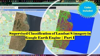
- Part 2 Video "Supervised Classification" of Land Cover Using Landsat 8 Images in Google Earth Engine" presents a detailed guide on how to conduct supervised classification of land cover using Landsat 8 images in Google Earth Engine. The video covers several essential topics, including
selecting Region of Interest (ROI), selecting image, training samples, creating a classifier, and assessing the accuracy of the classification. Additionally, Codes used in the video is offered freely.
------------------------------------------------------------------------------------------
Join this channel to get access to perks:
/ @terraspatial
------------------------------------------------------------------------------------------
Code Link: code.earthengi...
Part 1 Video link: • Supervised Classificat...
Part 2 Video link: • Supervised Classificat...
------------------------------------------------------------------------------------------
#supervisedclassification #landsat8 #googleearthengine


Your channel was a university for me. thank you very much. these tutorials were beneficial for my final year undergraduate research. I started learning GIS & remote sensing from zero level, and now I am pleased with my knowledge.
- Lakshitha hettiarachchi from Sri Lanka 🇱🇰
Thank you very much for a detailed, well explained video! It helps so much to have someone explain it like this, step by step!
Thanks
Thank you for the crisp yet very detailed explanation!
Good work bro.
Thank you so much
You are welcome
Very informative video. Good job
Thanks Mr. David Shaw
Thank you so much for this
Thanks a lot for your valuable comment.
I just had to subscribe
Thank you
Thanks for making the video
So Nice of you
Great work my friend
Thank you
Sir, if i open this exported file in ArcGIS, will i get an attribute table or what?
Good work. there is an error message on line 39 "Line 39: input.sampleRegions is not a function". Please how do you resolve this
Sir I am not able to open this exported image file in ArcGIS.There is a blank image with same high and low value.kindly help in this regard.
Did you solve this? If so, then advice me the way too
Please make Google earth tutorials videos
Yes we are planning to make videos on the topic, thanks for your valuable suggestion.