
- Видео 52
- Просмотров 501 569
Spatial Zone
Добавлен 20 мар 2023
Why Cartographers Get Lost in Null Island
gisgeography.com/null-island/
What if I told you there's an island that isn't on any map, yet countless cartographers unwittingly visit its shores every day? Today, we're going to journey into the realm of "Null Island," where data anomalies converge at a non-existent island.
What if I told you there's an island that isn't on any map, yet countless cartographers unwittingly visit its shores every day? Today, we're going to journey into the realm of "Null Island," where data anomalies converge at a non-existent island.
Просмотров: 841
Видео


Converting Labels to Annotations or Graphics in ArcGIS Pro
Просмотров 6 тыс.Год назад
This video will give you a quick introduction to converting labels in ArcGIS Pro. Should you pick annotations or graphics? We'll compare the two ways to create static labels in your maps.

Mastering Point Clustering in ArcGIS Pro: A Step-by-Step Guide
Просмотров 3,7 тыс.Год назад
When working with datasets that contain a high density of points, it can be challenging to interpret and analyze them effectively. Point clustering helps overcome this challenge by grouping nearby points into clusters. ArcGIS Pro provides a simple way to perform point clustering that's much easier than its predecessor, ArcMap. In this video, I'll show you how to use point clustering in ArcGIS Pro.
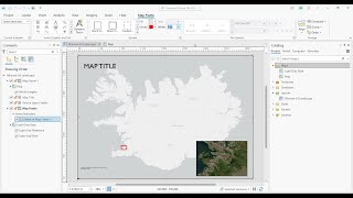
Inset Maps and Extent Indicators in ArcGIS Pro
Просмотров 12 тыс.Год назад
gisgeography.com/map-scale-bar-inset-map-ratio/ An inset map (locator map) is a smaller map that provides a geographic context within a larger main map. In this video, I'm going to show you how to create an inset map and extent indicators in ArcGIS Pro.

Excel Mapping Made Easy: Create 3 Maps in Minutes
Просмотров 1,1 тыс.Год назад
gisgeography.com/excel-maps/ I am going to teach you how to create 3 types of maps in Microsoft Excel. 1) Choropleth Maps - I'll create various types of choropleth maps using countries and zip codes. 2) 3D Maps - You'll learn how to create 3D maps that extrude height with latitude and longitude coordinates. 3) Surface Graphs - We'll also create a surface graph, which is similar to a triangulate...

Supervised Classification in ArcGIS Pro
Просмотров 15 тыс.Год назад
gisgeography.com/supervised-unsupervised-classification-arcgis/ In this video, you'll learn the steps to perform supervised classification in remote sensing. We'll use ArcGIS Pro to collect training samples and classify Landsat imagery using these samples. After collecting training samples, I'll test out the "random trees" and "support vector machine" classifiers. You'll see how both of these s...

15 Editing Tips and Tricks in ArcGIS Pro
Просмотров 8 тыс.Год назад
gisgeography.com/digitizing-editing-tools-arcgis-pro/ In this video, I'll walk you through my 15 favorite editing tools in ArcGIS Pro. From basic operations like editing vertices to more advanced tasks like to aligning features, these tips offer insights to make editing in ArcGIS Pro more effective.
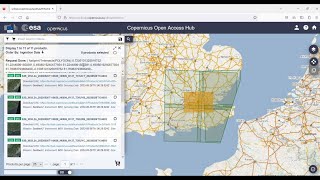
How To Download Sentinel 2 Imagery
Просмотров 5 тыс.Год назад
Copernicus Open Access Hub - browser.dataspace.copernicus.eu/ Sentinel 2 Tutorial - gisgeography.com/how-to-download-sentinel-satellite-data/ In this video, I'm going to teach you how to download Sentinel 2 imagery from the ESA's Copernicus Open Access Hub.

How To Create Heat Maps in ArcGIS Pro
Просмотров 3,5 тыс.Год назад
gisgeography.com/arcgis-heat-map/ A heat map in GIS displays the density of points as hot or cold areas on a map. For example, it's common to see heat maps for crime incidents, population distribution, and disease outbreaks. In this video, I'm going to show you how to create a heat map in ArcGIS Pro without using the kernel density tool. We'll create a heat map directly using the symbology of a...
Natural Earth Data: Mapping the Earth with Public Domain GIS Data
Просмотров 988Год назад
gisgeography.com/natural-earth-data-free-gis-public/ Natural Earth data is a public domain dataset that provides a wide range of geospatial information about the Earth's physical features, including landforms, oceans, lakes, rivers, reefs, glaciated areas, and much more. But it also includes boundaries for countries, states, and provinces, as well as populated places, transportation networks, a...
Pansharpening in ArcGIS Pro
Просмотров 4,1 тыс.Год назад
gisgeography.com/pansharpening/ Pansharpening is an image processing technique that enhances the spatial resolution of an image. By fusing a high-resolution black and white panchromatic image with lower-resolution color imagery, you can achieve a much sharper output image. In this tutorial, I am going to use Landsat imagery and show you how to use pansharpening in ArcGISPro.
Legends Tutorial in ArcGIS Pro
Просмотров 17 тыс.Год назад
gisgeography.com/legends-tutorial-in-arcgis-pro/ In this video, I'll teach you how to create and customize legends in ArcGIS Pro. You'll learn about legend levels, adding items, and various other aspects. I'll also teach you how to convert legends to graphics and ungroup items for ultimate flexibility.
Georeferencing in ArcGIS Pro
Просмотров 4,7 тыс.Год назад
gisgeography.com/georeferencing/ Georeferencing is the process of aligning an image to establish its spatial reference within a specific coordinate system. The goal of georeferencing is to move, scale, rotate and transform any image to an existing map with known geographic locations and coordinates. In this tutorial, I'm going to go through the process of georeferencing a map in ArcGIS Pro.
Composite Bands in ArcGIS Pro (Combining Multiple Images into RGB)
Просмотров 6 тыс.Год назад
gisgeography.com/arcgis-composite-bands/ Composite bands is the process of combining multiple individual bands or images into a single, multiband layer. For example, combining the red, green, and blue bands creates a composite image that resembles natural color, similar to how we perceive the environment with our eyes. I am going to use the "composite bands" tool to combine multiple images into...
How To Convert CSV to Shapefile in ArcGIS Pro
Просмотров 4,5 тыс.Год назад
gisgeography.com/adding-excel-lat-long-coordinates-arcgis/ In this video, I'm going to show you how to convert a CSV table to geographic points so you can use it in your maps. We'll use a CSV with airport latitude and longitude coordinates and convert it to a shapefile with a GCS WGS 1984 coordinate system.
How To Create NDVI Maps in ArcGIS Pro
Просмотров 13 тыс.Год назад
How To Create NDVI Maps in ArcGIS Pro
Creating Sequential and Random Numbers in ArcGIS Pro
Просмотров 4,2 тыс.Год назад
Creating Sequential and Random Numbers in ArcGIS Pro
Unsupervised Image Classification in Remote Sensing
Просмотров 3,5 тыс.Год назад
Unsupervised Image Classification in Remote Sensing
Importing Map Templates with Layout Files in ArcGIS Pro
Просмотров 11 тыс.Год назад
Importing Map Templates with Layout Files in ArcGIS Pro
What Is GIS? A Guide to Geographic Information Systems
Просмотров 98 тыс.Год назад
What Is GIS? A Guide to Geographic Information Systems
Udacity Review - 10 Nanodegree Pros and Cons
Просмотров 182Год назад
Udacity Review - 10 Nanodegree Pros and Cons
QGIS Beginners Guide - Getting Started with QGIS 3
Просмотров 4,2 тыс.Год назад
QGIS Beginners Guide - Getting Started with QGIS 3
How To Download Landsat Imagery From USGS Earth Explorer For Free
Просмотров 22 тыс.Год назад
How To Download Landsat Imagery From USGS Earth Explorer For Free
Very helpful. Thanks
Thank you for this comprehensive information also visit and Unlock the world of geospatial technologies with my RUclips channel! With over 15 years of experience.
Thanks!
Why my classified image is not showing after successful running of SVM as well as Random forest?
I missed the part where you created the legend.
ArcGIS pro sucks. These people seem intent on ruining lives
amazing
This is a great video about GIS. Helpful for getting a foot forward into the field
thanks!
I need to download Landsat 7 dataset but from usgs api. Do you know downloading from api? I use python programming language
How can I get the dataset please
Thx❤
Very practical. Thanks for the video.
Nice
Thank you ❤
thank you
Dude thanks so much. I was using it wrong for hours and would have not realized it if I didn't see this.
Be nice if it was a person talking and not a robot
thank you very much!
gute
What's programming language does GIS use
Mostly Python and R
this was helpful thanks
Thanks for this!
No problemo
Thank you for this.
Thank you .
A question, I have a layer of sidewalks of a municipality, how can I make the size of the labels according to the size of the sidewalk ? because for example, if I set the size to 7 for all of them, in the smaller sidewalks the labels will occupy all the space of the polygon. The fields are called “Area_Ha” that has the information of the size of each sidewalk and the field “Name” that has the name of each sidewalk....Ni CHATGPT has been able to help me.
Thanks a Lot 👌
Thank you. I agree they're much worse in PRO. The wrap options are only applicable to the legend as a whole rather than individual layers included in the legend and wrapping also seems to effect the space between columns in ways that do not make any sense. It was much easier in ArcMap 10.x
GIS helps to know places have high risk zone and propose the different ways of overcome. Thanks.
why labeling is not coming in clustering after points feature visible also?I am asking point feature name
Very very good class and presentation.., Sir you made this very easy and simple to understand. Thank you so much. May GOD reward you greater.
thank you so much
very very useful and clear video
Thanks. Binging a lot of your videos to do maps for my Master's thesis, lol
I know the struggle, lol. Good luck though! I'm currently preparing for my defense 🙃
@@kferr25 I managed to finish my thesis lol. Good luck to you with the defense
needed ts for school thx i got so many pages but at least this'll give me a head start
thank you so much for this very informative video. this is so much helpful
Perfect, thank you 👍
thanks man!
Thank you for this comprehensive information for someone who has literally no idea what GIS is about. You deserve more subscribers for how you present and speak about the data!
Thank you very much!
I am really enjoying your channel. You now have my subscription!
Glad to hear!
If the new merge attribute table become null, even it the same field. Any solution?
That shouldn't happen. Could it be that one field is a "double" and the other is "text"? Sometimes, ArcGIS Pro doesn't like merging different field types
I totally agreed your idea, I am quite hard to adapt how to customize the map components in ArcGIS Pro. Thanks
can you append excel tables to features?
No, you can't. If it's a table feature class, and you're appending Excel records to that... Then, that works
can you clip an image using a graphics polygon instead of a feature?
I haven't done it yet in ArcGIS Pro.... but I think I've seen this functionality in ArcGIS Pro. Worst case scenario is of course to convert from graphic to polygon.
Excellent !!! Thank you very much
Handy thanks
No problem!
It worked better than expected, thanks!
Glad it helped
Hi, some images taken by the corona satellites aren’t showing the download option. Could you help me with downloading them?
Very simple, thank you buddy
No problem 👍