
- Видео 10
- Просмотров 64 526
Peter Chen
Добавлен 22 мар 2020
Towards a Digital Globe: Geographic Information Systems (GIS)
An introduction to Geographic Information Systems (GIS) and the GIS major at the University of Connecticut.
Просмотров: 245
Видео


The Climate Crisis: Why Geography Matters?
Просмотров 1463 года назад
An introduction to Geography (climate change focus) and the Geography major at the University of Connecticut.

Introduction to GIS and UConn GIS Major
Просмотров 4263 года назад
An introduction to Geographic Information Systems (GIS) and the GIS major at the University of Connecticut (UConn).

Downloading Base Map and Free Data in QGIS
Просмотров 24 тыс.3 года назад
Open Street Map feature categories: wiki.openstreetmap.org/wiki/Map_Features
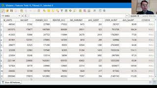
Editing Attribute Table in QGIS
Просмотров 37 тыс.4 года назад
Data source: www.census.gov/cgi-bin/geo/shapefiles/index.php?year=2019&layergroup=States (and equivalent) Coronavirus in the U.S.: www.nytimes.com/interactive/2020/us/coronavirus-us-cases.html#states

Map Styling in QGIS
Просмотров 9954 года назад
Data sources: Interstates (choose Primary Roads “Download national file”): www.census.gov/cgi-bin/geo/shapefiles/index.php?year=2019&layergroup=Roads USstates: www.census.gov/cgi-bin/geo/shapefiles/index.php?year=2019&layergroup=States (and equivalent)

Map Query in QGIS
Просмотров 6584 года назад
Data sources: Interstates (choose Primary Roads “Download national file”): www.census.gov/cgi-bin/geo/shapefiles/index.php?year=2019&layergroup=Roads USstates: www.census.gov/cgi-bin/geo/shapefiles/index.php?year=2019&layergroup=States (and equivalent)

Making First Map in QGIS
Просмотров 3524 года назад
Data source: naciscdn.org/naturalearth/packages/Natural_Earth_quick_start.zip

GIS Applications for Earthquake Shelter Planning
Просмотров 6644 года назад
GIS Applications for Earthquake Shelter Planning
QGIS Lab Set Up
Просмотров 2644 года назад
Data source: naciscdn.org/naturalearth/packages/Natural_Earth_quick_start.zip
Can you demonstrate how we can prepare a shelter plan in GIS ? Or could you please provide me with the link of your research relating to this topic, sir.
lovely, have been looking for this, Thanks Alot, Bravo
Why is my attributes table different it is not like yours that look like a real table like from excel mine displays its feature one click at a time. How can I fix it?
When I zoom in my resolution doesn't improve, remains impossibly blurry - any fixes?
Thank you! I'm a new QGIS user and this was a great beginner tutorial.
Thanks for sharing your experience.
what to do if osm only appeared? i need map that show roads. help im currently new to this and im student
I had the same problem, it's explained how to solve that here: ruclips.net/video/62i5n0NsH48/видео.html
Best guide I have found that makes the program usable quickly to the laymen. Thanks for sharing
Good day peter ,please i need help ,i want to do spatial analysis us QGiS, i have my data
Extremely useful and clear, thanks!
Thank you Peter. Very clear and informative video much better than of others. I have subscribed for your channel and would be looking forward to watching your next videos
thanks it was helpful. but i still have some confusions regarding Field calculator. What if i want to give a certein name to only selected lines. For example i want to give attributes of "Old data" to the all the features that were created yesterday.
Hi. Can I ask a question? Why does my Qgis don't have an Open Attribute Table when I right click the layer map?
I think it is because there are no editable attributes in the chosen dataset. Try checking other datasets. This happens to me as well.
Can we download region area of a country in this way?
Hi Peter, does OSM attribute table filles null values automatically? I have extracted highways for a state in India. In the extracted shapefile, the attribute table has most of the values as null.
Thank you. It is very helpful.
I am just wondering how to put all examples to the same number, I try rn in my project fro example to generalise the field of objects and need them all on the same number, and I dont want to do so manual bc there are severel thousand of those...
Please make us more videos about joining attributes tables,symbology,and using expressions to select data in the attribute table. You know how to explain, thanks
Thanks this was helpful for me
Ey could i just edite all 6.000 dates (year of fund) with same year?
Very helpful :)
for some reason I am not able to change the NULL values for the real values I have. What could be the problem?
You may have specified the wrong data type or set the length to zero when creating the new column. For example when "type" is set to "integer", you can only enter numbers, not letters. If "length" is set to "0", you can't enter anything. Apart from that, make sure you are still in toggle editing mode. If it's neither of those, I don't know either.
Just antastic
I am unable to copy line layer data to another line data layer will u plz help me out I tried copy paste by going in edits option
I'm using 3.16 lastest version QGIS. I have a small issue while using attribute table. While Creating New Field, Provider Type Value is not displaying for me. How to enable it...?