
- Видео 60
- Просмотров 78 147
GIS Tutorial
Непал
Добавлен 15 фев 2022
Find out easy solution and tutorial of ArcGIS @GIS Tutorial #gistutorial
ArcGIS installation
Lecture of GIS
Spatial analysis
Land use and land cover
DEM work
Research study work
Climatic data work
ArcGIS installation
Lecture of GIS
Spatial analysis
Land use and land cover
DEM work
Research study work
Climatic data work
How to add bargraph in ArcGIS
This tutorial is about how you can add bar graph or pie chart in your study site different concentration of sample.
Просмотров: 185
Видео


Creating study area map in ArcGIS
Просмотров 116Месяц назад
This tutorial is about the preparation of study area map with proper grid layout with your country shape file.

How to download global active fire and wildfire data
Просмотров 2302 месяца назад
Fire Information for Resource Management System (FIRMS) The Fire Information for Resource Management System (FIRMS) provides access, with minimal delay, to satellite imagery, active fire/hotspots, and related products to identify the location, extent, and intensity of wildfire activity. FIRMS tools and applications provide geospatial data, products, and services to support the broader fire mana...

How to download DEM data, Slope data, Roughness and Aspect Map- Part 1
Просмотров 3543 месяца назад
Namaste everyone. This tutorial is all about the process how can you download the DEM data with other rekated data for your respective research interest. Thank you for watching #gistutorial #nepal

How to create gibbs diagram Part 2
Просмотров 1813 месяца назад
This is about how can you prepare the Gibbs diagram for water quality analysis. #gistutorial #gibbsdiagram #waterqualityanalysis
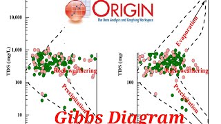
How to create Gibbs diagram in Origin Part 1
Просмотров 4463 месяца назад
This tutorial is about how to prepare gibbs diagram in Origin Software. Gibbs duagram is one of the hydrogeochemical characterisqtion process of water quality parameters.

How to merge graph in origin #tutorial
Просмотров 1294 месяца назад
learn merging graph in origin. #origin #gistutorial #tutorial #nepal

How to extract elevation data from DEM file #gistutorial
Просмотров 4384 месяца назад
Welcome back to GISTutorial, Todays tutorial is about the extraction of elevation data using the DEM file for the specific locations with having longitude and latitude data of those area. Happy New Year 2081! Best wishes

How to baseline correction and smoothing of FTIR data in Origin #statistics #origin #gistutorial
Просмотров 2,6 тыс.5 месяцев назад
This tutorial is about smoothing of FTIR data @gistutorial_easytutorial
Download global water data #gistutorial #hydrolakes #hydrowaste
Просмотров 3525 месяцев назад
Welcome back to the this very useful GIS tutorial video. This tutorial is about how to download water bodies like lakes and reservoirs. This datasets are free, provided by HydroSHEDS. HydroSHEDS www.hydrosheds.org/products HydroWaste www.hydrosheds.org/products/hydrowaste Hydro Lakes / Waterbodies Download Page: www.hydrosheds.org/products/hydrolakes #gistutorial #gistutorialinNepal #womeningis...
How to use multiple maps in single layout
Просмотров 5116 месяцев назад
This tutorial focus on how to manage the different maps in single layout in ArcGIS which gives more visualization and presentation.
Spatial variation map in ArcGIS #gistutorial
Просмотров 4549 месяцев назад
Spatial variation map in ArcGIS #gistutorial
How to add basemap in ArcGIS @gistutorial
Просмотров 1,7 тыс.11 месяцев назад
Add a new basemap layer to your map. Right-click the data frame name in the table of contents and click New Basemap Layer. This adds a new basemap layer in your table of contents. The basemap layer behaves much like a group layer in that you can drag content into it. #basemap #gistutorial #GIS #esri Please Like/Share/Subscribe GIS Tutorial
How to add reference in research paper manually #addreference #research
Просмотров 99Год назад
This tutorial is about how to add references in research paper, thesis step by step guidance without using any software. A references page is the last page of an essay or research paper that's been written in APA style. It lists all the sources you've used in your project so readers can easily find what you've cited. #researchpaper #citations #howtoaddreference #howtocite
How to download global water surface data for free #gistutorial #surfacewaterdata
Просмотров 460Год назад
How to download global water surface data for free #gistutorial #surfacewaterdata
How to use data bars in Excel #databars #gistutorial
Просмотров 156Год назад
How to use data bars in Excel #databars #gistutorial
Urban Heat Island (UHI) assessment using satellite imagery with GIS #gistutorial #Urbanheatisland
Просмотров 2,5 тыс.Год назад
Urban Heat Island (UHI) assessment using satellite imagery with GIS #gistutorial #Urbanheatisland
How to remove No data value from satellite image
Просмотров 256Год назад
How to remove No data value from satellite image
How to create bathymetric map in ArcGIS #gistutorial #bathymetricmap #lakevolume
Просмотров 6 тыс.Год назад
How to create bathymetric map in ArcGIS #gistutorial #bathymetricmap #lakevolume
LULC MAP with ESRI 10 m resolution shape file @gistutorial_easytutorial
Просмотров 784Год назад
LULC MAP with ESRI 10 m resolution shape file @gistutorial_easytutorial
LULC accuracy assessment @gistutorial_easytutorial
Просмотров 873Год назад
LULC accuracy assessment @gistutorial_easytutorial
How to change projection coordinate system of Raster in ArcGIS @gistutorial_easytutorial
Просмотров 171Год назад
How to change projection coordinate system of Raster in ArcGIS @gistutorial_easytutorial
Pivot Table in MS Excel @gistutorial_easytutorial
Просмотров 63Год назад
Pivot Table in MS Excel @gistutorial_easytutorial
How to merge multiple graphs using Origin Software #graph #merge_graph #gistutorial
Просмотров 182Год назад
How to merge multiple graphs using Origin Software #graph #merge_graph #gistutorial
Drinking water quality parameter map with spatial analysis /IDW/Drinking Weightage map
Просмотров 2,7 тыс.Год назад
Drinking water quality parameter map with spatial analysis /IDW/Drinking Weightage map
Digitization in Google Earth and working with KML and KMZ format / Import as Shape File in ArcGIS
Просмотров 546Год назад
Digitization in Google Earth and working with KML and KMZ format / Import as Shape File in ArcGIS
How to import shape file in Google Earth @gistutorial_easytutorial
Просмотров 583Год назад
How to import shape file in Google Earth @gistutorial_easytutorial
Download free world geology shape file/Geology Data, Shapefile for any Location
Просмотров 9952 года назад
Download free world geology shape file/Geology Data, Shapefile for any Location
What's on channel ?? Welcome to GIS Tutorial
Просмотров 972 года назад
What's on channel ?? Welcome to GIS Tutorial
How to calculate Topographic wetness index using ArcGIS
Просмотров 5612 года назад
How to calculate Topographic wetness index using ArcGIS
Would you mind to share me your file please. I would be grateful to you please 🙏
Would you mind to share me your file please. I would be grateful to you please 🙏
I have done these steps for aspect , but when calculating the area aspect , I cannot because it's write (area disable) ? What the reason?
Change coordinate system .It should be in PCS(,Projected Cordinate system).So change from GCS (geographic Cordinate system) to PCS.Layers (left hand side ,top) ke properties me jaa kar kar sakte ho.
very useful tutorial many thanks.
Do u know in global mapper n qgis
Thank you a lot Manisha di 🙏
Thank you didi. We learned alot from your video.
Very nice. Easy to understand. Thank you 😊
This video literally saved my undergrad fellowship project. Thank you so very much for sharing this!! I love the background music too - definitely soothing after an afternoon of freaking out about how to get this done
💯👌
Make a video on prediction of future LST map please
cannot open the website now
global-surface-water.appspot.com/
Keep uploading❤
I will try my best
If you want mean slope degree, you jsut go to layer properties, then click source, statistics and there is a min, max and mean numbers for slopes in your area.
Thank you very much for your help! I would like to know how to reverse the graph like yours. 🙏
I not getting which reverse? Scale changing or ?
@@gistutorial_easytutorial how to reverse the curve? Thanks again
@@tanopatricefato2442 She reversed the "From" and "To" in the X axis scale
Hey,where can I get this software from?
I can't able to download arc swat in my laptop
Sometimes due to the other software also you can download it or check if you have 64 bit or 34 bit file
I have successfully installed both ArcGIS and acrswat but the arcswat not appearing into the ArcGIS.. why????
In the beginning, you had made slope from DEM by DEGREES and after reclassifying and converting to polygon you just rewrote it to percent. Shouldn't that be ° (Degrees) actually and not percents?
🎉
🎉
🎉
Nice
🎉
🎉
❤
❤😊
❤
❤❤❤❤❤❤❤
❤❤❤❤❤
❤
❤❤❤❤❤❤❤
❤❤❤❤❤❤❤❤❤❤
❤❤❤❤❤
❤❤❤❤❤❤❤❤
❤❤❤❤❤❤
🎉🎉🎉🎉🎉🎉
❤
❤❤❤❤❤
Thank-you for the video
I like your vedeo but how do I input the Qcal value for the band 6 clip its giving me hard time to iput it into the raster calculator
you can use landsat image for that
Hello.....make some more videos on these
ruclips.net/video/pRhpd4PLGuw/видео.htmlsi=wj3X-U4sS16Fd96n Go through this video
ruclips.net/video/pRhpd4PLGuw/видео.htmlsi=wj3X-U4sS16Fd96n
Hello sir
👍👍👍👍
Hey! I'm working on something similar... Need your help
Wow what a great tutorial. Thank you for the guidance.
I have only four years water quality data of one location . Can i make spatial distribution map?
Ofcourse you can but u should have wide range of sampling location with maximum sample number
can you send me the depth data of Begnas Lake?
Units of density is not shown ??
Nice video😊
🙏🙏🙏🙏
🎉🎉