
- Видео 10
- Просмотров 180 591
MB Geospatial
США
Добавлен 16 авг 2020
This channel is all about basic information and detailed demonstrated lectures on following Geospatial engineering & day to day use applications.
•\tArcGIS
•\tQGIS
•\tENVI
•\tERDAS IMAGINE
•\tGoogle Earth
•\tPCI Geomatica
•\tMS Office
•\tMicrosoft Excel
•\tAutoCAD etc.
and much more basic software.
There may be many more videos related to the latest technology, the latest inventions, news, awareness, education etc.
•\tArcGIS
•\tQGIS
•\tENVI
•\tERDAS IMAGINE
•\tGoogle Earth
•\tPCI Geomatica
•\tMS Office
•\tMicrosoft Excel
•\tAutoCAD etc.
and much more basic software.
There may be many more videos related to the latest technology, the latest inventions, news, awareness, education etc.
Hydrological modeling
This channel is all about basic information and detailed demonstrated lectures on following Geospatial engineering & day to day use applications.
• ArcGIS
• QGIS
• ENVI
• ERDAS IMAGINE
• Google Earth
• PCI Geomatica
• MS Office
• Microsoft Excel
• AutoCAD etc.
and much more basic software.
There may be many more videos related to the latest technology, the latest inventions, news, awareness, education etc.
#Learning #ArcGIS #QGIS #AutoCAD
• ArcGIS
• QGIS
• ENVI
• ERDAS IMAGINE
• Google Earth
• PCI Geomatica
• MS Office
• Microsoft Excel
• AutoCAD etc.
and much more basic software.
There may be many more videos related to the latest technology, the latest inventions, news, awareness, education etc.
#Learning #ArcGIS #QGIS #AutoCAD
Просмотров: 221
Видео


how to install Filmora X complete process
Просмотров 65Год назад
This channel is all about basic information and detailed demonstrated lectures on following Geospatial engineering & day to day use applications. • ArcGIS • QGIS • ENVI • ERDAS IMAGINE • Google Earth • PCI Geomatica • MS Office • Microsoft Excel • AutoCAD etc. and much more basic software. There may be many more videos related to the latest technology, the latest inventions, news, awareness, ed...

How to Create Account in Earth Explorer (USGS) And Download Free Satellite Data
Просмотров 1,2 тыс.3 года назад
This channel is all about basic information and detailed demonstrated lectures on following Geospatial engineering & day to day use applications. • ArcGIS • QGIS • ENVI • ERDAS IMAGINE • Google Earth • PCI Geomatica • MS Office • Microsoft Excel • AutoCAD etc. and much more basic software. There may be many more videos related to the latest technology, the latest inventions, news, awareness, ed...
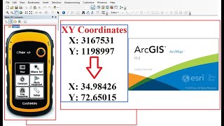
How to add XY Coordinates of GPS in ArcGIS/ArcMap
Просмотров 7 тыс.3 года назад
This channel is all about basic information and detailed demonstrated lectures on following Geospatial engineering & day to day use applications. • ArcGIS • QGIS • ENVI • ERDAS IMAGINE • Google Earth • PCI Geomatica • MS Office • Microsoft Excel • AutoCAD etc. and much more basic software. There may be many more videos related to the latest technology, the latest inventions, news, awareness, ed...

3D Analysis in ArcGIS / ArcScene
Просмотров 20 тыс.3 года назад
This channel is all about basic information and detailed demonstrated lectures on following Geospatial engineering & day to day use applications. • ArcGIS • QGIS • ENVI • ERDAS IMAGINE • Google Earth • PCI Geomatica • MS Office • Microsoft Excel • AutoCAD etc. and much more basic software. There may be many more videos related to the latest technology, the latest inventions, news, awareness, ed...

Visualization of 2D Data into 3D view Using ArcScene
Просмотров 2,1 тыс.3 года назад
This channel is all about basic information and detailed demonstrated lectures on following Geospatial engineering & day to day use applications. • ArcGIS • QGIS • ENVI • ERDAS IMAGINE • Google Earth • PCI Geomatica • MS Office • Microsoft Excel • AutoCAD etc. and much more basic software. There may be many more videos related to the latest technology, the latest inventions, news, awareness, ed...

How to calculate Area / Geometry in ArcGIS from Attribute Table
Просмотров 5 тыс.3 года назад
This channel is all about basic information and detailed demonstrated lectures on following Geospatial engineering & day to day use applications. • ArcGIS • QGIS • ENVI • ERDAS IMAGINE • Google Earth • PCI Geomatica • MS Office • Microsoft Excel • AutoCAD etc. and much more basic software. There may be many more videos related to the latest technology, the latest inventions, news, awareness, ed...

Hydrological modeling in ArcGIS / ArcMap
Просмотров 142 тыс.4 года назад
For more Videos Please Share, Like, Subscribe and press on the bell icon Email: mbgeospatial@gmail.com This channel is all about basic information and detailed demonstrated lectures on following Geospatial engineering & day to day use applications. • ArcGIS • QGIS • ENVI • ERDAS IMAGINE • Google Earth • PCI Geomatica • MS Office • Microsoft Excel • AutoCAD etc. and much more basic software. The...

How to Mosaic and Extract by Mask Raster DEM with 12.5 Spatial Resolution Using ArcGIS
Просмотров 1,1 тыс.4 года назад
This channel is all about basic information and detailed demonstrated lectures on following Geospatial engineering & day to day use applications. • ArcGIS • QGIS • ENVI • ERDAS IMAGINE • Google Earth • PCI Geomatica • MS Office • Microsoft Excel • AutoCAD etc. and much more basic software. There may be many more videos related to the latest technology, the latest inventions, news, awareness, ed...
How to Download administrative boundaries of any Country (GIS Shapefile) | MB Geospatial
Просмотров 1,4 тыс.4 года назад
How to Download administrative boundaries of any Country (GIS Shapefile) | MB Geospatial This channel is all about basic information and detailed demonstrated lectures on following Geospatial engineering & day to day use applications. • ArcGIS • QGIS • ENVI • ERDAS IMAGINE • Google Earth • PCI Geomatica • MS Office • Microsoft Excel • AutoCAD etc. and much more basic software. There may be many...
What screen recorder you use
Thank you so much for the video. Hi everyone! I am new to this. I need TIN data from DEM data for my physical-based model as an input. At which stage should I convert my basin to TIN, or should it be the first step before starting this? If someone can direct me, I would be so happy.
why is this video without sound 😢
thank you, an excellent video. Almost all the models are covered kdb💯
Thanks. Great work. I have a question. Can I draw the Drainage manually ?
Hello sir, is there a reason why in minute 5:26, in the break values, you added the value 1200? Because I see that later on the video you use that same number
there is no voice right?
I just wish there was audio because I don't Understand anything. I followed the video but didn't understand anything😥
sir, what is the conclusion of this analysis????
ممكن اسم البرنامج البيسجل وبيحدد الرسومات انا بنزله بس مختلف تماما عنه لو في لينك
bro how to show arrow direction..which you show just before?
no sound...no valume?
Hello, please do you have a video that shows how to create the DEM for a country?
Looking forward to learn more from you
I need your expertise guidance.. 🙏🏻🙏🏻 Suppose I have ~200 sub watershed, and I want to calculate morphometric parameters of them. How to process them ? (Without doing individually)
Hello , I also need help on this. Could you assist me?
@@RamPoudel-pj3ki I’ll try. Tell me
@@thecopy9975 I also need to calculate morphometric parameters for many watersheds but while calculating stream number and other parameters it doesn't seem to be displaying the correct answer
@@thecopy9975 How did you create the sub-watersheds from watershed. did you did manually by placing the pour points
Sorry, I don't watch videos without sound
There is no sound!
x field and y field drop down is empty no lattitude and longitude there
good job, it's very helpful
❤💪
good video thanks
can u share link download arcmap 10.8 sir? cause my software (10.8) can't use tool hydrologi Thank's
HOW to generate a map of dem bathymetric with ARC-GIS
Welcome to the new Google Earth earthtopomaps.com/ Thanks for watching!
thank you... an excellent video. almost all the models are covered.
Thank you so much for the video. Can you share your data set so that I can try MB Geospatial
Sir, can you suggest some project topics related to hydrology
Very interesting video with good explanation, Than you sir!
It's great. it only lack the audio
Great tutorial, I've been digitizing stream based off a hillshade. Finally my index finger can relax lol.
bravo
Hello. Can you send me your data for the work process, because I wanted to do it too.
?
Great Tutorial. All the best man.
How can i download a dataset for my area of interest
download your area of interest from USGS website
Kindly do my request.Make a video again on how you get the polygon (shapefile) and DEM(shapefile).and how to create from CONTOUR to TIN then main catchment river to fill,flow dir.flow accu.,stream order,stream order to features.meaning from start to complete map.step by step.kindly do that for me friends.Thank you and God bless you more.
Hi! I am new in this field. I need TIN data from DEM data for my physical-based model as an input. At which stage should I convert my basin to TIN, or should it be the first step before starting this? If someone can direct me, I would be so happy.
It would be helpful if you plz share the data
Sir can u share the data
U can get it from usgs
great video but no sound.
Hello my question is about for fill, why did you use 30 for raster analysis?
#perfect kept it up
awesomeeeeeeeeeeeeeee
how do you put break value in flow acc ?
Great video, Could you share the data sample, Will be much appreciated
U can get it from usgs
Please make video on merging of 5-6 dems and watershed delineation
thank u so much
Thank you very much , Great video.
thanks
Great, can you share sample data?
U can get data from usgs site
Hello Please what Software are you drawing the arrows with?
thank you Man for this awesome video. could you plz send me the dataset contact.daivano@gmail.com