
- Видео 19
- Просмотров 88 823
Fool's Workshop
Добавлен 8 окт 2018
Tutorial videos by Konrad M. Lawson (@kmlawson), mostly for teaching modules at the University of St Andrews, School of History in the Institute for Transnational & Spatial History (spatialhistory.net).
14 - QGIS Tutorial - Fixing Messy Boundaries Using Difference
Using QGIS 3.14, this shows a workflow for fixing mismatched boundaries when drawing from multiple vector boundary datasets of differing accuracy or resolution.
Uses dissolved prefecture boundaries from 1911 v6 China HGIS data:
chgis.fas.harvard.edu/
Uses country data from Natural Earth Data:
www.naturalearthdata.com/
Uses dissolved prefecture boundaries from 1911 v6 China HGIS data:
chgis.fas.harvard.edu/
Uses country data from Natural Earth Data:
www.naturalearthdata.com/
Просмотров: 3 675
Видео


12b - QGIS Tutorial - Using an Inner Join to Add Location Geometries from Another Table
Просмотров 8904 года назад
by Konrad M. Lawson (@kmlawson) for the Institute for Transnational & Spatial History (spatialhistory.net), University of St Andrews. My thanks to user FSimardGIS on gis.stackexchange.com for explaining the use of inner join on QGIS. gis.stackexchange.com/questions/376860/depicting-table-of-imported-csv-points-with-lat-long-in-another-table-in-qgis

13 - QGIS 3.10 Tutorial - Flows and Network Visualization II - Simplifying Things
Просмотров 4 тыс.4 года назад
by Konrad M. Lawson (@kmlawson) for the Institute for Transnational & Spatial History (spatialhistory.net). This is a follow-up video to this tutorial on network/flow depiction in QGIS: ruclips.net/video/gXp0FJAkql0/видео.html Also demonstrates a curved label technique shown by Klas Karlsson in this video: ruclips.net/video/Qof4oDLxcmE/видео.html The globe-like orthographic projection I’m using...

Organising your Historical Data in Excel - Filtering and Custum Views
Просмотров 1,6 тыс.4 года назад
by Konrad M. Lawson (@kmlawson) for the Institute for Transnational & Spatial History (spatialhistory.net), University of St Andrews. How to filter and create a shortcut filter for a merged data sheet.
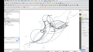
12 - QGIS 3.10 Tutorial - Flows and Network Visualization
Просмотров 14 тыс.4 года назад
by Konrad M. Lawson (@kmlawson) for the Institute for Transnational & Spatial History (spatialhistory.net), University of St Andrews. In this tutorial, I work through Anita Graser’s written tutorial on flows in QGIS, but with an example (less than ideal) of a social network. anitagraser.com/2019/05/04/flow-maps-in-qgis-no-plugins-needed/

Adding ID Columns to Node and Edge Tables Using Excel Lookup()
Просмотров 4,3 тыс.4 года назад
by Konrad M. Lawson (@kmlawson) for the Institute for Transnational & Spatial History (spatialhistory.net), University of St Andrews. This tutorial shows you how to take a node and edge table you are planning to import into network analysis software and add a column with unique ID numbers.

Using VLookup and Merging Material from Historical Sources
Просмотров 924 года назад
by Konrad M. Lawson (@kmlawson) for the Institute for Transnational & Spatial History (spatialhistory.net), University of St Andrews. If you have collected material from historical sources and want to merge some columns of this material dynamically into a new sheet you can use Excel's VLookup method.

Simple Network Visualization for Historians using Cytoscape
Просмотров 1,4 тыс.4 года назад
by Konrad M. Lawson (@kmlawson) for the Institute for Transnational & Spatial History (spatialhistory.net), University of St Andrews. A quick survey of a typical workflow to bring a network into Cytoscape and do some basic styling.

11 - QGIS 3.2 Tutorial - Georectification and Vector Tiles Reader Basemap
Просмотров 2 тыс.6 лет назад
by Konrad M. Lawson (@kmlawson) for the Institute for Transnational & Spatial History (spatialhistory.net), University of St Andrews. In this tutorial we grab some vector tile data from OpenStreet Map, and georectify a historical map with a slightly different method: referring to points on the map canvas from our base map. Some layers and links used here: Klas Karlsson's basemap script: github....
10 - QGIS 3.2 Tutorial - Clipping and Styling Elevation Layers - Adding Contour Lines
Просмотров 4 тыс.6 лет назад
by Konrad M. Lawson (@kmlawson) for the Institute for Transnational & Spatial History (spatialhistory.net), University of St Andrews. QGIS 3.2 Tutorial - Importing a DEM Elevation Raster Layer Clip Raster by Mask Layer; Adding Hillshade Creating Contours and Contour Line Labels Layers used: www.naturalearthdata.com/ Downloads - Large scale - Cultural - Admin 0 - Countries (4.7MB) E30N20 raster ...
9 - QGIS 3.2 Tutorial - Tracing, Smooth Geometry, SVG Fill, Clip, and Difference
Просмотров 7 тыс.6 лет назад
by Konrad M. Lawson (@kmlawson) for the Institute for Transnational & Spatial History (spatialhistory.net), University of St Andrews. This tutorial shows you how to create shapes that automatically snaps to a coastline layer, for example, uses a geometry generator to show a smoother version of a polygon, fill a layer with an SVG, and shows how to use Clip, Difference, and Symmetrical Difference...
8 - QGIS 3.2 Tutorial - Count Points in Polygon
Просмотров 3,1 тыс.6 лет назад
by Konrad M. Lawson (@kmlawson) for the Institute for Transnational & Spatial History (spatialhistory.net), University of St Andrews. Tutorial showing how to count points overlapping polygons in a separate layer and then styling on the output. Layers used: National Records of Scotland - Settlements 2016 Centroids www.nrscotland.gov.uk/files//geography/dataset/settlements2016centroids.zip Local ...
7 - QGIS 3.2 Tutorial - Distance to Hub
Просмотров 2,7 тыс.6 лет назад
by Konrad M. Lawson (@kmlawson) for the Institute for Transnational & Spatial History (spatialhistory.net), University of St Andrews. This tutorial takes the task in our last video and accomplishes it by another method: by using a layer of railway stations as "hubs" and settlements as "spokes" we can create a layer that adds a "distance to hub" and name of hub to the data for each spoke. We can...
6 - QGIS 3.2 Tutorial - Buffer and Intersect
Просмотров 7 тыс.6 лет назад
by Konrad M. Lawson (@kmlawson) for the Institute for Transnational & Spatial History (spatialhistory.net), University of St Andrews. In this tutorial I demonstrate a simple buffer and then an intersect between a point layer and a buffer. The hypothetical example task is locating all communities within 3km of a train station. The layers used here are from: www.naturalearthdata.com/ Downloads - ...
5 - QGIS 3.2 Tutorial - Table Join
Просмотров 6726 лет назад
by Konrad M. Lawson (@kmlawson) for the Institute for Transnational & Spatial History (spatialhistory.net), University of St Andrews. In this tutorial, I demonstrate a simple table join. Data doesn't always come in the exact form you need it in, and that is true here too: in this particular case there is a bit of cleaning up of the data before importing it into QGIS 3. The layers used here are:...
4 - QGIS 3.2 Tutorial - Depicting a Smooth Route or Path
Просмотров 9 тыс.6 лет назад
4 - QGIS 3.2 Tutorial - Depicting a Smooth Route or Path
3 - QGIS 3.2 Tutorial - Labels, Filter, Graduated Symbols by Color and Size
Просмотров 17 тыс.6 лет назад
3 - QGIS 3.2 Tutorial - Labels, Filter, Graduated Symbols by Color and Size
2 - QGIS 3.2 Tutorial - Editing a Vector File and Adding Object in a New Shapefile
Просмотров 1,4 тыс.6 лет назад
2 - QGIS 3.2 Tutorial - Editing a Vector File and Adding Object in a New Shapefile
1 - QGIS 3.2 Tutorial - Adding Coastline Vector Layer and Georeferencing Historical Map
Просмотров 4,4 тыс.6 лет назад
1 - QGIS 3.2 Tutorial - Adding Coastline Vector Layer and Georeferencing Historical Map
Very VERY helpful, thanks!
when im adding virtual layer im getting this error after pressing test "Query preparation error on PRAGMA table_info(_tview): no such column: a.ID" can you help me please
Thank you for this tutorial :)
Hi, Thanks For this excellent video, could you please share the excel document you are working with. I have trouble in following each step!
Well explained, thank you
so helpful. thank you
Thank you, It is helping. I think with this I will solve my problem. In one case it solved, I will try with other cases. Thank you. I am gratefull with you.
Thanks! It helps me a lot!
can i plot multiple routes with this method?
Thank you very much. It was a gold mine.
thanks, good explanation and great video
Great!
Thank you! This is so helpful!
Thanks a lot!!
Thanks a lot!
Thanks. Nice video. I created a buffer for each centroid and would like to compare it to stations (points on another level). Especially, I would like to know which buffer have accessible stations within 3 kilometres. intersection
Congratulations and thanks a lot for the great explanation
I have my tables set up in the same way to track networking among correspondents - but when I add the virtual layer no lines are showing up connecting the idfrom and idto.... I've been trying to troubleshoot this for a couple days now and am at a loss of what I have set up wrong.
I am preparing distribution maps of some bird species and I have various issues regarding tracing, and geometry. Very useful for me. Thanks!
i guess I am pretty off topic but does anybody know a good site to watch newly released series online ?
Can you please tell how to create network using node and edges
This series on the flow maps has been amazing! Thank you
i know it is kind of randomly asking but does anyone know of a good site to watch new series online ?
@Nolan Drake Lately I have been using FlixZone. Just search on google for it :)
How come the historical map and the open map have the same projection?
Nice Tuto! Congrats! When I want to test the Virtual layer, I always have messages of syntax error, I triple check and I am sure all the text are equal. I am using QGIS 3.4. Do you think It can come from QGIS version?
A tip: you can watch series at flixzone. Me and my gf have been using them for watching a lot of movies during the lockdown.
@Kameron Desmond definitely, I've been using Flixzone} for months myself :D
Hi, when I try to change the arrow line width I don't have any option in the source bottom. You know what could be the problem?
the same here, but when i typed the option name appeared
Wonderful demonstration
Than you so much for your video!
A tip: you can watch series at flixzone. I've been using them for watching loads of movies recently.
@Alec Gerardo Definitely, been watching on Flixzone} for since december myself :D
Thank you so much! I have a question: suppose one also has a certain number of people staying within the city, and you'd like to visualize that. Is there a way to create arrow loops from one city to itself in QGIS as well?
I haven't thought about that before. Of course, if you have exacts addresses of people, and you zoom in to the level of the city, those arrows could point from one person's address to another's just as set up in this video. However, if zoomed out, I am not sure it would be very clear without a lot of customisation for those specific arrows since the arrow heads would overlap and need fixing, but also the bend would need to be different for those local cases. I'm sure it could be done, but not sure how well it would as a visualisation.
@@konradlawson2912 Hmmm alright, thank you for your thoughts. I'm now trying to do it by creating a set of copy set of points just next to the original ones. Then I proceed to create arrows between the original ones to the copies. In order to create the loops, it is indeed important to adjust the bend. I'm not entirely sure yet how to customize the bend in such a way that it is proportional to the distance between the points though. Or perhaps it's easier to manually adjust the bend for each pair, if one has a limited amount of nodes? If so, do you perhaps know how to manually adjust the bend of each arrow?
Very good!
Thank You!
4:55 that Bob Ross moment
:p Hehehe, maybe they wanted to be orange? We'll never know.
I have kept working on some of these base maps (e.g. merging South Asian countries for colonial India, merging central asian countries into Russia for Soviet Union, etc.). Eventually I'll share these sources for anyone who might want to use them in teaching.
A tip: you can watch movies on flixzone. Been using them for watching a lot of movies during the lockdown.
@Alijah Kohen yea, I've been watching on flixzone for since december myself :)
you should upload more often.
This was indeed helpful! Thankyou! :) Btw, Your voice is so amazing! <3
You prolly dont give a shit but if you are bored like me during the covid times then you can watch all of the latest series on Instaflixxer. Have been watching with my girlfriend recently =)
@Coleman Warren Yea, have been watching on instaflixxer for since november myself :)
Very helpful!
Excellent video. Very clear explanations
Great! I love this tips combo.
You probably dont give a shit but if you guys are stoned like me atm you can stream pretty much all the latest series on instaflixxer. Have been watching with my girlfriend for the last weeks xD
@Dakari Maxton yup, been watching on instaflixxer for since november myself :D
@Dakari Maxton definitely, have been using instaflixxer for since december myself :)
@Dakari Maxton yea, I have been watching on InstaFlixxer for months myself :)
@Dakari Maxton Definitely, been watching on InstaFlixxer for since november myself :)
Hi I have a problem, it is related to the distances query nearest I have 2 point layers A and B, layer A has fields ID & CODE ROAD, I want to find layer A' s points there are distances nearest with B layer 's points, and satisfies the condition there are CODE ROAD mentioned (that is, these points must be distance nearest with layer B 's points, and must be on road k) I hope to receive your idea, thanks many
Thanks alot.Please make more videos
I like this video.
Thank you for this no nonsense tutorial.
It was really helpful. Thank you!!
Congratulations and thank you for this explanation. Just wondering, is there any similar tool for QGIS 2.18?
links to CSVs don't work
Thanks, I will update this video in the new semester to address the issue.
Nice Bro!!!