
- Видео 36
- Просмотров 73 147
GeoNadir
Австралия
Добавлен 9 фев 2021
We help people capture the best possible drone mapping data to share and analyse to help protect Mother Earth's most at-risk ecosystems
Contrast enhancement tools on GeoNadir
Demo project used in the Webinar - data.geonadir.com/myprojects/projects-details/ll-contrast-enhancement-oct-2024/03d930b3-0acc-42a3-b4ba-31c384588522?workspace=37b63ceb-e6c1-45d2-afa9-0e6dabc03a49-8369&extent=-19797186.97%2C-8493917.31%2C20055190.74%2C15043952.83
Webinar replay which covered:
- Apply contrast enhancement techniques to your drone data;
- Uncover hidden details in your orthomosaics, DSMs, and DTMs;
- Use enhanced data to make better decisions in environmental monitoring, urban planning, and more; and
- Leverage GeoNadir's tools to streamline your workflow
Whether you're a seasoned drone mapper or just getting started, this webinar will provide practical tips to improve the quali...
Просмотров: 41
Видео


First look at the GeoNadir magic wand tool
Просмотров 1312 часов назад
We've integrated Meta AI's segment anything model (SAM) to cut your digitising time by 90% and easily extract features and their areas.
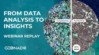
From data analysis to insights - Webinar replay
Просмотров 1512 месяца назад
Join Dr Karen Joyce on this webinar replay to learn how easy it is with GeoNadir to generate insights from your drone mapping data using a recent coral bleaching and mortality case study. This webinar will unpack how to: - Initiate meaningful collaborations and cut costs in data acquisition through our FAIR global map. - Use projects to compare datasets over different time periods. - Use simple...

Getting started with GeoNadir
Просмотров 1372 месяца назад
Welcome in to GeoNadir! You can view our ultimate guide to getting started here - help.geonadir.com/en/articles/9550458-the-ultimate-guide-to-getting-started If you would like an onboarding call with our team, please click here - fantastical.app/pchmead/15min-Paul-GeoNadir

Mapping mission planning with the DJI Mavic 3E
Просмотров 7084 месяца назад
Make sure that the controller is connected to wifi to view and cache the base maps before you start planning (swipe up on the screen to access settings). To work out your optimal flight altitude, see geonadir.com/optimal-drone-flying-height/ When you've completed your mapping mission, be sure to upload to www.geonadir.com for the best way to manage, process, and collaborate with your data.

Adding GCPs for drone mapping data processing
Просмотров 3575 месяцев назад
It's well established that incorporating ground control points (GCPs) into your data processing will give you greater positional accuracy and precision. Now it's super easy to do this as part of your GeoNadir workflow.

Filter drone mapping data by date captured
Просмотров 686 месяцев назад
When there's a whole lot of drone data over your area of interest, it's important to apply the appropriate filters to get exactly what you need. Here's how to reduce your options based on date captured.

GeoNadir Onboarding
Просмотров 6997 месяцев назад
Did you know you can analyse your drone data in a couple of quick clicks in GeoNadir? Sharing your insights and data with your team and stakeholders is simple. Let me show you how to get the most out of GeoNadir.

A quick tour of GeoNadir
Просмотров 4258 месяцев назад
Are you a keen drone mapper, or someone who appreciates spectacular imagery of the earth? Jump right in to #GeoNadir, the best place to manage, process, analyse, and collaborate with your drone mapping data.
Drone mapping to assess change
Просмотров 3368 месяцев назад
Summary This is a webinar hosted by Dr Karen Joyce from GeoNadir on using drone imagery to assess environmental changes from Tropical Cyclone Jasper. It covers accessing free high-resolution aerial maps, detecting changes in beach geomorphology, vegetation, infrastructure pre- and post-cyclone, collaborating via interactive map comments, capturing optimal data sets, and prioritizing areas to su...
Drone Mapping For Disaster Readiness
Просмотров 2969 месяцев назад
DRONE MAPPING FOR DISASTER READINESS Join Dr Karen Joyce, on Tuesday and learn how to be better prepared to assist before and after a disaster with your drone. This webinar replay covers the following topics: - Identify sites of interest as part of the disaster management cycle - Make mission plans - Prepare your data before the disaster hits
Do more with your DEMs from drone data
Просмотров 44710 месяцев назад
Do more with your DEMs from drone data In this webinar and learn how to: - Use DSMs and DTMs from GeoNadir in a GIS. - Create contour maps. - Generate a hillshade visualisation. - Extract feature heights. Presented by Dr Karen Joyce. A sample dataset to use in your GIS - drive.google.com/drive/folders/1OQxKn7chWyrLxI-OttqTC7UHNzNDwGP4?usp=share_link Sample Tile Mapping Service Link - api.geonad...
Mastering the New Workflow: Uploading Drone Mapping Data to GeoNadir
Просмотров 58310 месяцев назад
We are excited to announce significant updates to our workflow for uploading drone mapping data to GeoNadir, designed to enhance your experience and streamline the process of leveraging our platform for drone mapping. During this session, we'll walk you through the enhanced features, share best practices, and provide live demonstrations to ensure you make the most of the updated capabilities. H...
How to create a free user account on GeoNadir
Просмотров 127Год назад
Create your free #GeoNadir user account to store, share, and orthomosaic your #dronemapping data for free, as well as access #drone data from around the world
How to view 3d drone models in GeoNadir
Просмотров 316Год назад
How to view 3d drone models in GeoNadir
How to drone map - from capture to processing in GeoNadir
Просмотров 461Год назад
How to drone map - from capture to processing in GeoNadir
How to digitise drone mapping data on GeoNadir
Просмотров 600Год назад
How to digitise drone mapping data on GeoNadir
How to stream GeoNadir orthomosaics into ArcGIS Online
Просмотров 255Год назад
How to stream GeoNadir orthomosaics into ArcGIS Online
How to stream GeoNadir orthomosaics into QGIS
Просмотров 282Год назад
How to stream GeoNadir orthomosaics into QGIS
How to stream GeoNadir orthomosaics into ArcGIS Pro
Просмотров 178Год назад
How to stream GeoNadir orthomosaics into ArcGIS Pro
How to upload drone mapping data to GeoNadir
Просмотров 598Год назад
How to upload drone mapping data to GeoNadir
The Earth from above - A short film by GeoNadir
Просмотров 362Год назад
The Earth from above - A short film by GeoNadir
How to create a free user account on GeoNadir OLD
Просмотров 55Год назад
How to create a free user account on GeoNadir OLD
How to use DroneLink for a drone mapping mission
Просмотров 12 тыс.2 года назад
How to use DroneLink for a drone mapping mission
A Future From Above - GeoNadir - Short30
Просмотров 5052 года назад
A Future From Above - GeoNadir - Short30
How to use the Autel Explorer App for drone mapping mission planning
Просмотров 3,8 тыс.2 года назад
How to use the Autel Explorer App for drone mapping mission planning
How to use Litchi for Drone Mission Planning
Просмотров 5 тыс.2 года назад
How to use Litchi for Drone Mission Planning
How to use Agisoft Metashape to create underwater photomosaics
Просмотров 3,6 тыс.2 года назад
How to use Agisoft Metashape to create underwater photomosaics
Great tutorial. Going by the pointer, it seems like you are doing this on a PC. How are you doing this?
Hi, this was just done with a screen share of the iPad to my computer.
❤❤❤
Cool to see my orthomosaics of kamerunga bridge area being used in your presentation
hi, how can we make sure that the final image we achieving is of 2:3 ratio. Do we have to map it lil bit outside the area coverage so that we can mark it up on the image. Just trying to see any final images if you have to share, thanks
Can you program missions to video record the flight? I don’t need any photos, just video.
So helpful, thank you :)
Just signed up an account and looking forward to giving it a go, thanks Paul.
Would using this app to plan missions conflict with the crash avoidence of the Mavic 3. Newbie here. Be gerntle :)
Hi, welcome into the world of drones! Which version of the Mavic 3 have you got? The Mavic 3 Pro isn't compatible with this app. The Mavic 3 Enterprise has its own mapping app native to the controller. Hope that helps!
@@GeoNadir Have the Mavic 3 Pro. :( Found Waypointmaps, but have had difficulty getting planned missions to the controller/drone. Thank you for the response. For now I'll be doing it manually.
Thank you for the method, very intelligent process! If you only have one camera and scan the area in a zigzag pattern, is it necessary to separate the photographs into groups for each line covered, as if there were multiple cameras? Are the photos wide or linear angle?
Great tutorial!
Hi, by any chance do you have a video / tutorial on how you took the photos underwater?
Hi, great question. I don't actually, but it is pretty simple setup: 1 length of PVC pipe, 3 GoPros attached which are facing down. They are then set to take 1 photo per second. I also have a swim buoy with a GPS inside it trailing behind me. You can see the set up in the photo of my LinkedIn profile here - www.linkedin.com/in/drkjoyce/ There is also a GoPro facing forward in this photo, but that wasn't used for generating these 3D models.
This is excellent.. thank you for this video.. Good work
HIi, is this app still available as i cant find it on the App store?
Great
How is your GoPro camera array made? I really like the design
It is just PVC pipe stuck together with a joiner in the middle to make it easier to take apart and transport. Some pool noodles to get the floatation just right, and then GoPro clamps around the PVC pipe. Very cheap but effective!
"Gimbal Pitch" under Margin isn't shown on my app for some reason, any one know what this means?
Hi - you said it works with Android - cool - trying to install the Android APK called Ctrl+DJI which is required for Pix4D Capture to run - but the Android App store says - this product Ctrl+DJI is not available in your region Australia?
@4:40 you say you takeoff manually? How? Do you use the dji app to take off - or can the Pix4D Capture app allow you to take off manually? I not sure how you jump between manual and auto waypoint modes? Does the Pix4DCapture app land in the same spot it captured prior to take off? thanks ....
1. What happens if the mission is longer than your battery time. Does it return home manually? Can you pause the drone bring it home swap in another and return it back automatically where it left off? 2. If collision avoidance is on will it work using this app. It's an Mavic Air 2S
You can pause the mission and then fly back to change over the battery, it doesn't do this automatically. Once you have changed the battery, you will then take off and restart the mission and the drone should go back to its last point. Collision avoidance - not too sure...
alut- Geonadir-outstanding editing!ciao. 💯
Is GeoNadir free if I just want to upload the photos and download a large jpeg of the flight mission?
Yes, there is a free option that allows you to store and process your data. If you want to download an orthomosaic then you will need to have a paid subscription. You can join up for a month and there is no ongoing commitment required. Here is the pricing page - geonadir.com/pricing/
Best tool
Thanks! We think so too ;-)
Your voice Volume is too low.
I don't know what I'm doing wrong. But I don't see the same options under workflow. I see the following: "Align Photos", "Build Mesh", "Build Texture", "Build Point Cloud", "Build Panorama". I am trying to export a photomosaic like you did. Is this the same as Build Panorama? If so, then I still need help because even after I've processed Build Mesh the option Build Panorama is Greyed out. This is on Metashape Standard v2.0.1 build 16069 on macOS High Sierra.
Buy?
Good video ! How can I perform vertical paths (North-South) instead of the parallels (East-West). When I select the "polygon" mode, it gives a East-West paths (as in your clip). Thx.
Hi David, go into the options where you change the altitude etc, scroll over until you find 'course angle'. You can change this to whatever you like (90deg for North/South).
@@GeoNadir Thank you very much
Can I fly with DJI Mavic Mini also?
There is a list of compatible drones here - flylitchi.com/help
Hello, how are these individual image collections saved and transferred from the app to, say, and SD drive then to the PC? thank you
Hi! The images are saved on the SD card inside the drone as it is flying. Once the drone lands you can just take the SD card out of the drone, put it into a SD card reader and transfer these photos onto your computer, or upload them straight onto GeoNadir. GeoNadir will then stitch all of these individual images into one big picture called an orthomosaic.
Great video. Is the actual end result video butter pro smooth?
What do you mean?
Is Mini3pro good?
No, DroneLink doesn't support the MiniPro 3 - support.dronelink.com/hc/en-us/articles/360025829933-What-are-the-system-requirements-Supported-drones-and-devices-
it does now
Hi there, after that setting, the drone will take a photo every ....?? how that work?? cheers!!
The app calculates the time required to achieve the %overlap you set based on the camera field of view (i.e. the angle that it views at), the size of the camera frame, and the altitude you fly. So I can't say exactly the distance or time interval that it will acquire at. But it does it automatically so you don't have to worry about it :) Give it a try!
@@DrKJoyce thanks for the info !!
Hi! Is there a way to see the picture foot prints and the amount of picture that will be taken?
No, sorry, not in that app
@@GeoNadir Thanks!
One more question if I may... Do you have the steps to download a KML to Pixd Capture, or setting the location without being there?
Thank you!
Tgl dimana gan blh minta contak WA
Hi, I have a question... Am I able to enter an address or coordinates to plan a flight from home?
I also want to know, can we use this app for autel evo lite +?
Autel only allows the drone mapping mission to be done on the Evo models, not the Nano or Lite models, unfortunately.
I want to know how to get the data of mission planning from Autel Explorer App
Hello there. Do we need to set a few more of steps for parrot disco? ...since it cant not land vertically?
Excellent overview! Thanks.
Do you using this Android Tab or IOs Tab......
What is the pix4d + Ctrl parrot app for?
drone link is a one pay done deal? or its monthly?
You can do mapping with our one time payment Premium and Elite Hobbyist plans. But we also have have subscription plans for business users depending on the features and drones you require. Learn more here: app.dronelink.com/pricing
@@Dronelink hi i all ready buy the elite version, and have a issue at the time of inporting a kmz whit 1000hectareas, the web crashes. how can i fix it, or how can i import that kind of area?
I have drone link and as of right now, it is a one pay deal. What you pay depends on the type of drone that you have. Dronelink's system is mostly used with DJI drones and works best with them.
Like it!that's amazing -catch yo later-
Amazing resource. Thanks a lot for making this available!
How can I make a mission, by putting in an address I’d like to make the mission ?
do you take a video and extract the frames? or how you are capturing multiple pictures? cause to process these images in agisoft it needs geotags
We usually set the camera on 1sec capture interval. And Agisoft doesn't need geotags, which is really handy. We often tow a GPS and then tie the location to the photos based on time stamp, but we don't have to do that for Agisoft to work which is why we use it for this. Pix4D can also cope without geotags as well.
Thanks for the quick rundown. So just getting this straight. The app helps you capture the images to your drone automatically, but doesn't process them into a 3d model etc? Cheers Jake
Great product! How do you correct for refraction from lens to water?
Actually we don't - that would be nice though!